This is a continuation of the article.
Viewpoints
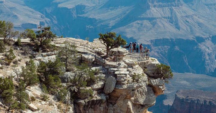
The main thing for which all tourists rush to the Grand Canyon is endless panoramic views that radiate tranquility and grandeur. Well, there are plenty of them in the park. Even within one southern part, you can create a whole collection of photographs. It doesn’t matter that no one except you can tell most of them apart, you will know that each point has its own name and its own face.
How did this canyon come about? Thanks to the restless Colorado River, which tirelessly made its way through easily susceptible rocks - limestone, sandstone, and shale. The decisive role was played by the movement of the earth's crust, as a result of which the flow of the river accelerated and became even more crushing. Add in soil erosion and voila, the canyon is complete. It only took a few million years.
Today we can admire the labyrinths of the canyon, filled with remains of the most bizarre shapes. Erosion also did its best, creating the extraordinary pattern of the Grand Canyon. The color scheme is also striking - the result of the accumulation of a variety of rocks: red, orange, yellow, brown layers make the gorge look like a large multi-colored pie.
Scattered viewpoints can be found along Hermite Road and Desert View Road.
Hermit Road
Hermit Road is a seven mile or eleven kilometer scenic drive that runs west of Grand Canyon Village. Along it you will find nine marked view points and many more unmarked ones)) You can walk these kilometers (as I wrote above, Hermit Road is a continuation of the Rim Trail), ride a bicycle, a free shuttle bus that stops at all observation platforms, or buy a bus tour. This road is only open to cars during the winter months.
To travel along Hermit Road on the free bus, you need to change to the Red Route at VillageRouteTransfer.
Viewpoints located along Hermit Road and the distance between them (in miles):
I suggest you take a closer look at view points. Andryusiks and I honestly watched all nine, although by the end we had completely stopped distinguishing one from the other. However, later, looking at the photos, we came to the conclusion that there was still a difference. Although this may be more a result of the changing lighting than the variety of landscapes.
Trailview Overlook
This vantage point offers excellent views of the serpentine Bright Angel Path and the village.


Maricopa Point
From Maricopa Point you can observe the canyon in its entirety and look for curious shapes created by the forces of nature.


Powell Point
Somewhere here is a memorial in honor of Powell and his expeditions to the Colorado River Valley, which took place back in the nineteenth century. We somehow got past it unnoticed, but I don’t think we lost much. In addition, the observation deck offers the same endless panoramas of the mottled labyrinths of the Grand Canyon.


Hopi Point
Hopi Point is popular at sunrise and sunset (along with Mother Point). In addition, from this point in a western direction you can see a piece of the Colorado River, which, I am sure, every tourist looks for, but it is very carefully hidden in the depths of the canyon.

Mohave Point
Mojave Point also makes a great vantage point for solar displays. Attentive tourists will see a brilliant thread of the river here too.


The Abyss
From here you can observe the canyon in a vertical section from the top to the lowest point. Now the Colorado River has cut through the rocks to granite, which is less susceptible to erosion than brittle sandstones and limestone, so further transformation is likely to occur at a slower pace.

Monument Creek Vista
Another observation deck that makes you want to jump out of the shuttle bus and stretch your legs. Buses run at intervals of about fifteen minutes, which is just enough time to look around and take a few shots.

Pima Point
From Pima Point you can clearly see the Colorado River. On calm days you can even hear it!


Hermits Rest
Hermits Rest is the end point on the red route. Here you can take a break, buy something to eat or drink coffee, look into the souvenir shop and replenish your supply of drinking water.
Grade: 8 out of 10.
Hermit Road on the map (red line)

Important! When using the shuttle bus, pay attention to the inscriptions: westbound are buses that go to the west, that is, “there,” and eastbound are buses that go to the east, that is, “from there.” Why is this important? Because in some places their movements coincide, but returning buses do not stop at all stops. You risk missing something.
Desert View Drive
Desert View Drive is a scenic drive east of Grand Canyon Village. Its length is about twenty-five miles or forty kilometers, along which tourists will find six designated view points. Some of them can be reached by shuttle bus (orange route), while others can only be reached by car.
I will be happy to show you the observation decks. We will move from west to east, towards the exit of the park.
Yaki Point
Andryusiks and I got here on an “orange” shuttle bus after we had dealt with the described Hermit Road. By the time we arrived, the weather had deteriorated noticeably, and the Grand Canyon became unsightly. Everything merged into one continuous blue veil. We did not wait for weather by the sea and postponed the remaining points until the next day.


Moran Point
I read that it is from this point that the layers of the Grand Canyon are clearly visible and you can easily study its geology. I don’t know, we didn’t pay attention to it early in the morning)) It’s just cute, what kind of layers are there))


Lipan Point
Lipan Point offers a glimpse of the picturesque bend of the Colorado River, whose red-brown waters are in constant movement, carrying sand, pebbles and washing away rocks.

Navajo Point - We deliberately missed this view point.
Desert View
Desert View is another "residential" part of the park's southern edge. There is a visitor center, camping, shops, in general, you can live here.
Tourists mainly drop by here to admire the same Colorado and climb the watchtower in order to have a view of three hundred and sixty degrees.


Grade: 7 out of 10.
Desert View Drive on the map

Grand Canyon Village
The village is the epicenter of life in the southern part of the park, linking Hermite Road and Desert View Road. There are hotels, the most popular campsite, shops, restaurants and cafes, museums, visitor centers, travel agencies and rental offices.
Parking lots in the south of the park
Having arrived in the southern part of the park, it is recommended to leave the car in one of the parking lots and then travel on foot or by free buses. You won’t get far anyway, since, for example, Hermit Road is closed to private vehicles from March 1 to November 30.
The largest and most convenient parking lot is located next to the Grand Canyon Visitor Center, in the Mother Point area. So come here to watch the sunrise, leave the car before all the seats are occupied and go explore the park, forgetting about the steering wheel.


North Rim of the Grand Canyon
In addition to the southern part (South Rim), the northern part of the park is also open to the public. It is much less popular among tourists, but, judging by the reviews, no less, if not more, interesting and picturesque. I have nothing to tell about North Rim, since Andryusiks and I were not there.
Apparently, there are places to walk and ride there.

Thank you for the useful information
Was the article useful? Say thank you
No description can truly prepare a person for the scale and grandeur of this enormous gorge, stretching into the distance as far as the eye can see, a grandiose complex of canyons, waterfalls, caves, towers, ledges and ravines. The Grand Canyon always seems to look new, and the sun's rays and shadows from passing clouds cause the rocks to constantly change shades of color in an exquisite range from black and purple-brown to pale pink and bluish-gray. Finds in the caves indicate that the first inhabitants appeared in the Grand Canyon around 2000 BC. Less than 10 million years ago, the Colorado River meandered across a vast plain. Then movements of the earth's crust forced this area to rise, and the river began to cut into the rock. Soft limestones, whose age was estimated at 2 million years, were the first to be eroded, and then came the turn of older shales and sandstones located in deep layers. The oldest layer was formed by the 2 billion-year-old granites and crystalline schists that form the bottom of the canyon. The main canyon stretches 365 km in length and reaches approximately 29 km at its widest part. Its depth in some places reaches 1.6 km. There is no bridge across the gorge, and anyone wishing to cross from North Rim Headwaters (North Rome Headvoters) to the Grand Canyon village located on the southern shore, and the distance between them in a straight line, through the canyon, does not exceed 19 km, will be forced to overcome more than 322 km.

 A riot of colors

Here you can enjoy an incredible palette of colors, looking at the scarlet, golden and orange cliffs, purple abysses, crystal clear waters, thanks to which these places are considered one of the most beautiful corners of the Earth. After seeing the sun set at the Grand Canyon, the poet Carl Sandburg exclaimed: “Here comes the Lord with an army of standard-bearers!”
The South Rim of the Grand Canyon is the most popular location because it is easily accessible from the highway that runs parallel to the canyon rim. There are several observation platforms and hiking trails here.
The northern edge, where the height of the canyon walls becomes much more noticeable, is visited by tourists much less often, because getting here is not so easy. The Tuwip area is still accessible via a few dirt roads and offers stunning views, but the area is generally inaccessible to cars.
In addition to the Grand Canyon, there are many side canyons and gorges, but most of them require time or difficult rafting on the Colorado River to explore.
After just one trip here, you begin to understand why this place is so popular and why it is considered a unique natural wonder.
Ancient Navajo legends tell of a brave hero named Packit-haawi. He put an end to the Great Flood by taking a heavy club and splitting the solid earth so that all the water could escape into the resulting crack. Geologists say that the gorge was formed over 40-50 million years, while the waters of the Colorado River persistently deepened their bed.
For tourists

On March 20, 2007, the opening of a unique structure took place - the Sky Bridge (Grand Canyon SkyWalk), the world's first glass bridge, soaring over the beauty of the Grand Canyon at an altitude of 1200 meters!!! A bridge in the shape of a horseshoe, the extreme point of which is located 20 meters from the edge of the abyss! No cables or brackets restrict all-round visibility. The transparent floor of the bridge allows you to feel like an eagle soaring over the scorching expanses of the prairie. This observation deck is 2 times higher than the Ostankino Tower, the Taipei 101 Tower in Taiwan is 2.5 times higher, and the Empire State Building in New York is more than 3 times higher! Admission fee is $25 in addition to the cost of entry to the West Rim of the Grand Canyon.

The park itself is very simple (American style convenient and comfortable). There is a road along the edge of the canyon. Periodically (every 4-10 miles) There are well-equipped viewing areas, observation decks, marked parking near each and permanent parking spaces for the disabled. At these sites, as a rule, a fence is installed so that someone does not fall and file a lawsuit that will ruin the entire US national park system. Some sites are located on rocks that protrude somewhat into the canyon, allowing you to enjoy a 270-degree view. At select Desert Overlook and Canyon Village viewpoints (Desert View, Canyon Village) there are souvenir shops where you can buy real and high-quality (usually in China) calendars, DVDs, maps and other souvenir trinkets. The staff is friendly and will definitely suggest a place for the best sunset photography.
If possible, it is best to avoid visiting the Grand Canyon during the influx of visitors between May and September. There are campsites and hotels near the Northern Rim, but this is a place for local regulars. Beginners should stay at the South Rim.
When planning to stay at a campsite, reserve a spot in advance; You can also rent accommodation in Grand Canyon Village. In the local kiosks you can get information about routes, both on foot and on mule, down the canyon; or about rafting on the Colorado River. Hiking or riding a mule requires courage. River rafting gives you the opportunity to see the canyon under the supervision of experienced guides.


The Grand Canyon Village Visitor Center will help you get started. Along Rim Drive, small information kiosks provide tourists traveling by bus or bicycle with interesting information about the local geology, vegetation, animals and people who lived in the area. Particularly attractive is the information about the Indians, whose dwellings in the rocks of the canyon are still visible from the Northern Rim.
There are wonderful hiking trails up along the edge of the canyon through thickets of juniper and edible pine. Every now and then you find yourself in a clearing at the edge of the canyon, where you can see huge mounds or hills, rising like Egyptian pyramids or Aztec temples and bearing names such as the Zoroastrian Temple or the Pyramid of Cheops. There are also rock formations with sonorous names: Skeleton Cape and Ghost Manor.
Shuttle buses travel along the 13-mile West Rim, which is closed to private traffic from May to September, stopping at spots with stunning views of the canyon: Hopi Point, Mohave Point and Pima Point. There are other buses passing frequently that can take travelers.

Walking should be undertaken by a physically well-trained person; Despite the short distances, the terrain here is rugged and the heat is intense. Wear hiking boots, protective clothing, a wide-brimmed sunhat, apply sunscreen, and bring drinking water.
The easiest route is the Bright Angel Trail (Bright Angel Trail), starting from the Bright Angel Shelter (Bright Angel Lodge). Set out at dawn with the expectation that the descent will take three hours and the ascent will take six to seven hours. The path, winding, after 2.5 km leads to the first resting place, where an emergency telephone is installed, and after another 2.5 km - to the second resting place - the so-called biblical Jacob's Ladder (Jacobs Ladder), and, already walking almost straight, reaches the wonderful Indian garden (Indian Garden) at the Garden Stream. Here, in the tent camp near the ranger's lodge, you can spend the night, provided that you have reserved a place, which you need to take care of at least six months before arriving here.

Hikers can continue their journey the next day along the Garden Stream, bypassing the Devil's Gimlet (Devil's Corkscrew) down Pipe Creek to the Rechnoe rest area next to the Colorado River. If booked in advance, travelers can stay in the barracks-type premises of the Phantom's estate. A more difficult route is along the steep Kaibab Trail (Kaiba Trail), coming from Yaki Point Road east of Grand Canyon Village.
Pedestrian trails allow you to get away from the crowds on the Rim Drive, although here you can always step a hundred meters to the side and enjoy the beauty of the natural wonder in silence.
Information
The most developed area in the park is Grand Canyon Village (Grand Canyon Village), which is 9.6 km north of the entrance to the South Rim (South Rim Entrance Station). The only entrance to the North Rim is located 48 km south of Jacob Lake (Jacob Lake) on the highway (highway) 67. The road from the North Rim to the South Rim will be 344 km if you drive a car, 33.6 km if you walk through the canyon, or 16 km for a flying condor.

Entrance ticket to the park (vehicles/cyclists and pedestrians $25/12) valid for seven days, it can be used on both sides.
Overnight hiking and camping in the park's backcountry areas require a permit. Remote Area Information Center (Backcountry Information Center; Tel: 928-638-7875; Fax 928-638-7875; www.nps.gov/grca; Grand Canyon Village (Grand Canyon Village); 08.00-12.00 and 13.00-17.00, telephone service 13.00-17.00 Mon-Fri) accepts applications for backpacker permits ($10, plus $5 per person per night) only for the current month and the next four. You have a decent chance if you apply early. (for four months, spring and autumn) and offer alternative walking routes. The application is accepted in person, by email or fax. For more information, visit www.nps.gov/grca/planyourvisit/backcountry.htm. If you arrive without permission, go to the office near Maswik Lodge and sign your name on the waiting list.
Southern region

You can get information not only from the visitor centers listed below, but also from the park itself at the Yavapai Observation Station (Yavapai Observation Station), in the Vercamps tourist center (Verkamp's Visitor Center), Hotel El Tovar. Tusayan Museum (Tusayan Ruins & Museum) and Desert View Visitor Center (Desert View Information Center). Grand Canyon Visitor Center (Grand Canyon Visitor Center; Tel: 928-638-7644; 8:00 a.m. - 5:00 p.m.) The Grand Canyon Visitor Center and Books & More are located in the plaza three hundred yards behind Mather Point. An information board in the plaza displays messages about ranger programs, weather, tours and walking tours. The interior of the center is light and spacious, with staff from the forestry department on duty at the information stand; In the lecture hall ministers give lectures daily.
Tusayan

National Geographic Tourism Center (National Geographic Visitor Center; Tel: 928-638-2468; www.explorethecanyon.com; Hwy. (highway) 64, Tusayan (Tusayan); adult/child $13/10; 8.00-22.00) located in Tusayan, 11.2 km south of Grand Canyon Village; pay $25 to enter a vehicle and save time on a potentially long wait at the park gate, especially in the summer. The IMAX theater is showing the stunning 34-minute film "Grand Canyon - Hidden Secrets" (Grand Canyon - The Hidden Secrets).
Northern region
Northern Territory Tourist Center (North Rim Visitor Center; Tel: 928-638-7864; www.nps.gov/grca; 8:00 a.m. - 6:00 p.m., closed mid-October to mid-May) Located next to the Grand Canyon Lodge; maps, books, road routes and weather information.
How to get there and get around

Most tourists come to the canyon by private car or on a guided tour. Finding a parking space in Grand Canyon Village can be difficult. Under the new "Park and Ride" program (Park-n-Ride) in the summer, visitors can purchase a park ticket at the National Geographic Visitor Center (National Geographic Visitor Center), park your car in a designated place and take a free bus that goes through the park along the Tusayan Route road (Tusayan Route; 8.00-21.30 mid-May-early September) to the Grand Canyon Visitor Center . A park pass also works for this option. The trip takes 20 minutes, the first bus leaves for Tusayan at 8.00 am. The last bus from the park leaves at 21.30.
Free buses run through the park on three routes: around Grand Canyon Village, west along Hermit's Rest (Hermits Rest Route) and east along the Kaibab Trail (Kaibab Trail Route). Buses usually run at least twice an hour, starting an hour before sunset and ending an hour after it.
During the summer months there is a free Hiker's Express bus service. (at 4.00, 5.00, 6.00 June-August, 5.00, 6.00, 7.00 May and September). It departs from the Bright Angel Lodge and picks up tourists at the Backcountry Information Center (Backcountry Information Center) and Grand Canyon Visitor Center (Grand Canyon Visitor Center) and then goes to the South Kaibab trailhead (South Kaibab).
Transcanyon Shuttle Bus (Tel: 928-638-2820; www.trans-canyonshuttle.com; one-way/roundtrip $80/$150; 7 a.m. mid-May to mid-October) departs daily from Grand Canyon Lodge to South Rim (5 hours), which is suitable for tourists traveling from one edge of the canyon to the other. Reserve your spot at least one or two weeks in advance. Free tour bus to North Kaibab Trailhead (North Kaibab Trail) departs at 5:45 and 7:10 am from the Grand Canyon Lodge. You need to make an appointment at the reception department; If no one checks in the night before departure, the bus will not depart.
Bicycle rental

Bright Angel Bicycles bike rental (Tel: 928-814-8704; www.bikegrandcanyon.com; full day adult/child $35/25; 8am-6pm May-September, 10am-4:30pm March-April and October-November, weather permitting) Comfort cruiser bike rental: friendly staff will help you find any bike to order. The price also includes helmet and bike lock rental.
Geology
Here you can find traces of four geological eras of the Earth, a variety of rocks and caves containing rich geological, biological and archaeological material. The Grand Canyon is considered one of the best examples of soil erosion. The Colorado River originally flowed across a plain, but crustal movement uplifted the Colorado Plateau about 65 million years ago. As a result, the angle of inclination of the river flow and, as a result, the flow speed and the ability to destroy rock lying in its path increased. First, the river eroded the upper limestones, and then began to take over the deeper and more ancient sandstones and shales. This is how the Grand Canyon was formed. This happened about 5-6 million years ago. The canyon is still growing due to ongoing erosion.
Along the Grand Canyon by bike
In our time, the most ancient rocks have already appeared at the bottom of the gorge - granites, the destruction of which occurs much more slowly. The waters of the Colorado rush through the gorge at a speed of 20 km per hour, rolling huge boulders and pebbles along the bottom and carrying with them so much sand and clay that the river becomes completely opaque and acquires a red-brown tint. Colorado carries about half a million tons of rock into the sea every day. The rocks and sand carried away by the river increase the destructive effect produced by the Colorado, and even the hardest granites of the canyon bed are worn down by this “sandpaper” a quarter of a millimeter annually.
The huge expanse of the gorge does not look like just a long narrow hole in the ground. It is filled with chaotic clusters of rock outcrops that have the most bizarre shapes. Landslides, water and wind erosion created the outlines of giant pagodas, pyramids, towers, and fortress walls in the walls of the canyon, representing a spectacle of unique beauty and grandeur. Many of them have their own names: Temple of Vishnu, Temple of Shiva, Throne of Wotan, etc. The entire varied stone labyrinth, like the gigantic walls of the canyon, is lined with alternating yellow, pink, red, brown and brown layers of sedimentary rocks that make up the plateau. These are perhaps the most complete geological outcrops in the world, representing the history of the Earth over 1.5 billion years.
Now the floor of the Grand Canyon has dropped at least 1000 m in depth from the level to which it was once raised by tectonic activity. The erosion process continues. Someday, in the very distant future, the Grand Canyon will cease to exist altogether.
Climate and nature
The climate on the plateau and at the bottom of the canyon differs sharply - when it is about 15 °C at the top, at the bottom of the gorge, among the hot stones, the temperature can rise to +40 °C.

The wildlife of the canyon is interesting. At the bottom of the gorge is a typical desert landscape of the Southwestern United States with a variety of cacti, agaves, and yuccas. As you rise, you begin to encounter thujas, oaks, aspens, and willows; the zone of pines and junipers extends even higher. The rich fauna includes about 100 species of birds and 60 species of mammals, including several extremely rare species.
June is the driest month of the year, July and August are the wettest. In January, the average night temperature drops to -11°C -7°C, and daytime temperatures reach approximately 4°C. In summer, the air temperature in the canyon regularly rises above 38°C. The South Rim of the Grand Canyon is accessible to tourists all year round. Most visitors arrive between late May and early September. The North Rim is open from mid-May to mid-October.

History of research
In 1540, a detachment of Spanish soldiers, searching for the legendary Seven Cities of Gold of Quibola, came to the edge of the gorge. Stunned by the sight before them, the Spaniards fell to their knees and began to pray. For three days they looked for a path to go down into the gorge, but they never found it. Their water and food supplies ran out and they returned to Mexico empty-handed.
In 1858, Joseph Eaves sailed from the Gulf of California up the Colorado River on the ship Explorer. He wanted to determine the length of the navigable part of the river, but soon ran aground. At this point, Eaves had to end the expedition and return to where he reached the Grand Canyon. It was only in 1869 that Major John Wesley Powell became the first explorer to navigate the entire course of the Colorado River. His expedition marked the beginning of scientific study of the Grand Canyon.
Following Powell, many scientists visited here. The Grand Canyon has become a real treasure for geologists, because the layers of ancient sediments exposed by the river can be considered the library where information about the history of the Earth is stored. The oldest formations discovered on these slopes are 1.7 billion years old - there are no more ancient rocks anywhere in the world! And the Colorado River continues its painstaking work for the glory of archaeology, exposing more and more layers of rocks to science every year.
Grand Canyon SkywalkFacts
- Title: Grand Canyon.
- Location: USA. Arizona State.
- Dimensions: The Grand Canyon is approximately 450 km long, 30 km wide at its widest points and 1.8 km deep in some places.
- National Park and UNESCO World Heritage Site: Grand Canyon National Park was one of the first in the United States to be established in 1919, and was added to the UNESCO World Heritage List in 1979.
The Grand Canyon Historic Village has been lived in since the late 1800’s. These are some of the can’t miss sites that you should visit.
Grand Canyon Historic Village Sites:
- Hermit's Rest – Built in 1914 to look like an old miner’s cabin by the renowned Southwest architect Mary Jane Colter, Hermit’s Rest has a magnificent giant fireplace and front porch. Enjoy a cup of chocolate and shop for souvenirs at the lovely gift shop. Hermit’s Rest can only be visited by the Park Shuttle as the road is closed to private vehicles.
- El Tovar
– A famous landmark for the South Rim, the beautiful El Tovar hotel was built in 1905 and has housed great dignitaries such as Theodore Roosevelt, Albert Einstein, author Zane Gray, President Bill Clinton and Paul McCartney. The lodge offers accommodations, fine dining, gift shop and lounge. This is a must-see attraction of the South Rim!
www.grandcanyonlodges.com/lodging/el-tovar Phone: 888-297-2757 or 303-297-2757 - Bright Angel Lodge – This historic and rustic lodge is a registered National Historic Landmark, designed by Mary Jane Colter and built in 1935 to be a charming but more affordable alternative to the elegant El Tovar Lodge. The famous Fred Harvey Company operated the lodge with restaurants and accommodations, even including two historic cabins, Bucky O’Neill cabin and the Red Horse Cabin. Today, the lodge and cabins are still available to book and enjoy a unique part of the Grand Canyon history. Bright Angel also presents an exhibit on the history Fred Harvey.
- Kolb Studio – Ellsworth and Emery Kolb were important early photographers of the Grand Canyon and built a studio on the South Rim ledge in 1904. The studio has art exhibits, bookstore and auditorium for lectures.
- Desert View Watchtower – Built in 1932, the 70 ft. watchtower is the highest point on the South Rim and presents a 360-view of the South Rim. You can see views of the Painted Desert, San Francisco Peaks and Vermilion Cliffs. There are beautiful murals painted on the walls of the staircase by Hopi artist Frank Kabotie. A gift shop sells local Native American items such as jewelry and pottery.
- Hopi House – The Hopi House was designed in the adobe peuble style of the Hopi Indians and opened as a gift shop in 1905. The architect Mary Jane Colter wanted to honor and incorporate the beauty of Native American designs into the Grand Canyon experience. The gift shop is still sells authentic high quality Native American art and crafts.
- Lookout Studio – Hovering right on the edge of the rim, the Lookout Studio is exactly as it’s title suggests – a terrific look-out over the South Rim. Built in 1914 as an observation point and gift shop for Fred Harvey, the Lookout Studio now sells photography prints, rock specimens and books.
- The El Tovar Stables (1904) were built to house horses and mules used for transportation around the park in pre-automobile times, and continue to be used to house mules for trips to. Individually listed on the NRHP.
- Verkamp's Curio Store (1906), is now Verkamp's Visitor Center, and is operated by the Grand Canyon Conservancy for the National Park Service. Built by Ohioan John George Verkamp, who sold Native American crafts and souvenirs, the two-story shingled building has been described as “modified Mission” style, resembling an adobe building in form if not materials.
- The Grand Canyon Power House was built by the AT&SF to provide electricity to concessioner and park facilities. The Power House is notable for its application of rustic design principles to an industrial structure and for its creative use of scale. It is an individually listed National Historic Landmark.
- The Grand Canyon Depot (1910) and Grand Canyon Railway (1905) were built by the AT&SF. The depot, designed by Francis W. Wilson, is an individually listed National Historical Landmark, and the railway is on the National Register of Historic Places.
- The AT&SF Employee residences were built to house concessioner employees. Both the subdivision and the houses themselves are larger than the Park Service equivalent, with garages to the rear of the houses on alleys.
- Colter Hall, designed by Mary E.J. Colter and located behind El Tovar, was originally a dormitory for the Harvey Girls. It serves as employee housing today.
Grand Canyon National Park (USA) - exact location, interesting places, inhabitants, routes.
- Last minute tours all over the world
Previous photo Next photo


Grand Canyon National Park is one of the oldest national parks in the United States. The canyon is located in Arizona. Until the first Europeans arrived here in 1540, the Pueblo Indians lived in the canyon. They lived in caves that were dug right into the canyon. But one day the beauty of the landscapes of these places was appreciated by President Theodore Roosevelt, who loved to come here to hunt, and the Grand Canyon quickly became very popular.
The name of the canyon is not accidental: it is truly the largest canyon on the planet, its canyon length is almost 500 km, its width is 28 km, and its depth is 1.6 km. This canyon is not the deepest in the world, but it is obviously the most impressive in its landscape. The relief in the form in which we can observe it today began to form approximately 75 million years ago. Then the Colorado Plateau rose by about 3 km, a huge chasm formed, and 18 million years ago the waters of the surrounding rivers began to flow into it. Over time, the soft rocks were washed away, and today the canyon (especially its bottom) is a structure made of hard rocks; destruction occurs very slowly and will certainly continue for more than one million years.
Archaeologists still work in the canyon to this day and often find scientifically interesting fossils. As for living inhabitants, 355 species of birds, 89 mammals, 47 reptiles, 9 amphibians and 17 species of fish live here.
Grand Canyon Climate
The climate of the national park is complex and varied, as it consists of several ecosystems. The low end is similar to Arizona's desert climate with dry, hot summers. In the upper, wooded part of the canyon, snow falls in winter. The air temperature in summer reaches +37 °C, in winter -17 °C.
The southern part of the canyon is open all year round, 24 hours a day. Northern part - from May to October.
3 things to do in the Grand Canyon
- Capture with your camera the memorial sign, which is located on one of the paths leading to the observation deck and is decorated with the inscription: “The tribes that call the Grand Canyon home: Apache, Navajo, Zuni, etc.”
- Take advantage of a helicopter tour over the Canyon.
- Repeat the route of Powell's expedition, rafting along the fast waters of the Colorado River.
Canyon regions
The most popular region of the canyon is the South Rim. This is where all the observation platforms and other attractions are located. the most visited, there are also popular observation platforms here. In the southern part of the park, reservations of the Havasupai and Walapai tribes have been preserved. They are wary of strangers here, just as they were thousands of years ago, but today the locals already feel safe and ready for guests.
The northern region is less suitable for tourists. There are many hard-to-reach trails, and in winter this part of the park is completely closed to the public. However, those who are not lazy to get here are not disappointed: in the north of the canyon there is very interesting flora, fauna, landscape, and even a slightly different climate.
Attractions
Almost all the sights of the Grand Canyon have poetic names: Temple of Vishnu, Temple of Shiva, Throne of Wotan, etc. Above the river you can see Bucans Stone - a black ash cone, as well as the red sandstone terrace Esplanade, which is especially beautiful in the rays of the sun at sunset .
North Canyon Boche has very picturesque lakes at the base of centuries-old stone walls. And from one of the most beautiful dams - the Hoover Dam - an incredibly beautiful view of the largest man-made lake in the USA - Lake Mead - opens up. For the convenience of tourists, an observation deck has been specially built here.
Traveling through the canyon
There are several ways to travel through the canyon: on foot (there are many convenient walking trails in the park). The beauty of such a trip is that you can slowly enjoy the ever-changing landscapes. For example, the same place at dawn and in the evening after sunset can look completely different.
You can go rubber rafting on the Colorado River. Well, the most interesting and “cowboy” way is horseback riding or traveling on mules. The cost of this pleasure: from 45 USD per hour. There is also a train on which you can ride along the edge of the gorge, bicycle rental and car rental. For extreme sports enthusiasts, there is a small plane (a flight over the Grand Canyon will cost approximately 389 USD) and a hot air balloon. Prices on the page are as of September 2018.
Grand Canyon
Observation platforms
There are quite a few viewing platforms throughout the Grand Canyon in different parts of the park. The most expensive of them is Skywalk. This is a huge platform with a transparent bottom; it costs 83 USD to visit. Also popular among tourists is the Sky Path - a glass bridge in the shape of a horseshoe, which hangs in the air at an altitude of 1219 m.
Practical information
How to get there: by plane to Las Vegas, from there by train to Flagstaff (about 330 km), and from Flagstaff to the Grand Canyon (another 100 km) there are buses and shuttles; however, given the not always convenient public transport schedule, experienced travelers recommend renting a car.
Entrance: for pedestrians and cyclists - from 12 USD, for cars - 25 USD (for 7 days); visiting observation platforms is paid separately.