Description of the presentation by individual slides:
1 slide
Slide description:
2 slide
Slide description:
3 slide
Slide description:
Middle Ages On the territory of Primorye in the Middle Ages there were three empires, successively replacing each other: Bohai (698-926), Jin (1115-1234), Eastern Xia (1215-1233). This period in the history of the region is characterized by the emergence of inequality and classes, the formation of government bodies beyond the control of the people, which are based on legitimate violence. The economy is characterized by qualitative transformations of the economy (primarily its productive forms, such as agriculture), the development of crafts and trade. Economic development leads to the emergence of the first cities. In the field of culture, the polarization of ideology begins, the division of culture into elite and mass. From the beginning of the 8th century, the territory of the region was part of the state of Bohai (or Parkhe) and at that time was divided into at least two territorial and administrative units: the Shuaibin region, named after the Suifun River (now Razdolnaya), in the valley of which its center was located, and Yan District (Yanzhou), with the center located near the modern village of Kraskino in the Khasansky district. In 926, Bohai was destroyed under the onslaught of the Khitan, after which the unification of part of the Heishui Moeh (Jurchen) tribes began, which culminated in the creation of the state of Jin, which defeated the Khitan Liao Empire in 1125. Later, during the wars with the Chinese Empire, the Song Jin managed to capture all of Northern China and hold it for a century. At the beginning of the 13th century, the territory of East Asia was subjected to Mongol invasions. This led to the loss of the eastern territories of the Jin Empire, which became the independent state of Eastern Xia. At this time, Primorye, which was a distant outskirts, became one of the central regions of the new Jurchen state. However, in 1233, after passing through Goryeo, Mongol troops besieged the southern capital of Eastern Xia, and from that moment on, the state ceased its 19-year existence. The final result of the Mongol invasions was the destruction of ancient civilizations, devastation and devastation of Primorye. As one of the Chinese chroniclers wrote, “in the place where cities stood and bustling life was in full swing, desolation reigned and wild animals grazed.” From the perspective of official Russian historiography, until the advent of Russian pioneers, the region remained untouched and forgotten, which was partly facilitated by the policy of self-isolation carried out in China and Korea in the 17th-19th centuries. This, however, is not confirmed by the testimony of the Russian pioneers themselves, in particular, Erofey Khabarov, who in his “responses” reported to the leadership that “with those people, Dmitry Andreevich and Osip Stepanovich, it is not possible to take possession of that land, because that land is populous and a fiery battle"
4 slide
Slide description:
5 slide
Slide description:
6 slide
Slide description:
7 slide
Slide description:
XIX century - early XX century In the middle of the 19th century, Russia began to strengthen its position on the northwestern coast of the Pacific Ocean. In 1856, from the coastal parts of Eastern Siberia, together with Kamchatka, the Primorsky region was formed, from which the Amur region was separated in 1857. In 1858, the Primorsky region included all the space newly acquired under the Aigun Treaty, the space between the right bank of the Amur, the Ussuri River and the Sea of Japan, the city of Nikolaevsk was made the center of administration of the region, where the fleet was transferred from Petropavlovsk, however, this territory was declared at that time in joint economic management of Russia and China. In the same year the village of Khabarovka was founded, and in 1859 Sofiysk was founded. On June 20 (July 2, new style), 1860, Vladivostok was founded as a military post. On November 14 of the same year, the Beijing Treaty was signed, the result of which was the transfer of the southern lands of the Far East under the full jurisdiction of Russia, since then the southern part of Primorye has taken its current shape. At the same time, the resettlement movement began, which was carried out in two ways: forced and voluntary. In the first case, military commands were sent by order, Cossacks were sent by lot, peasants were sent as recruits, administrative installation of state peasants, exile of Cathars, etc. The voluntary method, in contrast to the forced one, was characterized by the free resettlement of those who wished to new lands.
8 slide
Slide description:
Revolution and Civil War Immediately after the October Revolution, during which the Bolsheviks came to power, the “Decree on Peace” was announced - Soviet Russia concluded a truce on December 2, 1917 and withdrew from the First World War. On March 15-16, 1918, a military conference of the Entente was held in London, at which the issue of starting an intervention was discussed. On August 1, 1918, British troops landed in Vladivostok. In the Far East, the interventionists held out until 1922. At this time, the border of Primorye was poorly guarded, which allowed thousands of Korean immigrants to cross into Russia, most of whom settled in the Vladivostok district, making up 90% of the population in the Posyet region. Chinese immigrants also crossed the border, who, unlike the Koreans, came to Primorye, as a rule, for seasonal work. On April 6, 1920, the Far Eastern Republic (FER) was proclaimed, which included, among other things, the Primorsky region. On November 22, 1920, the Amur region of the Far Eastern Republic was formed from the Iman, Sakhalin, Ud and Khabarovsk districts of the Primorsky region with its center in the city of Khabarovsk. On May 26, 1921, in the southern part of the Primorsky region, as a result of the overthrow of the Bolshevik government, an independent state entity was formed - the Amur Zemsky Territory. In November 1921, a campaign against Khabarovsk and Anuchino began from Vladivostok, which ended in failure.
Slide 9
Slide description:
10 slide
Slide description:
Soviet period In the 30s, accelerated industrialization and collectivization of agriculture began. This led to the migration of residents of the western and Siberian regions of the USSR to the Far East. Migration was both voluntary and forced (deportation of Gulag prisoners). At the same time, the Stalinist leadership pursued a policy of ethnic and socio-demographic cleansing, which resulted in the eviction of several tens of thousands of “unreliable” and “socially alien” persons. In 1937 - 1938, 200 thousand residents of Korean (to Kazakhstan and Central Asia) and Chinese (mainly to China) nationalities were forcibly deported. As a result of ethnic deportations, until the end of the 80s of the 20th century, the Chinese and Koreans disappeared from the national composition of the population of Primorye. In the summer of 1938, on the southernmost border of the Primorsky Territory, in the area of Lake Khasan, military clashes took place between Manchukuo (a puppet state controlled by Japan) and the Soviet Union, which went down in history as the Battles of Khasan. The cause of the conflict was Japan's claims to the territory Lake Khasan and the Tumannaya River, as a result of two-week clashes, the USSR won. The losses of the USSR amounted to 960 dead, 2,752 wounded, the losses of the Japanese side were 650 killed, 2,500 wounded. In the same year, on October 20, by decree of the Presidium of the Supreme Soviet of the USSR, the Primorsky Territory was formed as part of the RSFSR with its center in Vladivostok, which included the Primorsky and Ussuriysk regions of the Far Eastern Territory. On September 18, 1943, the Ussuri region, previously part of the Primorsky Territory, was liquidated. After the end of the Second World War, the Primorsky Territory continued to develop as a large industrial and agricultural region of the Far East, but at the same time retained its specialization in raw materials. Rail and sea transport played a significant role in the economy of the region. On September 15, 1948, the Presidium of the Supreme Council of the RSFSR decided to “Transfer the city of Sovetskaya Gavan along with the suburban area from the Primorsky Territory to the Khabarovsk Territory.” In the mid-60s. In the 20th century, industries that were not previously available in the region were created: chemical, electrical, instrument-making, tools, porcelain, furniture, etc. At the same time, the migration of residents of the European part of Russia and Siberia continued, which led to an increase in the population of the region, with 1381 thousand people in 1959 to 1978 thousand in 1979, while the urban population predominated in the socio-demographic structure of the region.
Filatkina Irina, Filatkina Marina
In this presentation you can find a lot of beautiful and interesting material about the Primorsky Territory (Sikhote-Alin mountains, lotuses, Ussuri tiger, Far Eastern leopard, Ussuri taiga, endemics of Primorye, Khanka Island, Ussuri River). The material can be used both in lessons when studying Primorye, and as a separate project for a class hour as part of the days of Primorye in Russia.
Download:
Preview:
To use presentation previews, create a Google account and log in to it: https://accounts.google.com
Slide captions:
Primorsky Krai is located in the very south of the Russian Far East, stretching from north to south along the shores of the Sea of Japan. In the west it borders with China, in the very south with Korea, in the north with the Khabarovsk Territory. Its area is 165 thousand square kilometers, which approximately corresponds to the size of the average region of Russia. However, by European standards, the region is huge; countries such as Belgium, Holland, Denmark and Switzerland combined could fit on its territory. The southeastern part of the region is washed by the waters of Peter the Great Bay, dissected off the coast by many bays and bays. Briefly about the region as a whole, we can say that it is a large industrial region of the Far East, the economy of which specializes in the fishing industry, mining and beneficiation of non-ferrous metal ores, forestry and woodworking industries. Agriculturally, it is known as a producer of soybeans, rice, wheat, oats, as well as orchards and vineyards.
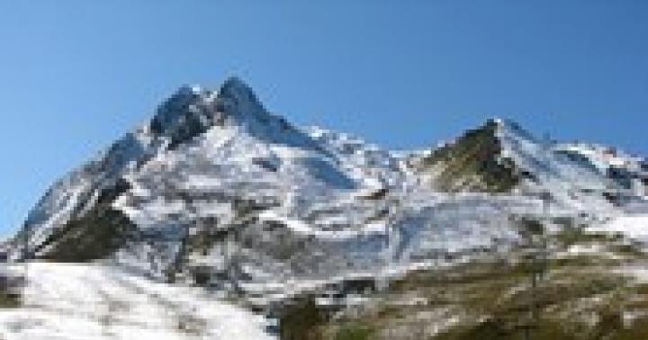
Travelers are attracted by the unique nature of the region. Most of its territory is occupied by the Sikhote-Alin mountains. These are mainly ridges with rounded dome-shaped peaks and gentle slopes, the average height of which is 600-700 meters. However, there are also real mountains. The highest mountain here is Oblachnaya – 1855 meters. Mountain ranges stretch parallel to each other, and there are very few lowlands, they exist only along river valleys, near Lake Khanka and along the sea. 80% of the entire territory is hills. The mountainous country of Sikhote-Alin stretches for 1000 kilometers and is 250 kilometers wide. In the south, chains of mountains run parallel to Peter the Great Bay, breaking up into numerous spurs, one of which forms the Muravyov-Amursky Peninsula. The shores of the peninsula are indented by numerous bays and are washed from the west by the waters of the Amur Bay, and from the east by the Ussuri Bay. Here, on the Muravyov-Amursky Peninsula in its southernmost part, the city of Vladivostok is located - the capital of the Primorsky Territory.
Komarov's Lotus is a very beautiful elusive pearl of the Far East, listed in the Red Book. Lotus is a tropical East Asian plant that grows only in the Far East, a representative of the most ancient flowering plants, and has scientific value as a relict of the Gondwanan (first continent) flora that existed more than a hundred million years ago in the Mesozoic era. Our Komarov lotus, which survived glacial invasions and is not afraid of Amur frosts, adorns the reservoirs of the Khabarovsk Territory of the Bikinsky District (lakes in the villages of Lermontovka and Lonchakovo). The great vitality of this relic is amazing. Under unfavorable conditions, lotus seeds do not germinate, but they do not die, but enter the stage of suspended animation. It was possible to germinate seeds discovered in a Manchurian peat bog - their age exceeds 1000 years. Lotus flowers are large, 25-30 cm in diameter, and rise high above the water on a straight peduncle. They have a weak but very pleasant aroma. The leaves, rising above the water, are located on erect petioles, have a funnel shape and are larger than floating ones - up to 50-70 cm in diameter.
The Amur tiger (also known as the Ussuri, Siberian or East Siberian tiger) is one of the smallest subspecies of the tiger, the northernmost tiger. Listed in the Red Book. The tiger's habitat is concentrated in a protected zone in the southeast of Russia, along the banks of the Amur and Ussuri rivers in the Khabarovsk and Primorsky Territories; in total in Russia in 1996 there were about 415-476 individuals. About 10% (40-50 individuals) of the Amur tiger population lives in China (Manchuria). Ussuri tigers are most common in the foothills of the Sikhote-Alin in the Lazovsky district of Primorsky Krai, where every sixth wild Amur tiger lives in a relatively small area (2003).
The Ussuri taiga is an invaluable creation of nature equal in importance to Lake Baikal. Unique flora and fauna: lotus, ginseng, cork tree, rich fossil deposits. The main attraction is the Ussuri tiger, the largest representative of the cat family in the world, a rare subspecies preserved only in Russia.
In the Russian Far East, characterized by a wide variety of forests, the most valuable are cedar-broad-leaved forests, the main species of which is Korean cedar. These forests are a food supply and habitat for various species of game animals and birds, and are distinguished by a unique set of medicinal plants, including lemongrass, ginseng, ginseng, eleutherococcus, etc. Unfortunately, the area of cedar forests is very limited. Forests containing cedar account for only about 3% of the forest area of the Far East. Characterizing the range of Korean pine on the territory of Russia, it should be noted that along the coast of the Sea of Japan and the Tatar Strait it stretches to the northeast, while along the eastern slopes of Sikhote-Alin, in a strip 40 to 100 km wide, it reaches the Sovetskaya Gavan area
Primorsky Krai is one of the most forested regions of the Russian Federation. Primorye forests are unique in their richness and diversity. About 400 species of trees, shrubs and vines grow in the Primorsky Territory. In total, 2,592 species of vascular plants from 800 genera and 168 families grow in the Primorsky Territory. The territory of Primorye has the highest level of species endemism and flora originality among other regions of the Russian Far East. Endemics make up 3.4% of the total number of vascular plants. Almost 500 vascular plants of the Primorsky Territory are not found in other regions of the Russian Far East. 89 species of vascular plants of the Primorsky Territory are included in the Red Book of the Russian Federation, and 343 species are included in the Red Book of the Primorsky Territory.
It is located between the Kievka and Chernaya rivers in the southern part of Sikhote-Alin (Zapovedny Range). It includes the islands of Petrov and Beltsov in the Sea of Japan. The relief is mountainous, the average height of the mountains is 500-700 m above sea level. m., individual peaks (Nageevskaya, Chernaya) reach 1200-1400 m. The main rocks are shales, sandstones, granites, basalts, andesites and porphyrites. The reserve contains about 1000 species of higher vascular plants, about 250 bryophytes and about 150 species of lichens. Of these, the “Red Book of Russia” includes yew acuminate, calopanax seven-lobed, Olgin larch, hard juniper, high algae, ginseng, Schreber brazil and endemic to the Far East - cross-paired microbiota.
A lake on the border of the Primorsky Territory of Russia and the Heilongjiang Province of China. Khanka is the largest freshwater body of water in the Far East. Area 4070 km² (at average water level), length 95 km, prevailing depths are 1-3 m, the greatest - 10.6 m. 16 rivers flow into the lake, in particular Ilistaya, Melgunovka, Komissarovka; The Sungacha River flows out, a tributary of the Ussuri (Amur basin). The village of Kamen-Rybolov is located on the lake. The international Russian-Chinese Khanka Nature Reserve is organized on the lake.
a predatory mammal from the cat family, one of the subspecies of leopard. The body length is 107-136 cm. The weight of females is up to 50 kg, males - up to 70 kg. Distributed in the mountain taiga forests of the Far East, near the border of three countries - Russia, China and North Korea. Currently, the Far Eastern leopard is on the verge of extinction. This is the rarest of the subspecies: no more than 30 - 35 individuals have survived in nature. Specimens kept in zoos and nurseries are closely related and their offspring degenerate. In the 20th century, the species was included in the IUCN Red Book, the Red Book of Russia, as well as a number of other protection documents. Leopard hunting has been prohibited since 1956
Bay in Peter the Great Bay of the Sea of Japan. The city of Vladivostok is located on both banks. The bay is a convenient anchorage for ships. There are also trade and fishing ports and ship repair enterprises here. However, it divides the city into two parts, creating obstacles to transport links between them. A cable-stayed bridge across the bay is currently under construction. Completion of construction and commissioning is scheduled for 2011.
Length 897 km, basin area 193,000 km². The sources of the river are on the slopes of Mount Snezhnaya in the Sikhote-Alin mountains; for the most part it is a flat river (only in the middle reaches do mountain spurs approach the valley, forming rocky steep banks); in many sections of the Ussuri River there are meanders and branches, in the channel there are groups of islands. Opposite the village of Kazakevichevo, Khabarovsk region, it flows into the shallow and low-water channel of Kazakevichevo (channel of the Amur). After this, the new body of water begins to be called the Amur Channel (channel of the Amur). The Amur Channel flows into the Amur opposite the Amur cliff (the center of Khabarovsk). Ussuri is connected to Lake Khanka (height 69 m) by the Sungacha River. The largest island is Kutuzov.
http://trvlworld.net http://images.yandex.ru http://www.primkray.ru http://reka-amur.narod.ru http://ru.wikipedia.org http://www .ecosystema.ru
My city is surrounded by the sea and the greenery of river valleys. It is decorated with lace of hills Under a clear blue sky. My city knows the price of the sea - It is accustomed to severe storms. And as if an artist on stage, his proud disposition often changes. One minute he is gloomy, angry, anxious, When a cyclone is rushing towards him, Then he smiles at passers-by, Suddenly he is scorched by the bright sun. My city stands by the surf, spreading out its streets. And the waves wash the piers with salt, welcoming ships from the sea. They, hardened by the choppy sea, flying joyfully home, are greeted by a sunny smile, my beloved Vladivostok. ***


Vladivostok railway station.
The longest railway route connecting Vladivostok and Moscow ends here - 9288 km. The laying of the railway and station took place on May 19, 1891, with the participation of the future Emperor Nicholas 2. In 1894, according to the design of the architect Bazilevsky, a small one-story building was built, but the building could not accommodate the increased number of passengers. And on February 5, 1912, a new station was opened according to the design of N.V. Konovalova.


Funicular.
Built in 1963, restored and modernized in 2005. The length of the line is 250 meters, the lifting height is 70 meters. Open from 7 a.m. to 8 p.m. At the top of the funicular, a staircase leads up to an observation deck overlooking the central part of the city and the Golden Horn Bay. From here, Cape Egersheld on the Shkota Peninsula is also clearly visible on the right hand, and Cape Churkin on the Goldobina Peninsula on the left. Behind Cape Churkin is the Eastern Bosphorus Strait, separating the Muravyov-Amursky Peninsula and Russky Island. Behind Russkiy there is a chain of islands in Peter the Great Bay: Popov, Reineke, Rikord, Pakhtusov. The first Marine Reserve in Russia was created in Peter the Great Bay in 1978.


Monument to the Fighters for Soviet Power in the Far East.
On April 29, 1961, a memorial complex was erected on the central square of Vladivostok, which gave the name to the square itself. The author of the monument is Moscow sculptor Alexey Ilyich Teneta. The marble platform on which the monument is located is a favorite place for teenagers to skate.


Cinema "Ocean" and a statue of a tiger.
The "Ocean" cinema was built in 1969, it has 2 halls: "Ocean" - with 1050 seats and "Meridian" - with 300 seats. It is in front of the entrance to the “Ocean” that the starry path is laid out for guests of the international film festival “Pacific Meridian”.


Brynner Mansion
Built in 1910 according to the design of the architect G.R. Junghandel. Swiss Julius Ivanovich Brynner was engaged in land transactions, trade, and stevedore work. Yul Brynner, a Hollywood star and Oscar winner for the film “The Magnificent Seven,” was born and spent his childhood in this house.

Golden Horn building
The current building was built on the basis of a hotel building that burned down at the end of October 1905. Built by merchant Ivan Ivanovich Galetsky in the 1880s as a hotel and theater hall (deputy of Madame Galetskaya). In 1920, a theater for working youth was organized here. Since May 1931, a drama theater was located here. Now the building houses the Golden Horn shopping center and office space.

Former Japanese consulate.
In 1916, according to the original design of Jacob Schafrath, on the corner of Kitayskaya (now Okeansky Avenue) and Pekinskaya (now Admiral Fokin Street) streets, a Japanese consulate building with winged griffins above the entrance was built (the mystical birds of Chloe bring good luck and longevity according to Eastern beliefs ). The Japanese consulate was located in this building until May 1946. Now the Regional Court is located here. Some time ago the building housed a medical facility.


Nicholas Triumphal Gate (Arch of the Tsarevich)
Built in 1891 by decision of the Vladivostok City Duma of January 12, 1891 to perpetuate the memory of the visit to Vladivostok by His Imperial Highness the Sovereign Heir Tsarevich Nikolai Alexandrovich - the future Emperor Nicholas II. Project car - military engineer Konovalov. Following Russian tradition, the Tsarevich laid out a railway with a stone station, a dry dock for ship repairs and a monument to Admiral Nevelsky. All this has survived to this day. The original arch was destroyed in 1927-1930 under Soviet rule and recreated in 2003 on the initiative and at the expense of A.V. Ermolaeva. The authors of the reconstruction project are architects V.K. Moore, V.A. Obertas, A.G. Gavrilov, engineers A.A. Stotsenko, S.I. Dotsenko. The decorative elements of the building were made by artists A.P. Onufrienko, O.G. Kalyuzhnaya, A.G. Kalyuzhny, sculptors E.K. Sambursky, N.M. Shaimordanova, N.P. Montach.


Embankment
Favorite vacation spot for city residents. Restored in 2006. The Greek-style portico offers a picturesque view of the Amur Bay. Nearby are the Equator, Vladivostok and Amur Bay hotels, as well as the Ocean cinema.


Vladivostok GUM
The building in the Art Nouveau style with German Baroque elements of the 17th-18th century of the Kunst and Albers trading house was built at the beginning of the century according to the design of engineer G.R. Junghandel. The material for the construction of the buildings was brought from Hamburg. The facade of the house is decorated with characters from the ancient Germanic epic. Two angels are planted along the axis of the facade, one with an anchor in his hands - a symbol of maritime trade, the other holding the winged staff of the ancient god of trade Mercury (Hermes). Above is the coat of arms of international trade - a rod entwined with two snakes, symbols of cunning and wisdom.


Museum "Vladivostok Fortress" on the Nameless Battery.
In 1880-82, a wooden coastal battery was built on Bezymyannaya Sopka, armed with 9-11 inch rifled guns. In 1897 - 1900, under the leadership of Captain Yakubovsky, the original structures were replaced with concrete fortifications. In March 1910, during the Russian-Japanese War, Colonel A.P. Shoshin continued the construction of the fortress. In the 1930s, the fortress was destroyed and rebuilt into auto repair shops. From 1989 to 1993, the battery was reconstructed, and then the Vladivostok Fortress Museum was located here.


Memorial Red Banner Guards Submarine "S-56"
The memorial was placed on a pedestal of eternal glory on May 9, 1975 to commemorate the 30th anniversary of the victory in the Great Patriotic War for services to the Soviet homeland by decision of the military council of the Pacific Fleet. During the Second World War, the crew of the S-56 crossed the Pacific and Atlantic oceans to the Arctic. During this time, the submarine sank 10 fascist ships. Commander of the submarine "S-56" G.I. Shchedrin was awarded the title of Hero of the Soviet Union. Excursions daily from 10 a.m. to 8 p.m.


Main Post Office
The Vladivostok post and telegraph office was built in 1900 according to the design of the architect A.A. Gvozdiovsky.


Park of Soul and Earth.
Staircase, pearl and arch. Work of architecture students of Far Eastern State Technical University. There is a viewing platform nearby.

Rock garden.
Garden in the Japanese style of the Vladivostok State University of Economics and Service.
"0000130a-1905db03"

Project "Hometown"
Polyakova A.A.
MBOU secondary school No. 58
Vladivostok
VLADIVOSTOK

- Vladivostok is a port city on the coast of the Sea of Japan. Located on the Muravyov-Amursky Peninsula. The city was founded in 1860 by the Governor-General of Eastern Siberia N.N. Muravyov-Amursky.
- On July 2, 2015, Vladivostok celebrated its 155th anniversary.

- The Amur tiger is the permanent symbol of Vladivostok. He is depicted on the coat of arms of the city and region. On the last Sunday of September, Tiger Day is celebrated in Vladivostok.
- The symbol of the city of Vladivostok, in addition to the coat of arms, is also a natural symbol, the wild rosemary flower. Vladivostok is the only city in Russia that has its own natural symbolism.

- The main street of Vladivostok is Svetlanskaya Street, which is named after the frigate "Svetlana", on which Prince Alexei Alexandrovich visited Vladivostok. On Svetlanskaya Street there are many attractions of the city of Vladivostok. The Golden Bridge, the main symbol of the new Vladivostok, now hangs directly above the street.

- Funicular
- The only funicular in the Far East is of great interest. There are only two operating funicular systems in Russia - in Sochi and Vladivostok.
- Vladivostok fortress
- “Vladivostok Fortress” is a whole complex of defensive structures. They are located both in the city itself and in its environs.

- Oceanarium
- Perhaps the most visited attraction in the city is the oceanarium, dedicated to the underwater world and nature of the Pacific Ocean.
- In Vladivostok, 4 theaters and more than 30 museums welcome spectators every day.
- The custodian of the history of the region is the Primorsky Museum named after. VC. Arsenyev is the oldest museum of the Far East.

- In 2012, two unique bridges were opened in Vladivostok. Russian Bridge and Zolotoy.

Thank you for watching!
- Information for the presentation was taken from: Portal google.ru
- Pictures were taken:
Yandex portal
- The presentation was completed
Primary school teacher MBOU Secondary School No. 58
View presentation content
“My Native Land (READ README)”

- Topic: My Native Land
- Work completed:
Teacher 4 “A” class MBOU “Secondary School No. 58” Polyakova Alla Aleksandrovna
Vladivostok

MY NATIVE
EDGE

MY SMALL HOMELAND
My friend! What could be sweeter
Priceless native land?
The sun seems brighter there
The golden spring is more joyful there,
Cooler than the light breeze,
The flowers are more fragrant, the hills are greener there,
There the flow sounds sweeter,
There the nightingale sings louder,
Everything there can delight us,
Everything is beautiful there, everything is nice there,
There the days fly by like lightning,
There is no sad melancholy,
Our happiness lives there
Just enjoy life there!

PRIMORSKY KRAI
Primorye!.. The land of courageous and courageous people, fishermen, sailors, builders, geologists, miners, loggers. Primorye is the unfading glory of the revolution, the steadfastness of the partisans in the days of the struggle against the interventionists and White Guards, the feat of Soviet soldiers during the Great Patriotic War, and the constant combat readiness of our sailors and border guards. This is the border of Russia. Here, near the date line, Far Eastern fishermen are among the first in the country to greet the sun. In Primorye you will see the riotous colors of the subtropics, and the autumn fire of the taiga, plowed squares of grain fields and valleys of green hills with an abundance of vegetation, vineyard plantations and rice-growing checks, impassable snow covers and magnificent seaside beaches, the silent beauty of the ocean and the harsh inaccessibility of the rocks.
The most ancient settlements in Primorye, dating back to the Paleolithic era, were discovered in the territory of the current Nakhodka region. The real history of Primorye began with its exploration by Russian travelers, sailors, and researchers. The territory of Primorye (until 1917 - the South Ussuri region) was included in the Russian state under the Argun (1858) and Beijing (1860) treaties, which legally formalized the borders between Russia and China. Administratively, the region became part of the Primorsky region, formed in 1856. In 1859, the northwestern coast of the Sea of Japan was explored, and the military post of Vladivostok, the future capital of Primorye, was founded. Then other military posts were founded (on Lake Khanka, in St. Olga Bay, etc.). In 1865-69. The first Cossack villages were built on the Ussuri River (later the Ussuri Cossack Army arose).
Construction in the late 19th and early 20th centuries played an important role in the development of Primorye and all of Siberia. The Trans-Siberian Railway, connecting the Far East with Central Russia. The industrial development of Primorye was carried out primarily through the development of the richest natural resources, production of fish and seafood.
In 1918, Primorye was occupied by American, Japanese, and British troops. Branches of foreign banks and industrial enterprises were opened. With the support of the Bolsheviks, the Far Eastern Republic (FER) was created in 1920, which, with the help of the People's Revolutionary Army, fought the invaders in the Far East. In 1922 the Far East was annexed to the RSFSR. In 1922, the region was transformed into the Primorsky province, which was part of the Far Eastern Region (FER) formed on the territory of the former Far Eastern Republic. In 1926, the Far Eastern Territory was transformed into the Far Eastern Territory (DVK), and the Primorsky province was first transformed into the Vladivostok Okrug, then (since 1932) into the Primorsky and Ussuri regions. In 1938 the Primorsky Territory was formed.


In Vladivostok, earthly roads end and sea roads begin - to the north, beyond the Equator, to Antarctica. Blue roads lead from here to 72 ports around the world.
The Far East is the main fish production area of our country. More than a third of the total catch is caught here in the Pacific Ocean. Fishing expeditions operate both beyond the equator and off the coast of Chukotka.

Harsh winters in the ocean. But work is work: on land, at sea and... under the ice.
Lighthouses are lit on earth. They are like the hand of a friend, extended to everyone who goes into the ocean. The light of the lighthouse is the light of the mainland and its good parting words. Happy sailing.


TRADITIONS
This is also a maritime tradition, and therefore Neptune is a frequent guest on the shores of Peter the Great Bay. And always, be it a holiday of sailors or fishermen, the ruler of the water element is received with the dignity and hospitality inherent in the owners of these places.

Protected shores
Such pebble beaches are one of the amazing creations of Far Eastern nature. Here, as is customary in the East, shoes are left on the doorstep of the house. They walk on the pebbles with bare feet. Cleanliness is the key to the preservation of these shores.
Where the white-maned surf beats, bizarre rocks, mysterious canyons and caves are hidden under the water, overgrown with brick-red anemones and orange branches of hydroids.


Green necklace
Taiga gardens bloom far in the taiga, and in the alleys of the Botanical Garden, and on the southern slopes of the Sikhote-Alin mountain range. Gardeners and breeders of Primorye are working on developing new varieties of fruit trees and berries.


Green sea of taiga...
Its green peaks are like the frozen crests of an ocean wave. It is not without reason that they say that Primorye is the land of three oceans: sea, taiga and mountain.


Primorsky Krai is located in the very south of the Russian Far East,
stretching from north to south along the shores of the Sea of Japan. In the west it borders
with China, in the very south - with Korea, in the north - with the Khabarovsk Territory. Its area
is 165 thousand square kilometers, this approximately corresponds to
the size of the average region of Russia. However, by European standards the region is huge,
countries such as Belgium, Holland, Denmark and
Switzerland combined. The south-eastern part of the region is washed by the waters of the Gulf of Petra
Velikogo, dissected off the coast by many bays and bays.
Briefly about the region as a whole, we can say that it is a large industrial
region of the Far East, whose economy specializes in fisheries
industry, mining and beneficiation of non-ferrous metal ores, timber and
woodworking industry. Agriculturally
it is known as a producer of soybeans, rice, wheat, oats, as well as orchards and
vineyards
The territory is occupied by the Sikhote-Alin mountains. These are mainly ridges with rounded
domed peaks and gentle slopes, the average height of which
600-700 meters. However, there are also real mountains. The highest mountain here
Cloudy - 1855 meters. Mountain ranges run parallel to each other
friend, but there are very few lowlands, they exist only along river valleys, near lakes
Khanka and along the sea. 80% of the entire territory is hills. The mountainous country of SikhoteAlin stretches for 1000 kilometers and is 250 kilometers wide.
In the south, chains of mountains run parallel to the Peter the Great Gulf,
breaking up into numerous spurs, one of which forms a peninsula
Muravyov-Amursky. The shores of the peninsula are indented by numerous
bays and are washed from the west by the waters of the Amur Bay, and from the east -
Ussuri Bay. Here on the Muravyov-Amursky Peninsula in the very
its southern part and the city of Vladivostok is located - the capital of Primorsky
the edges. Lotus Komarova is a very beautiful elusive pearl of the Far East,
listed in the Red Book. Lotus is a tropical East Asian plant,
growing only in the Far East, a representative of the most ancient flowering plants,
has scientific value as a relict of the Gondwanan (first continent) flora,
existed more than a hundred million years ago during the Mesozoic era. Our lotus Komarov,
survived glacial invasions, not afraid of Amur frosts, decorates reservoirs
Khabarovsk Territory, Bikinsky District (lake villages of Lermontovka and Lonchakovo).
The great vitality of this relic is amazing. Under unfavorable conditions, seeds
lotuses do not germinate, but do not die, but go into the stage of suspended animation. Managed
germinate seeds discovered in a Manchurian peat bog - they are older than
1000 years.
Lotus flowers are large, 25-30 cm in diameter, and rise high above the water at
straight peduncle. They have a weak but very pleasant aroma.
The leaves, rising above the water, are located on erect petioles, have
funnel-shaped and larger than floating ones - up to 50-70 cm in diameter. Amur tiger (also known as Ussuri, Siberian or
East Siberian tiger) is one of the smallest subspecies
tiger, the northernmost tiger. Listed in the Red Book. Habitat
tigers are concentrated in a protected area in southeast Russia, according to
banks of the Amur and Ussuri rivers in the Khabarovsk and Primorsky Territories, in total
In Russia in 1996 there were about 415-476 individuals. About 10%
(40-50 individuals) of the Amur tiger population lives in China (Manchuria).
Ussuri tigers are most common in the foothills of Sikhote Alin in the Lazovsky district of Primorsky Krai, where they are relatively
Every sixth wild Amur tiger lives in a small area
(2003).Ussuri taiga - An invaluable creation of nature, equal in
importance of Lake Baikal. Unique animal and plant
world:
lotus, ginseng, cork tree, richest deposits
fossils. The main attraction is the Ussuri
tiger, the largest representative of the cat family in
world, a rare subspecies preserved only in the territory
Russia. In the Russian Far East, characterized by large
variety of forests, the most valuable are cedar broad-leaved forests, the main species of which is Korean cedar.
These forests provide food and habitat for various species
game animals and birds, are distinguished by a unique set of
medicinal plants, including lemongrass, ginseng, zamanika,
Eleutherococcus, etc. Unfortunately, the area of cedar forests is very limited.
Forests containing cedar account for only about 3% of the forest area of Dalny
East.
Characterizing the range of Korean pine in Russia, it follows
It should be noted that along the coast of the Sea of Japan and the Strait of Tartary it
stretches to the northeast, along the eastern slopes of the Sikhote-Alin
in a strip 40 to 100 km wide it reaches the Sovetskaya Gavan area Primorsky Krai is one of the most forested regions of the Russian Federation.
Federation. In terms of its richness and diversity, Primorsky forests
unique. About 400 species of trees grow in the Primorsky Territory,
shrubs and vines. In total, 2592 species grow in the Primorsky Territory
vascular plants from 800 genera and 168 families. On the territory of Primorye
the highest level of species endemism and flora originality was noted
among other regions of the Russian Far East. Endemics make up 3.4% of the total
vascular plants. Almost 500 vascular plants of Primorsky Krai are not
found in other regions of the Russian Far East. 89 species are included in the Red Book of the Russian Federation
vascular plants of the Primorsky Territory, there are 343 species in the Red Book of the Primorsky Territory. It is located between the Kievka and Chernaya rivers in the southern part of the Sikhote-Alin (ridge.
Reserved). It includes the islands of Petrov and Beltsov in the Sea of Japan.
The relief is mountainous, the average height of the mountains is 500-700 m above sea level. m., separate peaks
(Nageevskaya, Chernaya) reach 1200-1400 m.
The main rocks are shales, sandstones, granites, basalts, andesites and
porphyrites. About 1000 species of higher vascular plants have been recorded in the reserve.
plants, about 250 bryophytes and about 150 species of lichens. Of them
pointed yew and calopanax are listed in the Red Book of Russia
seven-lobed, Olgin larch, hard juniper, zamanikha
high, ginseng, Schreber braznia and endemic to the Far East -
microbiota is cross-paired. A lake on the border of the Primorsky Territory of Russia and the Heilongjiang Province of China.
Khanka is the largest freshwater body of water in the Far East.
Area 4070 km² (at average water level), length 95 km, dominated by
depths 1-3 m, greatest - 10.6 m.
16 rivers flow into the lake, in particular Ilistaya, Melgunovka, Komissarovka;
The Sungacha River flows out, a tributary of the Ussuri (Amur basin).
The village of Kamen-Rybolov is located on the lake.
The international Russian-Chinese Khanka event was organized on the lake.
reserve. a predatory mammal from the cat family, one of the subspecies of leopard.
The body length is 107-136 cm. The weight of females is up to 50 kg, males - up to 70 kg.
Distributed in the mountain taiga forests of the Far East, in the region
borders of three countries - Russia, China and North Korea.
Currently, the Far Eastern leopard is on the verge of extinction.
This is the rarest of the subspecies: no more than 30 - 35 have survived in nature.
individuals. Specimens kept in zoos and nurseries are in
close relationship and their offspring degenerate
In the 20th century, the species was included in the IUCN Red Book, the Red Book of Russia, and also
in a number of other security documents. Leopard hunting has been prohibited since 1956 Bay in Peter the Great Bay of the Sea of Japan. On both banks
The city of Vladivostok is located. The bay is a convenient parking place
ships. There are also commercial and fishing ports, ship repair
enterprises. However, it divides the city into two parts, creating obstacles
transport links between them. Currently running
construction of a cable-stayed bridge across the bay. Completion of construction and commissioning
operation is scheduled for 2011. Length 897 km, basin area 193,000 km². The river's sources are
on the slopes of Mount Snezhnaya in the Sikhote-Alin mountains; for the most part
flat river (only in the middle reaches spurs approach the valley
mountains forming rocky steep shores); in many areas
The Ussuri River has meanders and branches, in the channel there are groups of islands.
It flows opposite the village of Kazakevichevo, Khabarovsk region, into
shallow and low-water channel of Kazakevichev (channel of the Amur).
After this, the new body of water begins to be called the Amur Channel
(channel of the Amur). The Amur Channel flows into the Amur opposite
Amur cliff (center of Khabarovsk).
Ussuri is connected to Lake Khanka (height 69 m) by the Sungacha River.
The largest island is Kutuzov. 1.
2.
3.
4.
5.
6.
http://trvlworld.net
http://images.yandex.ru
http://www.primkray.ru
http://reka-amur.narod.ru
http://ru.wikipedia.org
http://www.ecosystema.ru My city is surrounded by the sea
And the greenery of river valleys.
It is decorated with lace of hills
Under the sky is clear - blue.
My city knows the price of the sea. It is accustomed to severe storms.
And it’s like an artist on stage,
His proud disposition often changes.
Then he is gloomy, angry, anxious,
When the cyclone rushes towards him,
He smiles at passers-by,
Suddenly scorched by the bright sun.
My city stands by the surf,
Spreading out your streets.
And the waves wash the piers with salt,
Meeting ships from the sea.
Them, tempered by the unsteady sea,
Flying joyfully home
Greets you with a sunny smile,
Vladivostok is my favorite.
This holiday dates back to 1922, when the Far East was finally liberated from the invaders. The holiday was officially adopted in 1995.
Primorye is one of the most remote corners of Russia. But at the same time one of the most interesting and unusual.
Today we invite you to learn about the main attractions of the Primorsky Territory.
Far Eastern Marine Reserve.

This is a unique nature reserve, the only one in Russia, almost the entire area of which is occupied by the aquatic environment.
It was founded in 1978 specifically to conserve valuable marine species.
In addition to water, the reserve includes 9 islands. On one of them there is a museum of the nature of the sea and its protection.
This reserve can offer many excursions and programs to study both the aquatic environment of the region and its historical and cultural life.
Sikhote-Alin Nature Reserve.

Another magnificent natural monument. This reserve was created to preserve and restore the sable population. Currently, he is also involved in the conservation of the famous Amur tigers.
It is included in the UNESCO World Heritage List because... is of great importance in preserving and increasing the numbers of many species of rare animals.
This reserve is an ideal place for hiking and eco-tourism. This is an opportunity to admire the beauty of nature and get acquainted with the rich history of the Primorsky Territory.
Lighthouse Egersheld.

One of the main attractions of the city of Vladivostok.
The lighthouse is located at the end of a long spit, almost in the middle of the Eastern Bosphorus Strait.
Today it is the main landmark for ships entering the Far Eastern port, as well as a favorite vacation spot for city residents and tourists.
This is a great place to take some photos, have a picnic and even go for a swim - the beach is nearby.
Vladivostok fortress.

Perhaps the most favorite place for tourists in Vladivostok.
There are many forts with underground communications, fortresses and defensive structures, many of which have survived to this day.
There is a museum on the territory of the fortress, where you can learn more about its creation, as well as about the rich military past of the city.
In addition, the fortress is located in the very center of Vladivostok and often becomes the venue for various holidays and festivals, which are no less interesting to attend.
Golden Horn Bay.

Another landmark of Vladivostok, and also an unspoken symbol of the city.
Once in this city, don’t be lazy until the evening and look at the bay at sunset: at this time it has a very romantic look.
In general, the bay is a rather original attraction due to its “mobility”. From different vantage points and at different times of the day it will look completely different.
National Park "Land of the Leopard".

There are not many places in Russia where you can see a leopard in its natural habitat, but Primorsky Krai is one of them.
At the moment, an exciting program “Leopard Trail” is available for tourists: during a two-hour walk you can not only enjoy the beauty of the natural reserve, but also learn a lot of interesting things about this rare inhabitant.
"Dragon Park"

In fact, this is a rock-sculpture complex located in the village of Chistovodnoye. But this is what the locals call this place.
The sculptures are indeed very reminiscent of ancient mythical creatures. As well as turtles, crocodiles and other reptiles.
Scientists say that the stone blocks acquired such a bizarre shape due to many years of weathering. However, there is another version, according to which this amazing complex was created by the hands of an ancient civilization.
see also