The village of Foros is located between the two most beautiful cities Crimea - Yalta and Sevastopol. For several decades, Foros has been considered one of the most closed places in Crimea, due to the location of dachas and sanatoriums of high-ranking officials. And there are several reasons for this concentration of dachas and sanatoriums: the cleanest sea on the entire coast of the southern coast of Crimea, the absence, within a radius of 80 km, of large settlements and large enterprises, and most importantly - stunning nature and some of the most beautiful sights of Crimea, in a relatively small , practically within walking distance.
Sights of Foros that you should definitely see.
Foros Park
Church of the Resurrection of Christ

Baydarsky Gate

Temple of the Sun

Temple of the Sun, this is perhaps the most mystical attraction of Foros. The Temple of the Sun is located a few kilometers from the village, towards Sevastopol. The temple is a natural landmark of Crimea, but pilgrims of almost all religions began to come to this place starting from Paganism. The Temple of the Sun is very often compared to the English Stonehenge, only unlike the latter, no one modified it or re-laid the slabs and passed it off as antique. The Temple of the Sun has stood unchanged for several million years, but this landmark of Foros is practically unknown among tourists. Read more about
Location:
4 km west of the village of Foros, between Cape Sarych and Laspi Bay.
Tavrika, as the peninsula was previously called, is a place where you can find everything that any corner of the world can be rich in. There are stunning natural beauties, both mountain and sea, ancient palaces and picturesque parks, ancient temples, cave cities and monasteries, springs with healing water and even places of power - on this fertile land there are a wide variety of treasures that are revealed in all their glory to every guest of Crimea. One of these treasures is Mount Ilyas-Kaya, known to many as a place of Power.
Climbing Mount Ilyas-Kaya is carried out both by simply curious tourists who want to get acquainted with all the famous sights of Crimea, and by people who are keen on everything fantastic and inexplicable, unknown, esotericists and ufologists.  It also attracts those who like to visit ancient sacred places, because once upon a time there was a Christian monastery on its top, in honor of which the mountain got its name, which translated from Crimean Tatar means “Mountain of Elijah.” And, of course, simply admirers of natural beauties flock here, people who are no strangers to the beautiful Crimean landscapes.
Mount Ilyas-Kaya is located above Laspi Bay, which it borders on the east, at an altitude of 681m above sea level. This sharp-toothed peak, which is part of the mountain range of the southern coast of Crimea, is widely known, and is visited by both independent tourists and organized tourists. tourist groups. Climbing to the top of Ilyas-Kaya, starting from bus stop"Laspi"  leads along mountain paths along the picturesque slopes of the mountain; this is an uncomplicated and relatively short route that is suitable for both children and adults. Winding along the slopes, the path leads to a fork, which is “guarded” by two wooden heroes; if you go to the right, you can go to the top of the mountain to the ruins of the monastery; turning left, you will come out to the Temple of the Sun.
The monastery and temple of St. Elias (in honor of Elijah the Thesbite or Elijah the Prophet, a Christian Saint) existed on the top of Ilyas-Kaya in the 8th-13th centuries; today, unfortunately, only ruins remain of them. And once upon a time there stood a majestic stone temple of interesting architecture: it had a stepped composition, because the altar, porch and middle nave were raised above each other.  One of the first explorers of Crimea, Dubois de Montpereux, described this place in detail: “Adjacent to the church was a sacred cave carved into the rock... we went down there along a narrow path carved into the rock... in all its splendor the view that one would expect from such an isolated high places." It is believed that by climbing here, a person is spiritually cleansed. Being here, it is impossible not to feel awe of this ancient sacred place. Wherever you look, there are stunning views of the surrounding area from all sides: in the north you can see the Baydar Valley and the Chernorechenskoye Reservoir, in the south - Cape Sarych, the most southern point Ukraine, in the west - the beautiful Laspi Bay and Mount Kush-Kaya with breathtaking cliffs, and in the east - the Temple of the Sun or the Crimean Stonehenge.
 It is believed that it is better to visit the Temple of the Sun after climbing to the top of Ilyas-Kaya and spiritual cleansing. You should go to it along the same path that led to the ruins of the monastery, but turn left at the heroes. This place is also called the Tyshlar rocks, the Flower of Power, 9 Monks, and the Dragon's Teeth. A fantastic picture opens before your eyes: several sharp rock teeth up to 15 m high are located in an oval shape around a rock called the Altar. It is believed that by standing on the Altar you can make wishes, and they often come true. It is also believed that a person who stands on the Altar is filled with solar energy, charged with positive emotions and health. How such a fantastic landscape of the Tyshlar rocks appeared, whether it is a reef of the Jurassic Sea, the remnant of a caste funnel, a relic of ancient eras and a creation of nature - no researcher knows for sure. Therefore, there are legends around this place, and some believe that the rocks resemble a destroyed dish antenna aimed into space.
  Hence the interest in the Temple of the Sun on the part of ufologists and esotericists interested in the unknown.
A walk to Mount Ilyas-Kaya to the ruins of a medieval monastery and the Temple of the Sun is memorable even for those who are not very impressionable. Such Crimean landscapes, which can be seen here, combined with ancient shrines, forever sink into the soul, remaining in the memory as fabulous pictures. There is a very special atmosphere here that can only be felt by visiting here - this is probably why there are legends about this landmark of Foros, and people visit it again and again.
How to get there:
from Foros to shuttle bus or by your own transport, drive 7.5 km west along the national highway H19 “Yalta-Sevastopol” to the Laspi bus stop, and then walk along the path to the right of the road leading to the top of the mountain.
The geography and nature of Foros never disposed our ancestors to the idea of hospitality. Ever since these lands were inhabited by civilized people, the outskirts of Foros have been famous for their undisturbed naturalness and even wildness. Just one hundred and thirty years ago, before the eyes of travelers, pictures of the riot of nature, huge rocks and boulders on the coast, the alienation of the region and its sparse population opened up. Today, many of these difficulties have been overcome, and what was considered a hindrance to the development of Foros as a resort has become its advantage.
Geography and nature of Foros: coastline
Foros is located in the western part of the southern coast of Crimea between Capes Chekhov and Nikolai. Both capes protrude far into the sea, forming bays. If the bay near Cape Nikolai has a smooth and gentle descent into the sea, which is why the children's beach of the Foros sanatorium was landscaped there, then from the east of the cape, the Black Sea is much deeper and the entry into the sea sharply gains depth. There is a Quiet Bay with a beach of the same name.
| View from Foros Park to the shore of Foros and Foros Church |
Behind Cape Nikolai, three kilometers to the west is Cape Sarych; The two capes are separated by Tesseli Bay. On this side of Foros, the coast is characterized by a large concentration of stone chaos on the coast, at times (as, say, on both capes) practically preventing vacationers from accessing the sea.
In the eastern part of Foros the situation is different. Although there are plenty of large boulders, the coastline is more accessible to beach holiday and at times there are even small pebble areas. Behind Cape Chekhov there are two more noticeable capes - Kornilov and Gusiny. Between the capes the coast is rocky. The situation is the same with the coast in Mukhalatka and further all the way to the western outskirts of Kastropol. The village of Mellas is located on Cape Kornilov, and on Cape Gusin there is a sanatorium of the same name with a palace.
Geography and nature of Foros: mountains
Three kilometers north of Foros runs the wall of the Outer Ridge of the Crimean Mountains, at the level of Tesseli Bay, turning sharply to the northwest and maintaining a parallel orientation relative to the coast.
Already from Sanatorium, the mountains begin to slowly descend from west to east. If the height of Mount Kilse-Burun (above the tunnel) is 712 meters, then the neighboring Mount Mshatka-Kaya is already 651 meters, Mount Foros - 639. The average height of the Baydar Yayla is about six hundred meters. The Baydarskaya yayla at the point of contact with the Donguz-Orun ridge ends with Mount Kalanykh-Kaya (623 meters), the ridge turns, obedient to the turn coastline, to the west, to the Laspi tract and Cape Aya. The Donguz-Orun ridge is cut by a covered gallery of a landslide-prone section of the Yalta-Sevastopol highway.

|

|
| Mountains of Baydarskaya Yayla, view from Foros Park |
Western outskirts of Foros. View of the mountains of Baydarskaya Yayla |
The mountain of the same name hangs over the village of Foros, and immediately behind it is another one - Chelebi-Yaurn-Beli. From Foros, only the first is visible, very picturesque, especially when viewed from Foros Park.

|

|
Both mountains are loved by tourists; fortunately, getting to them is not that difficult. Below Mount Foros there is a triangular rock, named for this reason Parus. The rock adds additional color to the local landscapes and is popular among climbers. In the place where the speculative border between the Ai-Petrinskaya and Baydarskaya yayla passes, lies the Baydar Gate pass, to which the Old Sevastopol Highway leads.
The pass is not visible from Foros, but is clearly visible from Mount Foros. Just like the rock located just to the south on which the Foros Church stands. The already beautiful rock, now decorated with a temple, is visible from everywhere: both from the village and from the mountains.
It is also worth highlighting Mount Ai-Yuri, the crest of a stone dragon lying above the Mellas sanatorium. It is considered one of the attractions of Mellas, not to mention the fact that the only tunnel on the Yalta-Sevastopol route is cut through the rock mass of this mountain. And finally, from Cape Sarych the mountains slowly gain height to a group of peaks standing outside the main ridge. on the top of the head and the Tyshlar rocks, hidden among their stone cones resembling dragon teeth, the Temple of the Sun, popular among tourists.
Geography and nature of Foros: flora
In the mountains above Foros you can observe vegetation typical of Crimean yayls: lush in the spring during the flowering period, and lifelessly dry in the summer. In April-May, adonis, crocuses, peonies, irises, primroses bloom, and later rosehips and blackthorns.

|

|
| Yellow irises near Mount Spirada on Ai-Petrinskaya Yayla |
Crimean peony in the Yalta Nature Reserve |
The yaylas are practically treeless, only the depressions in the landscape, corresponding to ravines and depressions, are overgrown with oak and hornbeam. The upper slopes of the yayla are covered predominantly with beech forests; a little lower towards the coast, ash, maple, dogwood, various types of oak, hornbeam and juniper predominate.
The coast of Foros is covered mainly with coniferous plantings. The village itself is blessed with a huge park of seventy hectares, where primarily exotic heat-loving flora is collected. The same can be said about the park of the Mellas sanatorium and the parks of state dachas in Mukhalatka and Tesseli Bay. as usual for Crimea there are a lot of cypresses and different types pine trees, there are thuja, yew and fir, and Italian pine trees flaunt along the coast. Among the deciduous trees, plane tree, fig, oak, cherry plum, and poplar predominate. You can also see an olive tree. However, conifers noticeably predominate. On the rocky coastline of Cape Sarych, strewn with stones, there is a lot of juniper; it is rare, but you can find Pitsunda pine. Along the roads there are many thorny plants, such as the tree-tree. Prickly pear is occasionally found on rocky slopes.
olegman37
The temple is the hallmark of Foros and one of the symbols South Coast Crimea. Captured on the coat of arms of Foros, as well as in the film “Jackie Chan's First Strike”.
In 1892, the Foros Church was founded on a picturesque steep cliff - Red Rock - at an altitude of 400 m above sea level. The church was built at the expense of the owner of the Foros estate, the “tea king” A.G. Kuznetsov in memory of the “miraculous” events of October 17, 1888 at the Borki Kursko-Kharkovskaya station railway when during a train crash royal family remained unharmed.
The most picturesque place for the construction was chosen: the church was erected on a red sheer rock, detached from the main massif, surrounded by green forests. She seems to float between heaven and earth.
The project was developed by architect N.M. Chagin. The church was built in the Byzantine temple style, distinguished by a special masonry technique of wide flat plinth bricks and the use of numerous domes similar to Russian wooden churches. With its silhouette, the church resembles Moscow churches of the late 18th century.
The icons were painted by artists A. Korzukhin, academician E. Sverchkov, K. Makovsky, the interior walls of the church were painted with Byzantine ornaments, the floor was decorated with mosaics by the Italian master A. Salviati.
In 1924, by decision of the Soviet authorities, the church was closed, the crosses were thrown down, the paintings were painted over, and its rector was exiled to Siberia. Until 1969, the church housed a snack bar for tourists - the fire inside destroyed the unique frescoes and ornaments, and the icons of famous painters disappeared without a trace.
In 1990, the Church of the Resurrection was transferred to the Church, and a long restoration began. Today, the Foros temple is visited by many people, admiring its beauty and the wonderful view from above.
2 km from the Church of the Resurrection of Christ, on the 46th km of the road, on a wooded pass in 1848, according to the design of the Yalta architect K. Eshliman, the Baydar Gate was erected in honor of the completion of the construction of the Sevastopol-Yalta road.
The gate is named after the village of Baydary (now Orlinoe), which is located north of the pass in the vast Baydar Valley. Its name, according to one interpretation, means “large mountain pass, gorge”; according to another, “rich valley”.
Behind them begins the descent into the Baydar Valley and the road to Bakhchisarai and Sevastopol. On one side, the Baydar Gate is closed by Mount Chelebi, on the other, by the Baydar-Kastropol Wall. The height of the Baydar Pass is 527 m. Near the pass, in the Upper Jurassic limestones, there is a deposit of Iceland spar.

The length of the rock wall is about 7 km, it starts from Baydar Gate and ends at the Shaitan-Merdven pass. The most high mountain Merdven-Kayasy (856 m), the average height of other rocks is about 700 m, the southern and southeastern slopes end with 200-300-meter steep cliffs. On these slopes, on an area of about 200 hectares, there is the highest mountain population of small-fruited strawberry; individual trees here reach 300 years of age.
Natural monument since 1969
Foros Park-Monument of Landscape Art of National Significance

Foros Park was founded on an area of 70 hectares in 1889 together with the Palace of the merchant Kuznetsov. When asked how much this Garden of Eden cost, Kuznetsov answered: “As much as the sum of all the rainbow hundred-ruble banknotes if you cover the surface of this garden with them.” The basis for the creation of the park was natural local forests. The park is located on the seaside slopes and one side adjoins the steep seashore, and the other - the foot of Mount Foros
The park was planned by landscape artist, professor at the Academy of Arts Julius Klever and gardener Enko. The lower and middle parts of the park (30 hectares) are occupied by cultivated plants, there are more than 200 species, the upper part (40 hectares) is a forest park.
In this landscape park grow giant sequoiadendron, Aleppo, Italian, maritime, Sabinova pines, Greek, Spanish, Nkmidian, Caucasian fir, Atlas, Himalayan, Lebanese cedars, Arizona cypress, large-fruited cypress, palm trees, magnolias, plane trees and other species.
Most remarkable place is located in the middle part of the park - a “piece of paradise” with six artificial well-arranged lakes picturesquely located at different levels. They are connected to each other by channels into a single cascade, which, combined with the peculiar vegetation, gives this corner a unique originality.
Now this is the main attraction of Foros.

Located in the park magnificent palace A.G. Kuznetsova. This is a two-story house in which the owner of the estate lived (now building No. 1), built in 1889 in the style of Russian classicism according to the design of the architect Billiang. Its interior was decorated by the best masters of applied art. To this day, 15 magnificent wall panels made by Yu.Yu. Klever have been preserved. The panels are painted on canvas glued to damp plaster. This technique probably allowed the paintings to survive. They depict landscapes middle zone Russia. Alexander Grigorievich was seriously ill and was forced to stay in Crimea for a long time.
In 1887, the Foros estate of 300 hectares was purchased at auction by the Moscow merchant of the 1st guild, Alexander Grigorievich Kuznetsov, the largest Russian tea merchant and porcelain manufacturer, the grandson of A. Gubkin, who owned tea plantations in India and Ceylon.
Kuznetsov's mansion, with its strict simplicity (which, however, does not contradict the impeccable style), seems to further emphasize the luxurious beauty of the park. Seeing the pictures of nature opening from the balconies of the mansion, you become even more convinced that the architect’s intention was to make everything except nature invisible. From the western balcony there are views of distant capes and the green carpet of the park, from the southern - a boundless and new sea every day, from the east - a panorama of 15-18 km of the coast, from the north - a park and a forest, in the background of which there is a ridge of the Crimean mountains with majestic rocks and an elegant temple that seemed to hang in the air.
Around the same time as the mansion, two more two-story buildings were built (now buildings No. 2 and 3). These buildings contained guest rooms, an apartment for the estate manager and various utility rooms.
Foros was not only cozy place for accommodation and recreation, but also for exemplary farming. A vineyard of 30 hectares was planted here, a winery with a wine cellar was built, the second largest after Golitsinsky in Massandra. These cellars (but without the wine) still exist today. The estate produced up to 10 thousand liters of wine per year, which was exported to the center of the empire and abroad.
Kuznetsov's mansion became not just a house, but a temple of art. F.I. sang here. Chaliapin, S. Rachmaninov played in the spacious, bright hall, A.P. Chekhov and A.M. Bitter.
Tesseli estate
The Tesseli estate (Greek - “silence”) is located near Cape Nikolai, named after the hero of the Franco-Russian war of 1812 N. Raevsky. He received these lands after the war as a gift from Emperor Alexander I.
After the revolution, the Raevsky dacha was nationalized, and in 1932 the dacha was presented to the writer A. Gorky for the 40th anniversary of his creative activity. Here he worked from 1933 to 1936. on his greatest work, “The Life of Klim Samgin,” and the second version of the play “Vassa Zheleznova.” The writer, despite his illness, loved to walk in the picturesque surroundings, went to the lighthouse and to the grove, which was called Pushkinskaya. In the park you can see a pool that is filled with mountain water; it was dug by Komsomol members especially for Gorky, here in the shade of trees he rested, swimming in a boat. In memory of the writer’s stay, a bronze bust of Gorky was installed at the entrance.
In 1961, cosmonauts Yu. Gagarin and G. Titov rested here.
Now the complex has been purchased by a Tatar company, and a cottage community has been built on the territory. Gorky's dacha has been turned into apartments with a fireplace and a piano from Gorky's times, and the historical interior has been partially preserved. Access to the territory is closed.

5 km west of Foros is Cape Sarych (golden-woven) - the southernmost point Crimean peninsula and Ukraine. Formed by the humpbacked slope of the Baydarskaya Yayla spur, descending into south direction and covered with open forest.
A lighthouse and a fog bell were installed here in 1898, which gave signals to ships when the fog was too thick for light to break through. The lighthouse is still operational.
B Currently southern part The cape around the lighthouse is densely built up with private cottages, access to water is limited.

Between Foros and Opolznevo the old Sevastopol-Yalta highway, built in the 40s, has been preserved years XIX V. Then it was called Vorontsovskaya, in honor of the governor of New Russia and Bessarabia M.S. Vorontsov.
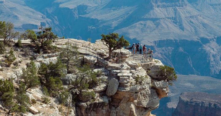
Now the road runs parallel to the new highway under the rocks of the Baidaro-Kastropol wall, past the Shaitan-Merdven pass, next to the ancient Pilyaki volcano. People travel along this road only for the sake of the Baydar Gate and the wonderful view from it of the Foros Church and the picturesque coast below it. The modern highway between Yalta and Sevastopol passes much lower, through the Laspinsky Pass, where a viewing platform is built on a powerful rock.
The rock bears the name and is decorated with a bas-relief of Garin-Mikhailovsky, a writer and a very talented railway engineer. Even a century later, his research and calculations were useful for the construction of this very road. The site offers a grandiose view of Laspi and Batiliman bays and Cape Aya.
The length of the old Sevastopol road is 15 km. The road in some places has been destroyed by landslides, and only certain sections of it can be used by cars. It is best to start traveling along it from Foros. At one of the turns of the road leading to the Baydarsky Pass, the highway goes to the right, this is the old Sevastopol road. It is almost horizontal, without steep ascents and descents and is perfect for hiking. Along the route there are three descents to the new highway - near the villages of Verkhniye Olive, Parkovoe, Opolznevoye.

The Roman military road, or Kalendskaya trail, named after the village of Kalenda, now Podgornoye. Leads to the Devil's Staircase. Via militaris connected Chersonesos with the fortress of Charax. The road was built in the 1st century AD. Roman legionaries. The remains of a Roman road 8 km long have been preserved to this day on the road to Kilse-Burun. Of these, 5.5 km are cut through strong limestone. The cart tracks are clearly visible. From the village Podgorny to the village. The wide road crossed the Baydar valley, climbed the slope of Mount Simnalykh and then led to the village. Morozovka. From there, along the right bank of the Chernaya River, along the Kara-Koba valley it led to Chersonesus.