Geographical position of the country
Montenegro is a state in southeastern Europe, on the Adriatic coast of the Balkan Peninsula.
Geographical coordinates:42 30 N, 19 18 E
The territory of the country has the shape of an irregular trapezoid with its top facing the sea. The length from north to south and from west to east is about 200 km, the Adriatic coast is about 100 km (not counting the coastline of the winding Bay of Kotor).
It is washed by the Adriatic Sea and has land borders with Croatia in the west, Bosnia and Herzegovina in the northwest, Serbia in the northeast, partially recognized by the Republic of Kosovo in the east and Albania in the southeast.
The country's territory can be conditionally divided into three parts: the coast of the Adriatic Sea, the relatively flat central part of the country, on which its two largest cities are located: Podgorica and Niksic, and the mountain systems of the east of the country.
The length of the state's land borders is 614 km: in the west with the Republic of Croatia - 14 km; in the northwest with Bosnia and Herzegovina - 225 km; in the northeast with the Republic of Serbia and Kosovo 203 km; in the southeast with the Republic of Albania - 172 km.
The continental coastline of Montenegro has a length of about 300 km. Montenegro has 14 sea islands, the total length of the coastline of which is 15.6 km. In the north-west of the country there is a large bay of Boka Kotorska, which has a water surface area of \u200b\u200b87.3 km² and cuts into the land for 29.6 km.
The length of the beaches of Montenegro is 73 km. The temperature of sea water for seven months ranges from + 12 to +26 ° C, the transparency of sea water in some places exceeds 35 m.
Country relief
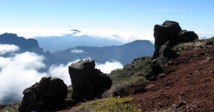
The Republic of Montenegro occupies the highest outskirts of the Dinaric Highlands, consisting of individual mountain ranges, ridges and intermontane basins. Here many peaks rise above 2000 m above sea level; in the south, on the border with Albania, there is the highest point of the country - Mount Jaravitsa (2656 m). The edge ridges of the highland have a steep dip towards the Adriatic Sea.
Some of the mountain ranges are a bare karst plateau, while others, and most of them, are covered with dense coniferous forests, which gave some philologists the right to deduce the name of the country from the blackness of mountain dark coniferous forests.
Rocky plateaus is a picturesque area of \u200b\u200bMontenegro, which literally adjoins the coast. Mountain and sea air currents meet here. This region is poorly populated. In the area above Kotor, precipitation reaches about 4800 mm per year: this is the highest indicator in Europe. Heavy showers can be observed here for many days.
Central Plain. Skadar Lake, the valley of the Zeta River and the plains in the area of \u200b\u200bthe largest cities of Montenegro Niksic, Danilovgrad and Podgorica. Its average height is 40 m (in the north, fertile lowlands and river valleys are an ideal place for settlements, therefore the largest number of the country's population is concentrated here. There are also the three largest cities in the country - Niksic and Podgorica and Danilovgrad, as well as the Skadarskoe National Park. The plains do not occupy too large areas. The region of Skadar Lake, the valley of the Zeta River and the Niksic field are well suited for agriculture. In fact, all the fertile lands of the country are limited to this, therefore Montenegro is by no means an agricultural country. The climate on the plain is very warm, the summer is warmer than in the subtropics of the seaside.Warm air masses come from the sea along the valley and reach Podgorica, therefore it is the warmest city in all of Montenegro.
Highlands. The north of Montenegro is covered with high mountains. These mountains are rich in pastures, forests and lakes. The rivers Moratsa, Piva, Tara and their tributaries cut canyons in the rocks - narrow channels with steep banks. There are two national parks in this region - Biogradsky and Durmitor. The highlands occupy the most significant area of \u200b\u200bthe country and are an important attraction. There are mountain plateaus surrounded on all sides at an altitude of 1400-1700 meters. They are separated by mountain peaks over 2000 meters high, including the highest mountain Bobotov Kuk located on the Durmitor massif - 2522 meters. In addition to the majestic mountains, the area is extremely attractive for its reservoirs. In total, Montenegro has 29 high-mountainous lakes of rare beauty. Mountain rivers such as Piva, Tara, Moraca, Zeta also flow here. Over the millions of years of their existence, these rivers, as well as their tributaries, have carved narrow channels with steep banks in the rocks - canyons, whose beauty and size are unique. The Tara River Canyon is the largest in Europe, its depth reaches 1300 meters. Only the Grand Canyon in Colorado is bigger than him. The Tara River, the purest European river, which is under the protection of UNESCO, is suitable for active tourism, for example, rafting.
Climate of Montenegro
Montenegro has a Mediterranean type of climate characterized by dry and hot summers and cool winters with abundant rainfall. Despite the fact that the territory of the country is small, 4 climatic regions can be distinguished here: the coast, the rocky plateau, the plain and the highlands.
A narrow strip, 2-10 km wide along the coast of Montenegro, has the most pronounced features of the Mediterranean climate. Summer is hot there (the average daily temperature in July is 28..30 o С), and there is little precipitation (25-50 mm per month). The rainy period lasts from November to January, at this time, 170-260 mm falls per month, in the north of the coast there is 1.5 times more precipitation than in the south. The average monthly temperature at night in January does not drop below 4..5 o С, and in the daytime 11..13 o С. The negative temperature is not observed every year. The swimming season lasts 5 months from the end of May to October, the water temperature is 20 ... 25 o С.
A rocky plateau separates the coast from the interior of the country. It receives the most rainfall in Europe, as its southwestern slopes trap the moist air coming from the sea. Thus, in the village of Krivosie, located above the Bay of Kotor, 480 mm of precipitation was recorded per day. In the town of Crkvice, the maximum annual rainfall was 5155 mm, and in the cultural capital of the country, Cetinje, located on the plateau near Mount Lovcen, the maximum average annual rainfall (3927 mm / year). Just like on the coast, precipitation in summer is noticeably less (60 - 80 mm in July), and November is the rainiest month (500 - 700 mm). The difference in altitude between the coast and the plateau is on average 1000 m, and the height of some peaks reaches 1700 m. Therefore, in summer it is cooler here than on the coast, the average daily temperature in July varies from 23 to 27 o С depending on the altitude. In winter, the average temperature at night is -3 ..- 5 o C, and in the daytime 5..8 o C. Snow usually falls in December and lasts until mid-March.
The plain is protected by a rocky plateau from the direct impact of the Adriatic Sea, so in summer it is hotter than on the coast (the average daytime temperature in July is 30 ... 32 o C), and in winter it is cooler: on average 0 ... 3 o C at night and 9 ... o Happy day. Precipitation occurs mainly in autumn and winter. In July, 30-60 mm of precipitation falls, and in November, 250-300 mm.
The climate of the high-mountainous regions is subalpine. In winter, the average temperature at night is -6 ..- 9 o С, and in the daytime 0..3 o С, but it decreases with height. Snow usually falls at the end of November and lasts until the end of March. Precipitation occurs evenly throughout the year, with a maximum in November (it can fall from 100 to 300 mm per month, depending on the orientation of the slope). Summers are cool, the average daytime temperature is 19 ... 23 o С (high in the mountains it can be colder!), And at night 8 ... 10 o С.
Rivers and lakes
The longest rivers in Montenegro are: Tara (144 km), Lim (123 km), Cheotina (100 km), Moraca (99 km), Zeta (65 km) and Boyana (30 km). About 52.2% of the Montenegrin rivers belong to the Black Sea basin, the remaining 47.8% - to the Adriatic Sea basin. Three Montenegrin rivers (Moraca, Zeta and Piva) flow along their entire length through the territory of Montenegro. The Boyana River was previously the only navigable river in Montenegro; it is not currently shipping. Most of the Montenegrin rivers are mountainous and form deep canyons. The Tara River Canyon, about 1200 m deep, is the deepest in Europe and the second deepest in the world. The rivers of Montenegro have an energy potential of 115 kW per 1 km² of territory, which is a very high indicator. However, for various reasons (including environmental), hydropower is not developed in the country.
The largest lake in Montenegro and the entire Balkan Peninsula is Skadar. The total area of \u200b\u200bits water surface is 369.7 km². Two thirds of the lake (by area) are located in Montenegro, one third - in Albania. 40 mountainous islands rise above the lake surface. The second largest lake in Montenegro is Shasskoe (3.64 km²), located near Ulcinj. Also on the territory of Montenegro there are 29 small mountain lakes of glacial origin (the so-called "mountain eyes"), the total area of \u200b\u200bwhich is 3.89 km². They are called "mountain eyes" because the water in them is unusually clear and calm. They not only resemble the eyes of nature in form and purity. In them, as in the eyes, lowered by the "eyelashes" of the needles, mountain peaks are reflected. The most beautiful of the lakes is Black Lake. Its area is 516,000 sq. meters, it is located at an altitude of 1,418 meters above sea level. Its clear water is visible to a depth of 9 meters. Black Lake consists of two lakes - Big and Small. During floods, the water of a large lake goes underground in the vicinity of Zabljak, passing a long way in depth, under the canyon of the Tara River, comes to the surface and becomes its right tributary. In the same way, the water leaving through the bottom of the Small Lake comes to the surface in the Komarnitsa canyon, and together with it flows into the Piva River. The Tara and Piva rivers, merging, form the Drina river. The Serpent Lake is located in a dense forest at an altitude of 1,495 meters, and Maloe Lake is 1,788 meters above sea level. Many legends are associated with each of the lakes, the names of which are translated as Fish, Blue, Wavy, Enemy, Green.
Vegetable world
Due to the mountainous relief and southern latitudes, the vegetation of this small republic is very diverse. On the territory of Montenegro, 1.2% of the world's flora grows, about 3500 plant species. The country ranks 1st in Europe in terms of the number of plant species per unit area. These are mainly rare, endemic and relict species, among which there are medicinal, aromatic and melliferous plants. Most of the territory (about 80%) is occupied by forests, where spruce, fir, beech, elm, oak, maple, mountain ash, lime grow. Meadows are also common. On the coast of the Adriatic Sea and islands - thickets of rigid-leaved evergreen shrubs (maquis) and areas of subtropical forests (from stone oak, laurel, myrtle, etc.); large areas are covered with tough grasses.
Due to the fact that the average height of Montenegro above sea level is 1500 m, a lot of light and ultraviolet rays fall on the plants, which is very important for the appearance of medicinal properties in them. From climatic factors, a significant amount of precipitation should be noted. Most of them fall out in spring and autumn.
Mountain plants are fed with moisture due to the night dew. On the other hand, summer dryness also has its effect, because promotes the formation of a large amount of oily substances. Soil composition also affects vegetation diversity.
Animal world
Thanks to the forests in Montenegro, a rich natural fauna has been preserved. Large animals are found in mountainous regions: brown bears, lynxes, wild boars, wolves, deer, fallow deer, chamois, and wild goats. Jackals on the coast, in karst areas - turtles, snakes, lizards. Lizards and snakes live on rocky slopes. The world of birds is also rich; woodpeckers, turtle doves, cuckoos, partridges, blackbirds live here. Numerous carnivores (golden eagle, vulture, etc.) are also widespread. Fish stocks, both marine and freshwater, are also significant. Carp, pike, perch, trout, eel are found in rivers and lakes. In the Adriatic Sea, sardine, mackerel, tuna, palamida, and mullet are of commercial importance.
Montenegro is one of the most popular tourist destinations in Europe. Montenegro is mountains and plains, dense forests, crystal-clear waters of the Adriatic, mountain rivers and picturesque lakes, piercingly clean air, as well as beautiful ancient cities where different styles and cultures are so harmoniously combined, thereby creating a unique flavor and atmosphere of comfort. The stunning natural wealth of this beautiful country, the wonderful climate, the abundance of historical, architectural and cultural attractions combined with affordable prices attract more and more tourists to this little paradise.
Lord George Byron wrote about Montenegro:
"At the moment of the birth of our planet, the most beautiful meeting of land and sea took place in Montenegro ... When the pearls of nature were sown, a whole handful fell on this land ..."
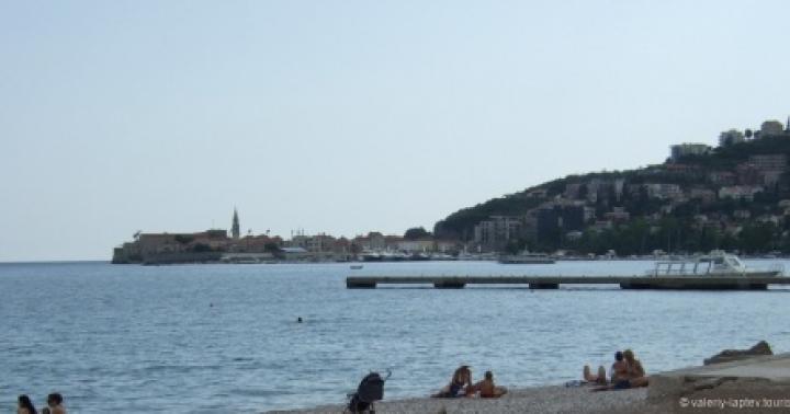
The Republic of Montenegro covers the southwestern, coastal part of the Balkan Peninsula. In the west, Montenegro borders on Croatia, in the north-west - with Bosnia and Herzegovina, in the north, north-east and east - with Serbia, in the south-east - with Albania. The population of Montenegro is about 650,000 people. The Montenegrin coast has a coastal part with a length of 293 km. Along the coast there are 14 islands with 15.6 km. coastline.  Budva is a city in Montenegro, located in the central part of the Adriatic coast of the country. The city is the center of the municipal district of the same name. Budva was founded 2500 years ago and is one of the most ancient settlements on the shores of the Adriatic Sea.
  Budva and its surroundings form the Budva Riviera, the largest tourist center in Montenegro, famous for its sandy beaches, nightlife and fine examples of Mediterranean architecture.
  Most of the historical monuments are concentrated in the Old Town of Budva. Located on a peninsula that juts out sharply into the sea, it is a corner of typical Venetian and Mediterranean architecture. Despite the devastating effects of the 1979 earthquake, by 1987 the Old Town was completely rebuilt. The old town is surrounded by a powerful fortress wall and is cut through by narrow winding streets that lead to the city citadel, where the museum is now located. There are three old churches near the citadel.
  The beautiful and graceful sculpture of the dancer, located on a rocky stone near the Mogren beach, has become the unofficial symbol of the city. This is the most famous and photographed landmark of Budva. This monument, according to legend, is associated with a romantic legend, and has become a symbol of true love, near which romantically inclined natures love to be photographed and make wishes.
  Fortress walls
  Fortress walls of Budva from the sea
  Cathedral of St. John the Baptist (founded in the 7th century), with a bell tower - the architectural dominant of the old city.
  The Church of the Holy Trinity (built in 1804) is an Orthodox church built in a typical Byzantine style. A characteristic feature is the spinning-wheel bell tower with three bells. The facade of the church above the western gate is decorated with a rosette. A Greek icon painter painted the iconostasis partition of this church in the 19th century, and it has exceptional artistic value.
  Citadel Budva (city fortress Kastel), built on a hill on the southern side of the city. Here the city walls begin and end. The fortress was first mentioned in 1425.
  Old town Budva
  Not far from Budva, within line of sight, is the island of St. Nikola, one of the few islands off the coast of Montenegro.
  Marina for yachts and boats near the Old Town of Budva
  Budva is surrounded by beaches, most of which are either coarse sand or small pebble.
  Ostrog Monastery is one of the most amazing and wonderful places in Montenegro. This is recognized by everyone who has visited it at least once. Carved into a cliff at an altitude of 900 meters above sea level, the monastery is the embodiment of purity, fortitude and true faith, for which nothing is impossible. Due to its unique architecture and location, Ostrog, like a guiding star in the dark sky, is always clearly visible from afar both day and night. Looking at him, sometimes it begins to seem that the construction of such a temple cannot be the work of human hands, but is the result of divine providence.
  Today Ostrog is an active Serbian Orthodox monastery in Montenegro, located in the mountains 15 km from the city of Danilovgrad, at an altitude of about 900 m above sea level. Founded in the 17th century. The monastery houses the relics of its founder, Saint Basil of Ostrog, one of the most revered saints of the Serbian Orthodox Church. The imperishable relics of St. Basil of Ostrog are still kept in one of the monastery churches, becoming one of the main Montenegrin relics. It is believed that these relics have miraculous healing powers.
  It is believed to be the third most visited place of Orthodox pilgrimage in the world, after the tomb of Christ and the holy mountain in Jerusalem. Ostrog is the only active Orthodox monastery, where not only Christians, but also followers of other religions come for pilgrimage purposes.
  Old Austrian fortress Kosmach. This fortress is perfectly visible from the Budva-Cetinje highway. The Kosmach Fortress was built by the Austrians as a defensive structure on the border with Montenegro, then a semi-autonomous province of the Ottoman Empire, in 1841-50. Located on the top of the Kosmach hill (hence its name). The fortress was a key one in the chain of border fortresses of Austria-Hungary.
  Sveti Stefan is a resort in Montenegro, located on the Adriatic coast, on the Budva Riviera, 5 kilometers southeast of Budva. It is located on a small island, a natural isthmus between the land and the island, appeared as a result of alluvial gravel layers. A very rare natural phenomenon. The island is closed to non-hotel guests. The village of the same name adjacent to the island has a tourist infrastructure, and the prices for apartments, although higher than the average in Montenegro, are much more affordable than in a hotel on the island.
  For the first time the fortress was mentioned in the annals of 1442, when the inhabitants of the local village of Petrovichi met the Ottomans who were trying to capture Kotor. After the victory, it was decided to erect a church and a fortress in honor of St. Stephen. Sveti Stefan was an important trade center and transport hub during the times of the Venetian Republic. Sveti Stefan was inhabited in the 15th century and for a long time was a simple fishing village. Due to the economic crisis, the city began to decline. In the 1950s, 20 residents were resettled to the mainland, and Sveti Stefan became a luxury hotel city. During the reconstruction, the appearance of the buildings, of which there are about 80, did not suffer. Holidays in Sveti Stefan were popular among many celebrities: at one time the guests of the resort were Elizabeth Taylor, Sophia Loren, Claudia Schiffer, Carlo Ponti, Kirk Douglas, Bobby Fischer, Sylvester Stallone other.
  Sveti Stefan Island is one of the most expensive resorts in Montenegro. There are 58 luxury apartments, including 8 in the world famous Milocer Villa. The beaches on the island have a total length of about 2 kilometers and consist of beautiful pink sand. The island is connected to the land by a small isthmus of reclaimed gravel layers, which is a unique phenomenon in itself - the isthmus is of natural, not artificial origin.
  Here is the cleanest sea in all of Europe and beaches with dark gray sand or the smallest pebbles.
  Boka Kotorska Bay is considered one of the most beautiful bays in the world and confidently ranks first among the most beautiful bays in Europe. Previously, it was even believed that the Bay of Kotor is the southernmost fjord in Europe. In fact, this is not the case, but the landscapes are really very similar.
  Kotor is a city in Montenegro, the administrative center of the Kotor Municipality. Located on the shores of the Bay of Kotor, the Adriatic Sea. Historically, Kotor and the surrounding lands belong to the Dalmatia region. The old part of the city is under the protection of UNESCO. Kotor is the administrative, cultural, religious, educational and economic center of Boka Kotorska. Throughout the history of Kotor and the Bay of Kotor, the main occupation of local residents was navigation and overseas trade. Therefore, Kotor has become one of the most important trade centers in this part of the Adriatic coast.
  The Cathedral of St. Tryphon in Kotor is the cathedral of the Catholic Diocese of Kotor. The Cathedral of St. Tryphon has become the center of the spiritual life of local Croats, historically constituting a significant part of the population of Kotor. This is one of two Catholic cathedrals in Montenegro, along with the Cathedral of the Immaculate Conception of the Virgin Mary, located in the city of Bar. The Cathedral of Saint Tryphon, despite numerous reconstructions, is an outstanding example of Romanesque architecture. The building of the cathedral was consecrated on July 19, 1166 in the name of St. Tryphon, who is considered the patron saint of Kotor. The building has faced many challenges; one of the most difficult moments in the history of the temple was the catastrophic earthquake of 1667. Its consequences were the destruction of part of the building, as a result of which both bell towers of the cathedral had to be rebuilt. Built of stone from the now Croatian island of Korcula, they acquired some of the characteristic baroque features. They were connected to each other by a wide arch dividing the facade of the building horizontally. On the upper part of the facade there is a fairly large rosette window; the arch forms a portico located directly above the entrance to the cathedral. St. Tryphon Cathedral is part of the World Heritage Site "Natural and Cultural-Historical Region of Kotor".
  In the northern part of the old Kotor, there is another building that attracts the attention of not only ordinary tourists, but also those who are interested in the history of Orthodoxy - this is the Church of St. Nicholas. The construction of the church began in 1902 on the foundations of a burnt-out building; construction was completed in 1909 - the date of completion of construction is imprinted on the facade of the building. The famous architect Chorill Ivekovic worked on the project of the temple. Built in the Byzantine style, with one nave and two bell towers on the main façade, the church is remarkably visible from the city wall, which adjoins it closely. The Church of St. Nicholas is the only Orthodox church in Kotor where services are held daily.
  The old town of Kotor is considered to be one of the best-preserved medieval urban centers on the Adriatic, included in the UNESCO World Heritage List. From 1420 to 1797, Kotor and its environs were under the rule of the Venetian Republic and Venetian influence remained dominant in the architecture of the city. The city walls were continuously built and rebuilt from the 9th to the 19th century. The walls surround the old town and rise to a rocky hill, on the slope of which is Kotor. Their length is 4.5 kilometers, their height reaches 20 meters, and their thickness is 16 meters. At the top of a hill at an altitude of 260 meters above sea level - the fortress of St. John
  The Kotor Fortress is one of the unique attractions. The construction of the citadel was started by the Romans, destroying the foundation and walls that the Illyrians had previously erected here. The next who seized this strategically important bay were the Byzantines: they destroyed the already dilapidated citadel and built a new one in its place. Further, the citadel of Kotor was influenced by many different invaders. The Byzantines in the middle of the 9th century were replaced by Arabs, followed by Bulgarians, Venetians and Serbs. During the Venetian rule (15-17 centuries) the Ottomans tried to besiege the fortress. In the 18th century. fortifications went to the Habsburgs, and at the beginning of the 19th century. - The French Empire. True, France did not have time to add something of its own to the appearance of the fortress: in 1814 the fortress was occupied by the British. By the decision of the Congress of Vienna, Kotor returned to the bosom of the Austrian Empire. In 1979 the fortress was included in the UNESCO World Heritage List.
  Fortress walls protect the old city from the north and southwest. Their length is 4.5 km, their thickness is from 2 to 16 m, and their height is 20 m. Amazing power! But the main reason why most of the tourists want to get here is 1460! steps (someone counted). To climb to the top of the mountain, directly to the fortress itself, you need to overcome them. And the path is thorny and long: the first part is the green path (easy), the second is yellow (medium difficulty), the third is red (the most difficult and dangerous). Some steps are destroyed, in some places the road goes directly over the cliff.
  View of the city walls from the river.
  Perast is an ancient city in Montenegro. Located on the shores of the Bay of Kotor, the Adriatic Sea, a few kilometers northwest of Kotor. Perast lies at the foot of St. Elijah's Hill (873 m), on a promontory that separates the Risan Bay from the Bay of Kotor (which, in turn, are part of the Bay of Kotor), directly opposite the Verige Strait, the narrowest part of Boka.
 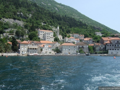 The name of the city is believed to be derived from the name of the Illyrian Pirust tribe. Traces of a Neolithic culture (circa 3500 BC) were found in the Spila Cave above Perast. Various archaeological evidence of the Illyrian, Roman and early Christian periods have also been found here. Founded by the Illyrians. Despite its small size, Perast is immensely popular among tourists as it is one of the most beautiful examples of Baroque architecture on the shores of the Adriatic. Each house in the city, and there are not so few of them, is like a real museum, and the surrounding beauty of the bay gives Perast even more charm. According to the 2003 census, the city has 349 inhabitants
  There are two small islands near Perast: St. George Island and Gospa od Shkrpela Island
  One of the islands is called the island of St. George, on which stands a picturesque Benedictine abbey, which was first mentioned in 1166 as the property of the city of Kotor. Examination of the few surviving fragments of the original architectural decoration led to the conclusion that the abbey existed at least as early as the 9th century. The island remained Kotor's possession until 1634, when the Venetian Senate passed the patronage over it. The island was constantly threatened by invasions and earthquakes. In 1535, the townspeople of Perast killed Abbot Pascal, who was elected by the city council of Kotor (as a sign of repentance, the people of Perast rebuilt and expanded the church on a neighboring island). In 1571, the Turkish pirate Caradoz burned both the abbey and the entire Perast (restoration began only in 1603). During the Great Earthquake on April 6, 1667, the Abbey on St. George Island was destroyed again. In 1812, the abbey was captured by the French, who were later expelled by the townspeople of Perast. In 1814 the abbey was taken over by the Austrians. The abbey houses the works of the 15th century by Lovro Marinov Dobrichevich, a famous artist from Kotor.
  Another island is called "Gospa od Skrpela" (Italian Madonna dello Scarpello, which means "Madonna on the Reef" or "Mother of God on the Rock" (from the Latin "scropulus" - "reef"). Gospa od Skrpela is perhaps the only man-made the island of the Adriatic and is located 115 meters north-west of the island of St. George.It was built on top of the reef after in 1452 two sailors from Perast, the Mortesici brothers, found on it an icon of the Mother of God, which healed one of them from illness After that, the icon immediately became venerated.Initially the reef was only slightly above the surface of the water, but the townspeople for 200 years flooded the captured pirate and their old ships next to it (in addition, a law was passed according to which every ship passing by the reef had to to throw a stone on the bottom here.) Thus, a plateau was created, the area of \u200b\u200bwhich is 3030 m2.
  The Church of the Mother of God was built on the island (it took its modern form after the reconstruction undertaken after the Great Earthquake on April 6, 1667). The church was built in the Byzantine style and is 11 meters high. It is believed that the inhabitants of Perast built the church not only because they wanted to see the Virgin Mary as the patroness of their sailors, but also to secure their power over the man-made island, as opposed to Kotor's power over the island of St. George. At the end of the 17th century, Perast reached the peak of economic and cultural development, which helped to decorate the Church of the Mother of God on the Rock with many works of art. So, Andriya Zmaevich invited Tripo Kokol to decorate it, who spent about 10 years to complete the painting of the church. For centuries, the church received gifts from wealthy townspeople and ship captains and is now not only a temple, but also a treasury and an art gallery. There are 68 oil paintings here. On the walls of the church, you can see 2500 gold and silver "vow" plates, which the inhabitants of Boka Kotorska donated to the church "in fulfillment of this vow" for deliverance from various disasters.
  The canyons of the Tara and Moraca rivers are the most amazing corner of Montenegro. In our opinion, this particular excursion is considered the most interesting in Montenegro. For almost fourteen hours we traveled by bus along the winding Montenegrin serpentines. To fly to Montenegro and not go to see the canyons is almost the same as never going to the beach. In the photo - Moraca River Canyon.
  Around each turn, truly amazing mountain landscapes and fantastic views of the rivers running somewhere far below opened up. Well, what can we say - the nature in Montenegro is simply amazing.

 Lake Biogradsko is often called the heart of the Biogradska Gora National Park - it really is its central part and the most attractive destination for tourists visiting the region. This unique nature reserve, one of the most beautiful lakes of the entire Balkan Peninsula, is able to give a lot of pleasant impressions from the dense forests surrounding it, clean mountain air and clear blue water, which have remained unchanged for several centuries.
  Lake Biogradskoe is located in an intermountain basin of glacial origin at an altitude of 1,094 m above sea level. It is the largest of the 6 lakes scattered throughout the Biogradska Gora National Park. The surface area is 228,500 m², the average depth is 4.5 m, and the maximum depth is 12.1 m. The Lavel stream and the Biogradskaya river flow into the lake. From Lake Biogradskoe flows the Jezerstica River, which is a tributary of the Tara.
  Montenegro is famous for its many beautiful places. One of them is the Tara River Canyon, the deepest in Europe and the second in the world after the Grand Canyon! All around are beautiful mountains, gorges and waterfalls. The length of this miracle of nature is 82 km, in some places the height of the walls reaches more than 1300 meters.
  Huge massive mountains seem to hang over your head.
  One of the most beautiful places in the Tara canyon is the river bend. At this point, it bends in the form of a huge horseshoe.
 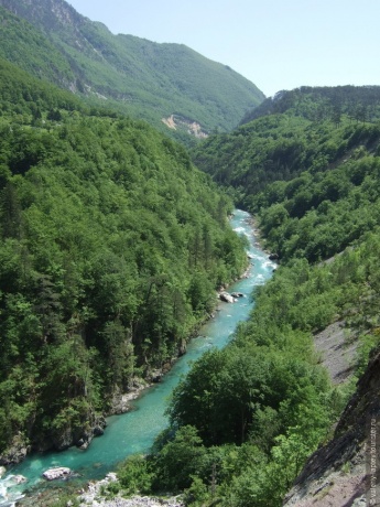 The canyon is located between the Sinjaevina and Durmitor mountains on one side, and Lyubishnya and Zlatni Bor on the other, being part of the Durmitor national park. The territory of the canyon with the Durmitor park is included in the UNESCO World Heritage List.
  It is simply impossible to tell about the number of amazing landscapes that we managed to see. Not a single photo in any way conveys the fantastic beauty of this place, in any description it seems faded in comparison with reality.
  The Djurjevic Bridge is a concrete arched bridge across the Tara River in northern Montenegro. Located at the crossroads between the towns of Mojkovac, Zabljak and Pljevlja. The Djurdzhevich Bridge got its name from the name of the owner of the farm, which is located nearby. The Djurdjevic Bridge was designed by Miyat Troyanovich. It was built between 1937 and 1940 in the Kingdom of Yugoslavia. The chief project engineer is Isaac Russo. The 5-arch bridge is 365 meters long, the longest span is 116 meters. The height of the roadway of the bridge from the Tara River is 172 meters. At the time of completion, it was the largest road concrete arch bridge in Europe. The bridge has become the country's trademark.
 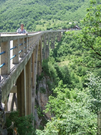 Yugoslav partisans in 1942, with the help of one of the bridge construction engineers - Lazar Yaukovich - blew up the central arch, and preserved the rest of the spans. The explosion of the longest span destroyed the only crossing of the Tara River canyon in the area, which led to a halt in the Italian offensive in this part of Montenegro. The Italians got so angry that they specifically looked for Lazar Yaukovich, and in the end he was captured and shot. A monument to the engineer stands at the entrance to the bridge. These events were depicted in the 1969 Yugoslav film The Bridge and the British film Hurricane from Navarone. The bridge was rebuilt in 1946. Excursion buses constantly come to it. For everyone on the Djurdjevic Bridge there is a camping with a parking lot, a shop, a hostel and a gas station.
  A magnificent view opens from the Djurdjevic Bridge. Feeling like you're floating in the air. There is a huge abyss under your feet and somewhere far below the waves of Tara are seething.
  Around the mountains, cliffs, forest, clean air ... joy in the soul from this extraordinary beauty!
 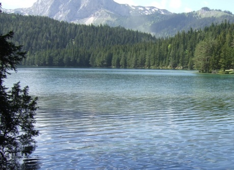 Durmitor National Park is a real miracle of nature in Montenegro. Ancient forests, mountains, lakes, rivers and alpine meadows are spread over a vast area. Somewhere here are lost small villages, people in which live almost the same way as many hundreds of years ago, without changing the centuries-old way of life. Durmitor is confidently included in the list of the most interesting sights of Montenegro. The Durmitor National Park, established in 1952, includes the Durmitor mountain range, the canyons of the Tara, Sushitsa and Draga rivers, as well as the upper part of the Komarnitsa plateau. The total area is 390 km². In 1980 it was included in the UNESCO World Heritage List.
  Some believe that the word "durmitor" comes from the Celtic language and means - "mountains in which there are many waters", others - that from Latin this word means "sleeping, immersed in eternal sleep." During the Ice Age, everything here was covered with ice, and with the arrival of the thaw, many beautiful mountain lakes were formed. There are about 18 of them; the most famous of them is the Black Lake ("Crno Jezero"), which the locals call "black eyes", because a large lake flows into a small lake across the isthmus and forms a semblance of eyes.
 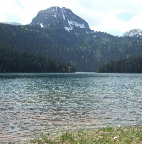 In addition to lakes, Durmitor is famous for its mountain peaks, some of which are covered with snow even in summer. The highest point of the mountain range is Bobotov Kuk; its height is 2523 m. This Peak has a strange but euphonious name and is said to be the highest mountain peak in the Republic of Montenegro. It is one of 48 peaks with heights of over 2000 meters, located on the territory of the Durmitor mountain range.
  Black Lake is comfortably located at the foot of the Bobotov Kuk Mountain at an altitude of 1416 m. Its area is 516 m². The water in the lake is of high purity and transparency, you can drink it without fear. The water in the lake is so clear that it can be seen at a depth of 9 meters. In fact, it consists of two small bodies of water - the Big and the Small, connected by a narrow strait. Among other things, Black Lake is also very beautiful - a dense coniferous forest is reflected in its calm waters, which gives the reservoir a rich blue-green color.
  Durmitor is the embodiment of a real fairy tale. There are ice lakes, and spacious meadows covered with a variety of flowers, and thickets of dense coniferous forest, where you can always hear the singing of birds and see squirrels jumping along the branches.
 The terrain of Montenegro is not conducive to the appearance of wide, flat autobahns - most of the country is covered with mountains and hills, along which narrow serpentines and mountain roads are laid. These very roads in Montenegro, in the mountainous terrain, are a real test for the driver and passengers - a lot of extreme impressions from the trip are guaranteed!
  Skadar Lake is one of the main attractions of Montenegro. Skadar Lake or Shkoder is the largest lake on the Balkan Peninsula. Located on the territory of the two states Montenegro and Albania, 2/3 of the lake belongs to Montenegro. In 1983, Lake Skadar became a national park, this place is very beautiful, rich in fish and a huge number of birds, and there are numerous small villages on the coast. This is the largest natural freshwater body of water in the entire Balkan Peninsula - its average area is 475 square kilometers!
  Lake reeds, southern reeds and narrow-leaved cattails, white water lilies, yellow pods and chilim grow on the lake. The lake is rich in fish and waterfowl. Bleaks, carp, podust, freshwater eels, noble salmon, roach, shad, pachychilons, mullet and rudd are widespread. Birds are represented by no less than 26 species. In winter, more than 200 thousand birds live on the lake.
  The lake's water surface is about 390 km², but it can increase to 530 km² in winter floods. The average area is 475 km². The total length of the coast is 168 km: 110.5 km in Montenegro and 57.5 km in Albania. The maximum depth of the lake is over 60 meters, the average is 6 meters.
  The climate in the area of \u200b\u200bthe lake is Mediterranean, with mild and rainy winters. The average January temperature is 7.3 ° C. Summers are dry and hot, the air is heated above 40 ° C, the water is above 27 ° C
  Skadar Lake has a rich history and culture, as evidenced by numerous archaeological finds, medieval monasteries and churches, fortresses and local architecture (fishing villages, bridges, mills and wells). On the lake islands, of which there are only 55, and on the shore, by the lake, there are many interesting historical sights and monuments, including old churches and operating monasteries (Vranina, Starchevo, Beshka, Morachnik and others).
 The lake has been a protected National Park since 1983 and in 1996 was included in the List of Wetlands of International Importance by the 1971 Ramsar Convention.
  Cetinje Monastery is an Orthodox monastery of the Nativity of the Blessed Virgin Mary in the historical and spiritual capital of Montenegro, the city of Cetinje. The monastery was built in 1484. The main shrine kept in the monastery is the imperishable right hand of St. John the Baptist. This is one of the most revered shrines of the Christian world, since according to the Bible, John the Baptist laid his right hand on the head of Jesus Christ during Baptism.
  Church of the Nativity of the Virgin on Chipur.
  The village of Njegushi is a quiet, peaceful place, which is located on the slope of Mount Lovcen at an altitude of 900 m above sea level in the municipality of Cetinje. Now the village has turned into a real tourist town, in which there are no more than 50 houses and about 200 people. This settlement is known for producing the famous throughout Montenegro Negus prosciutto (dried pork ham), as well as famous homemade cheeses and natural mountain honey. Here you can also see how this meat is made, buy it as a souvenir or try prosciutto in local konoba. The fact is that it is here that nature itself has created ideal conditions for making prosciutto - a cool climate and mountain air that mixes with the sea. This is what gives the unique flavor to prosciutto from Njegusi.
  Montenegro is very rich in the most amazing sights. Here you can see not only magnificent natural landscapes, but also ancient churches, temples, fortresses. Even the most successful photographs in no way convey the beauty that we will remember for a lifetime. No wonder Vladimir Semyonovich Vysotsky wrote: "One birth is not enough for me, I would grow from two roots, It's a pity that Montenegro did not become my second homeland ..."
The explorer of the World Ocean Jacques-Yves Cousteau considered the coast of the Adriatic Sea, washing the coast of Montenegro, one of the cleanest in Europe. Along with ordinary tourists, this mountainous country is also preferred by such celebrities as Bill Gates, Angelina Jolie and Brad Pitt. Today, Montenegro is a unique reserve, a place where civilization harmoniously coexists with untouched nature, where the sea sparkles, medieval buildings peep among the greenery of the mountains and flowers are everywhere!
Geographical position of Montenegro
Montenegro is located in the central Mediterranean, in the southwestern part of the Balkan Peninsula. It is bordered by Croatia to the north, Bosnia and Herzegovina to the northwest, Serbia to the northeast, and Albania to the southeast. The length of the coastline is 293 km. The length of the beaches is 73 km. The part of the Adriatic Sea between Montenegro and Southern Italy is the widest (200 km) and the deepest (1330 m). Area: 13,812 sq. Km (0.14% of the entire territory of Europe).
Capital
Podgorica (173 thousand people) is the administrative center of the Republic of Montenegro. Cetinje is an ancient capital, historical and cultural center.
Climate in Montenegro
The variety of topography greatly influences the climate. A giant mountain range blocks the coast from the north winds. Therefore, the sea is dominated by the Mediterranean climate, and in the mountains - continental. The average annual air temperature in Montenegro is + 17 ° C, and in July and August + 29 ° C. The swimming season in Montenegro begins in April and lasts until November. The sea temperature for seven months ranges from +20 to + 26 ° C.
Population
620 st. people (in the spring of 2011). 62% Montenegrins, 13% Bosniaks, 9% Serbs, 7% Albanians
State structure
Republic of Montenegro
Language in Montenegro
Serbian (alphabet - Cyrillic and Latin). All Montenegrins understand Russian perfectly.
Religion in Montenegro
Montenegrins and Serbs profess Orthodoxy, national minorities - Catholicism and Islam.
Customs
You can import and export an unlimited amount of foreign currency into the country, but it is advisable to declare large amounts at the entrance. It should be noted that border and customs procedures are simplified as much as possible. You can import and export 200 cigarettes or 50 cigars, a liter of spirits and 2 liters of wine duty-free. The export of objects and things of historical and artistic value is prohibited - without special permission.
Car rent
To rent a car in Montenegro, you need to be at least 21 years old, have a driving experience of at least two years (plus, of course, an international certificate), and also leave a deposit of 150-300 euros. Speed \u200b\u200b- 40 km / h - in settlements, 70 km / h - on the highway, 120 km / h - on the autobahn.
Money in Montenegro
Euro. 1 euro \u003d 100 cents.
Banks work
On weekdays from 08:00 to 19:00, on Saturday from 08:00 to 15:00
Serbia and Montenegro dialing code
Necessary phones
Police - 92, fire brigade - 93, ambulance - 94, roadside assistance - 987. Codes of some cities: Herceg Novi and Igalo - 88, Budva, Becici, Petrovac, Milocer and Sveti Stefan - 86, Bar, Sutomore, Ulcinj , Ada-Boyana - 85, Tivat - 82
mobile connection
Works in the GSM standard, so you can use roaming. But it is more convenient and profitable to buy a card from one of the local operators - Pro Monte or Monet. There is no noticeable difference between them, express - payment cards for account replenishment are sold in any mini - market.
Electricity national parks
Durmitor (39.000 ha), Lovcen (6.400 ha), Biogradskaya Gora (5.400 ha). World natural and cultural heritage is protected by UNESCO.
Beach
The beaches in Montenegro are some of the best in the world, and thanks to their variety, you can choose a vacation by the sea for every taste. There are areas with fine sand (Ulcinj Riviera, Budva Riviera), most of them (Zhanits, Nivits, Sutomore) - with very small pebbles, the size of buckwheat. Artificial beaches (concrete platform) are located in Tivat, Herceg Novi, Bar, Igalo. There are very crowded beaches, and there are secluded ones, there are beaches for "textile workers" and for nudists, there are paid and free ones. Almost all beaches are located in secluded bays, sheltered from wind and waves, between steep cliffs. The length of the sea coast of Montenegro is 299 km, and the length of the beaches is 73 km. Renting umbrellas and sun loungers will cost 5-7 EUR per day. As a rule, guests of 4-5 star hotels use umbrellas and sun loungers for free. The largest beach ("Velika Plaza") is located in Ulcinj, its length is 13 km.
Montenegrin cuisine
Local cuisine is divided into 3 types - purely local, fish and Italian. The portions are huge. Despite the proximity of the Adriatic Sea, fish cuisine in Montenegro is very expensive. Local cuisine is a "fairy tale" of pork or beef. The cost of a dinner with wine for 2 persons varies from 12 to 20 euros. If it is a fish dish, then the cost of lunch will be from 20 to 30 euros. In many Montenegrin restaurants, after the third visit to the restaurant, guests can be fed for the fourth time at the expense of the institution.
The shops
Supermarkets and supermarkets are open daily from 06:00 to 21:00. Other shops from 09:00 to 21:00. In tourist centers, almost all shops are open until 23:00, and some are open on Sundays. With souvenirs in the country "tension", the whole choice - national costumes and hats (rather expensive and purely decorative), T-shirts with a map of the country and the inscription Montenegro, bottles, plates and various dishes made of handmade wood, lace, musical instruments (gusli, pipes), icons (reproductions) - mainly in monasteries, painting and sculpture.
Safety
The crime rate in Montenegro is relatively low. Petty thefts from cars, parked in unguarded parking lots, happen. The attitude towards foreigners is very friendly. In tourist areas, you can safely be in the evening. A large number of Albanians live in the mountainous and border areas. Visiting such places, especially where tourism is poorly developed, is not recommended without local accompaniment. You must follow basic precautions and heed your guide's recommendations.
Transport
All cities and large settlements are connected by bus service. During the tourist season, bus stations are open around the clock. Buses to Belgrade run regularly from Podgorica. In Herceg Novi and other towns on the coast, there is a bus connection with Croatia. From Ulcinj, a bus leaves once a day for the city of Shkoder in Albania. There is almost no intracity bus service in Montenegro, except for Podgorica. Short distances allow walking, taking a cheap taxi.
Souvenirs and shopping
As a souvenir you can buy national costumes and hats (rather expensive and purely decorative), T-shirts with a map of the country and the inscription Montenegro, bottles, plates and various dishes made of handmade wood, lace, musical instruments (gusli, pipes), reproductions of famous icons (in mostly in monasteries), painting and sculpture.
sights
It is in Montenegro that the largest lake in the Balkans is located - Skadar. 40 islands give it a special charm, some of them have perfectly preserved medieval fortresses and monasteries. By the way, Skadar Lake is one of the few where you can observe pelicans in their natural habitat.
In the Cetinje Monastery, there are two of the most important Orthodox shrines - a particle of the Holy Life-giving Cross of the Lord, on which Jesus Christ was crucified, and the right hand of the prophet Ion the Forerunner.
- a state in Southern Europe, located on the Balkan Peninsula. In the southeast it borders on Albania, in the south it is separated from Italy by the Adriatic Sea, in the west it has borders with Croatia and Bosnia and Herzegovina. The length of the sea coast of Montenegro (including the Malent Islands) is 293.5 km.
The name comes from the toponym Black Mountain.
Official name: Montenegro (Crna Gora).
Capital: Podgorica
The area of \u200b\u200bthe land: 13 812 sq. km
Total population: 620 K people
Administrative division: Montenegro is divided into 21 communities.
Form of government: Republic.
Head of State: The president.
Population composition: 57% are Montenegrins, 30,% are Serbs, 7.77% are Bosnians, 3% are Albanians, 1% are Russians, 0.42% are Roma.
Official language: Montenegrin. Serbian, Croatian, Bosnian and Albanian are also recognized as official languages.
Religion: 74.24% are Orthodox, 17.74% are Muslim, 3.54% are Catholics.
Internet domain: .me
Mains voltage: ~ 230 V, 50 Hz
Country dialing code: +382
Country barcode: 389
Climate

Montenegro has a Mediterranean type of climate characterized by dry and hot summers and cool winters with abundant rainfall. Despite the fact that the territory of the country is small, 4 climatic regions can be distinguished here: the coast, the rocky plateau, the plain and the highlands.
A narrow strip, 2-10 km wide along the coast of Montenegro, has the most pronounced features of the Mediterranean climate. Summer is hot there (the average daily temperature in July is 28..30 C), and there is little precipitation (25-50 mm per month). The rainy period lasts from November to January, at this time, 170-260 mm falls per month, in the north of the coast there is 1.5 times more precipitation than in the south. Average monthly temperature at night in January does not drop below 4..5 C, and in the daytime 11..13 C. Subzero temperatures are not observed every year. The swimming season lasts 5 months from the end of May to October, the water temperature is 20-25 C.
A rocky plateau separates the coast from the interior of the country. It receives the most rainfall in Europe, as its southwestern slopes trap the moist air coming from the sea. Thus, in the village of Krivosie, located above the Bay of Kotor, 480 mm of precipitation was recorded per day. In the town of Crkvice, the maximum annual rainfall was 5155 mm, and in the cultural capital of the country, Cetinje, located on the plateau near Mount Lovcen, the maximum average annual rainfall (3927 mm / year). Just like on the coast, precipitation in summer is noticeably less (60 - 80 mm in July), and November is the rainiest month (500 - 700 mm).
The difference in altitude between the coast and the plateau is on average 1000 m, and the height of some peaks reaches 1700 m. Therefore, in summer it is cooler here than on the coast, the average daily temperature in July varies from 23 to 27 C depending on the altitude. In winter, the average temperature at night is -3 ..- 5 C, and in the daytime 5..8 C. Snow usually falls in December and lasts until mid-March.
The plain is protected by a rocky plateau from the direct influence of the Adriatic Sea, therefore it is hotter here in summer than on the coast (average daytime temperature in July is 30..32oС), and in winter it is cooler: on average 0..3oС at night and 9..11oС during the day. Precipitation occurs mainly in autumn and winter. In July there is 30 - 60 mm of precipitation, and in November 250 - 300 mm.
The climate of the high-mountainous regions is subalpine. In winter, the average temperature at night is -6 ..- 9 C, and in the daytime 0..3 C, but it decreases with height. Snow usually falls at the end of November and lasts until the end of March. Precipitation occurs evenly throughout the year, with a maximum in November (it can fall from 100 to 300 mm per month, depending on the orientation of the slope). Summer is cool, the average daytime temperature is 19 ... 23 C (high in the mountains it can be colder!), And at night 8 ... 10 C.
Best time to visit:
For a beach holiday, July and August are best suited - the hottest, driest and sunniest months. In September, when the sea is still warm, and the main wave of tourists has already subsided, you can also have a great rest at the sea. Diving, windsurfing, paragliding and other sports, as well as sights can be practiced almost all year round, except November-December. You can safely go on a trip to mountainous regions from April to October. The ski season lasts from December to March.
Geography

Montenegro is a small country located in the southwestern part of the Balkan Peninsula on the Adriatic coast. Its area is only 13.8 thousand km2. Nevertheless, on the territory of the country, 4 different natural and climatic regions can be distinguished: coastal, plateau, highlands and plain, overlooking Lake Skadar.
In the west, Montenegro borders with Bosnia and Herzegovina, on the coast - with Croatia, in the north and north-east - with Serbia, and in the east - with Albania. From the south it is bounded by the Adriatic Sea; the coastline is about 300 km. The length of the beaches is 73 km, of which 56 km are sandy beaches.
The coast of Montenegro, only 2-10 km wide, is sandwiched between the sea and a rocky plateau that abruptly drops off to it. Montenegro has one of the best harbors in Europe - the Bay of Kotor (juts into the coast for more than 20 km), consisting of several spacious bays, connected by narrow channels. For a long time there was a belief that the bay is a fjord, but now it is believed that the Bay of Kotor is the remains of a river canyon that once existed here. Strong tectonic and karst processes led to its gradual destruction.
A karst plateau rises above the coast, the terrain is harsh, but beautiful in its own way. Rocks dry out quickly: even the strongest annual rainfall cannot significantly moisten the soil, so there are few plants and animals here. Rare areas of fertile land are found only on small plains and crater-like depressions. The Lovcen National Park is located here.
The basin of Lake Skadar, the fertile plain of the Zeta River, the Belopavlitskaya plain and the Niksic field make up a flat area with a height difference of 350 m. The main part of the population of Montenegro lives in the plain area. Here are the two largest cities of the country - Podgorica and Niksic, as well as the National Park "Skadar Lake".
In the north of the country, northeast of the rivers Piva, Komarnitsa and Moraca, there is a highland region. In the highlands, 4 large mountain ranges can be distinguished: Visitor, Durmitor and Komovi (they form the Dinari Highlands) and Prokletie (Cursed Mountains). The height of the peaks reaches over 2000 m above sea level. The highest point of Montenegro - Mount Bobotov Kuk (2522 m) is located in the Durmitor massif.
In the highlands, there are pastures and forests, numerous mountain lakes. The rivers Piva, Tara, Moraca and their tributaries cut narrow canyons with steep banks in the rocks. The Tara River Canyon is the largest in Europe and the second in the world, its depth reaches 1300 m. There are also two national parks in this region - Biogradska Gora and Durmitor.
Flora and fauna

Vegetable world
The flora of Montenegro is very rich, despite the harsh conditions in the mountainous regions that occupy most of the country. Here, only 0.14% of the territory of Europe, 2833 plant species grow, which is almost a quarter of the European flora species. On the coast you can find olive and fruit groves, cypresses, palms and grapes. However, most of the coastal cliffs are covered with maquis - dense thickets of evergreen shrubs typical of the Mediterranean.
Higher in the mountains there are oak and coniferous forests. The Belasitsa mountain range, where the Biogradska Gora national park is located, is covered with mixed forest. There are 86 species of trees, including spruce, fir, beech, elm, oak, maple and even mountain ash. Alpine edelweiss, which have become rare, grow in the mountains, as well as mountain cornflowers and violets, such vegetation is characteristic of the belt of alpine meadows.
In the area of \u200b\u200banother national park "Skadar Lake", the area is completely different. The main part of its coast is swampy, overgrown with reeds, and the surface of the lake is covered with a carpet of yellow and white water lilies. Many types of vegetation are endemic, i.e. found only in this area.
Animal world
The fauna of Montenegro is also rich. Wolves, bears, foxes are among the predators in mountainous areas. Deer, fallow deer, chamois, wild goats, hares and gophers serve as prey. Wild boars are found in the valleys. Several hundred species of fish are found in the Adriatic Sea, including sea bass, mullet, red mullet, as well as shrimp, lobster, octopus.

The rivers are rich in trout, perch, carp, catfish, carp and pike. There are 50 species of fish in Skadar Lake, the local population mainly trades bleak and carp. In addition, Lake Skadar is a permanent or temporary habitat for 270 bird species. Colonies of pelicans, cormorants, herons and black ibises can be seen here. The lake attracts bird watchers from all over the world.
sights

Many historical and cultural monuments have been preserved on the territory of Montenegro, and most of them, despite the numerous wars that swept through this land, are in excellent condition. Hundreds of medieval monasteries and ancient cities, dozens of balneological resorts, unique natural complexes of the southern part of the Balkans, tens of kilometers of beaches of the Montenegrin Riviera, good-natured and friendly people - this is not a complete list of the advantages of this country.
Montenegro and in the time of the united Yugoslavia was the main tourist region of the country. Due to the varied relief, the purest mountain rivers, the warm sea (which, by the way, is considered the cleanest in Europe), the luxurious coastline (the length is 290 km, the beaches are 73 km, and 56 km of them are sandy, which is quite rare for this region), excellent climate and the status of a European ecological park, this tiny country is one of the recognized centers of tourism in Europe.
Banks and currency

Monetary unit - euro (coins 1, 2, 5, 10, 20, 50 euro cents, 1 and 2 euros; bills of 5, 10, 20, 50, 100, 200, 500 euros).
The National Bank of Montenegro works from Monday to Friday (10: 30-14: 00). Commercial banks work from 08:00 to 19:00, on Saturdays - from 08:00 to 13:00, Sunday is a day off. On weekends, you can use exchange offices. There are many ATMs in Montenegro, through which you can carry out transactions with foreign currency. ATM machines are installed in banks, airports and in some hotels. Some shops and hotels accept credit card payments. You can always find several employees in the bank who speak English or Russian.
Useful information for tourists

Montenegrins are extremely tolerant of manifestations of interethnic differences, even to the issue of interethnic conflicts in the Balkans. But it is not recommended to talk about politics or the collapse of the SFRY.
The crime rate is low. The police harshly suppress any manifestations of deception of foreign tourists, but at the household level there are frequent cases of petty fraud or an allegedly suddenly appeared language barrier, so you should be especially careful when discussing financial issues and never give money in advance, before providing a service.
Tipping in restaurants is generally 5% of the bill.
It is better to use mineral or bottled water for drinking.
The price level in the country is quite low, but it differs markedly depending on the location. In coastal areas, everything is about 25% more expensive.
Montenegro is renowned for its diverse natural landscapes, especially inland. However, tourists are mostly interested in the main coast of Montenegro. We will talk about him in this article.
The length of the coast of Montenegro is 293 km. It consists of two separate parts: Boka Kotorska in the north (Bay of Kotor, a series of four basins connected by straits and surrounded by hills) and the "usual" coast in the south.
On the northern and eastern edge of the Bay of Kotor, the mountains rise almost vertically from the sea to the peaks Oriyen (1895 m) and Lovcen (1749 m). Warm air from the sea rises over the rocks, cools quickly and causes rain. Due to the abundant rainfall, the entire coast of the bay remains very green even during the warmest summer months. The vicinity of the Bay of Kotor is one of the regions in Europe with the highest rainfall.
The rest of the coastline is open to the sea. There are many long and relatively wide beaches. The region is dominated by Mediterranean vegetation with dense evergreen bushes and many aromatic plants. Tall cypresses, sea pines and olive groves are also common on the southern coast of Montenegro.
As for the weather on this coast, the summer is long and hot, and the winters are mild and rainy.
Montenegro coast map


Unfortunately, we could not find a good map of the Montenegrin coast in Russian, but we did find several detailed maps showing all the important cities and resorts of Montenegro on the Adriatic coast. We recommend that you enlarge the map to see it in more detail. To enlarge, click on the map itself, and then on the "Zoom" icon.