Climbing Belukha peak August 9th, 2009
Current Music: winds
General information: length - 112 km (actually more); difficulty category - 3b, 3a; distance from Barnaul - 735 km; 12 walking days + 2 road days. Altitude Belukha west. - 4506m above sea level! The number of groups that reached the summit is 2!
The travel package included the following items:
- Transfer Barnaul - Tungur village. We hire horses to Lake Akkem to transport equipment;
- Tyungur village - Kucherla village - Kara-Turek lane - "Meteorological Station" parking lot or "Kedrovaya" parking lot;
- Kara-Turek lane - Akkem lake;
- Training day. Customization of personal equipment. Basic skills training;
- Lake Akkem - "Tomsk sites";
- Training day. Ice activities on the Watermelon glacier. Hanging up the Delaunay pass;
- "Tomsk sites" - "Berel saddle";
- Reserve day in case of bad weather;
- Climbing Mount Belukha and descending to the “Tomsk sites”;
- "Tomsk sites" - Lake Akkem, bathhouse;
- Day. Day of rest. Radial exits are possible (Yarlu Valley/Valley of the Seven Lakes/Edelweiss Valley);
- Akkem lake - Akkem river;
- Akkem river - "Three Birches" parking lot - Kuzuyak lane - Kucherla village - Tyungur village;
- Transfer Tungur - Barnaul.
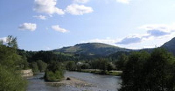
The approach to Lake Akkem takes 3 days through the Kara-Turek pass: beautiful, picturesque, tiring. At the lake we check in with Barnaul rescuers, wash in the bathhouse, adjust equipment, teach participants how to hold zhumars (rope clamps) and how to thread figure eights (descenders).
“Members,” as international-class rescuers call them, are complete beginners. They know about mountaineering from books, some even went to Elbrus, the latter is remembered as a fairy tale.
Hiking to Belukha is not easy: avalanches, rockfalls, long and exhausting treks, changeable weather. Several times a day it rains, snows, sleet, and stormy winds blow. Large scree and rappelling become an insurmountable obstacle for women.
During the ascents, I managed to get a burn on my face, and at the same time, my toes were slightly frozen. On top of that, during the descent of the second group of participants, they were caught in a thundercloud. His clothes hissed with static electricity, his helmet was on fire, and sparks seemed to be coming out of his eyes. And how much iron was hanging on the systems (safety harness) - drills, carbines, ice axes, etc.! But overall everything was great! The peak opened up to us, and the endless mountain expanses were forever imprinted in the memory of cameras.
With the first group we stormed the summit along a route of 3A difficulty category. Exit from the Berelsky saddle along the Berelsky peak. Then they untangled the icefall, overcoming huge cracks. (Khumbu is resting!)
Next to the Belukhinsky pass and walk along the ridge. They walked “at the most I don’t want to”, in some places up to the neck. We returned from the top at 10 pm, barely able to move our feet. It should be noted that this year in Akkem has turned out to be snowy, and there is a high avalanche danger in the area. Wow!
With the second group we decided to go the classic route. Achtung! For those who are in the tank and think that 3A is a classic. The classic passes through the Berelsky peak, and then from the Berelsky pass along the ridge - 3Bq.s. The main thing is not to fall into the so-called “pocket” with snow cornices. The route is a little technically more difficult, but much safer.
We were seen off merrily and accompanied by an accordion. Thanks to Roman and Krasnoyarsk colleagues for the musical accompaniment!
The road back was marred by heavy backpacks (Vasya’s backpack weighed 40 kg, mine weighed 25 kg) and a small incident (but more on that, shhh!). We descended along the lower path, along Akkem through the Kuzuyak pass (and maybe even Khuzuyak or Kuzuyakh!). Blue sky, green hills, strawberries, honeysuckle, currants - so this is what summer is like!
Bonuses:
- swimming after the steam room in the high mountain lake Akkem
- concert of accordion player Roman Buratinov
- summer snowy living room on the Berel saddle, live flute
- hoisting of the Airborne Forces flag on Peak Peak
- getting lost in milk
- overnight under bunks in a rescue hut at an altitude of 3020m
- instructor coffee with cognac
- Mama Akkemskaya
- iced watermelon
- visit to the high-rise chapel
- badges “for climbing Belukha” from LenAlpTours.
At the end of May 2013, information was received from the Ural Alpine Club - during training camps in Altai, border guards were categorically Climbing Belukha is prohibited along the classic route through the Delaunay pass and the BBS (Big Berel Saddle).
Border guards are located on the barrels of the Ministry of Emergency Situations and now everyone is prohibited from climbing the Akkem glacier. The “Tomsk sites” are now part of a five-kilometer restricted zone and we are not allowed to go out onto the Akkem glacier. Now in the summer there will be a border cordon here! Border guards followed us everywhere for 5 days. Every day we reported where we were going to go and, if we climbed to the top, they watched us with binoculars. A checkpoint was set up above the chapel.
Here is more information from TCB participants: “ Preparation for an expedition always began with obtaining a border pass. It was enough to send the data of 5-6 participants and the pass was issued without any problems. By phone we found out the pass number and at the control post, which was located in front of Ust-Koksa, we completed the registration of the participants who joined later. This was where the check ended, we calmly climbed Belukha
Starting this year, the border zone regime has changed - now you don’t need to apply for a pass to travel through Ust-Koksa and you can safely be on Lake Akkem without a pass. If earlier we left our passports at the Vysotnik base and took a copy of the passport with us, now we need to carry a passport with us. A detachment of border guards can check you both on the trail and at the pass.
In the Ust-Koksy border detachment, the commander was replaced, who now does not issue border passes to anyone into the 5-kilometer zone. And for violation, participants face fines of 2,000 rubles. up to 5,000 rubles, and the manager faces a fine of up to 30,000 rubles. or an article of the Criminal Code (Criminal Code).”
If you try to understand the situation, the following becomes clear.
Until now, passes were issued to a five-kilometer zone, while in the application it was enough to indicate only the valleys (Akkem, Mensu), without specifying the planned route. Naturally, no one mentioned climbing Belukha in the application for the pass. The border guards did not actually control the upper reaches of the valleys; passes were checked lower down. At the same time, a pass was required simply to enter the area, even if you did not plan to enter the five-kilometer zone.
The first bell rang last year - the group that climbed Belukha was detained on the way back: “ They detained the entire group, confiscated the camera, threw off the photographs and practically forced one of the participants to write in an explanatory note that the group had been to Belukha, intimidating them with responsibility for giving false testimony. As a result, an administrative case has now been opened against the group leader and he faces a fine. Charge under Article 18.1 of the Code of Administrative Offences.«
Since this year, probably after the order, or after the replacement of the head of the border detachment, the situation has changed. Passes to the five-kilometer zone are issued, but border guards have begun to control the upper reaches of the valleys (there is information that in the summer the post will be at Tomsk overnight camps), so they will be able to stop attempts to climb through the Delaunay Pass in the bud.
How is the border between Russia and Kazakhstan in the Belukha area?
To understand the situation, look at the document ““.
The state border between the Republic of Kazakhstan and the Russian Federation (hereinafter referred to as the border), described below, is plotted with a solid red line on the Map of the state border between the Republic of Kazakhstan and the Russian Federation at a scale of 1:100,000 (hereinafter referred to as the Map). All distances given in this Description are measured using this Map with an accuracy of 0.1 km.
From point 1408, the boundary goes in a general north-northeast direction along the crest of the unnamed ridge through heights with marks: 2019.0; 2513.1; 2601.1; 2610.2; 2964.3; 3262.2 and 3191.4 for 26.4 km to point 1409, located on the city. Belukha in the center of the geodetic point with elevation 4499.6. ( Note is a ridge approaching Belukha from the south, in which there are the TKT and Katyn-bash passes, Razdelny Peak)
From point 1409 the border goes in a general easterly direction along the ridge of the Katunsky ridge through heights with marks: 3851.0 ( Note — Peak of Heroic Korea); 3972.4; 3217.0 and 3186.3 for 15.7 km to point 1410, located 8.5 km southwest of the geodetic point with elevation 3558.1.

The border of the Russian Federation and Kazakhstan in the Belukha area - map fragment 1 cm: 5 km.
Thus, herself Belukha is on the border, A part of the classic route to Belukha via the Delone Pass(starting from the Big Berel Saddle pass) passes through the territory of Kazakhstan. As they say, comments are unnecessary. Let us remind you that according to the law, crossing the border is only possible at special points.
Climbing routes to Belukha.
However, on the “classic” through the Delaunay pass the light did not converge like a wedge. Moreover, recently this route is increasingly turning into a typical commercial route - with a horse ride, fixed (on melting ice screws) railings to the Delaunay Pass and mountain climbers seeing crampons and jumars for the first time.
Let's see what it offers us.
| № | Vertex | height | c.s. | Nature of the route | Route | PV | Gorge |
|---|---|---|---|---|---|---|---|
| 8 | Belukha (B) | 4506 | 2B | To | with L. Katunsky through the “saddle” | M. and B. Tronov, 1914 | Katun |
| 9 | 3A | PM | SE slope | A. Afanasyev, 1993 | Akkem | ||
| 9a | 3A | PM | "pillows" of the SE slope | T. Kuznetsova, 1993 | Akkem | ||
| 10 | 3B | To | South ridge from the lane. TKT | V. Khizhnyak, 1963 | Akkem | ||
| 11 | 3B | To | from Berelsky Lake and SE ridge | E. Alekseev, 1937 | Berel | ||
| 12 | 4A | To | NE ridge over Delaunay Peak | V. Abalakov, 1933 | Akkem | ||
| 13 | 4B | PM | From the wall through the “saddle” | V. Grakovich, 1982 | Akkem | ||
| 14 | 5A | PM | Diretissime From the wall | A. Afanasyev, 1985 | Akkem | ||
| 15 | 5A | PM | icefalls NW walls | A. Belov, 1986 | Akkem | ||
| 15a | 5A | To | left part of the northwestern wall | I. Slobodchikov, 1996 | Akkem | ||
| 16 | Belukha (W) | 4435 | 3A | To | with L. Katunsky through the “saddle” | Pechersky, 1936 | Katun |
| 17 | 3B | To | from the south-west across the western plateau from Cherny Lake | E. Alekseev, 1937 | Katun | ||
| 18 | 5A | To | From the wall | I. Plotnikov, 1996 | Akkem |

Routes to Belukha. Green - on the territory of the Russian Federation, red - on the territory of Kazakhstan, yellow - on the border. A fragment of Vadim Lyapin's map was used.
There are several simple routes (9, 9a, 10, 11) from the southeast - these are actually options for the so-called classics. These routes pass across the territory of Kazakhstan, accordingly, they must also be approached from Kazakh territory, along the Belaya Berel valley(see topographic map above). Next is the ascent to the Bolshoye Berelskoye Sedlo pass aka BBS (3A) from the south: a small icefall and a half-kilometer snow-ice slope turning into a couloir. The BBS is usually climbed from the north, from the Delaunay Pass. Ascent to the top of Belukha - along one of the routes: from the TKT pass through the Razdelny peak, through the Katyn-Bash pass (this is the descent route if there is no avalanche danger) or through the Berelsky peak.
Directly from the Akkem glacier there are several difficult routes (including the famous “Bottle” - route No. 13 and Abalakov’s route through Delaunay Peak No. 12) - these options are clearly not for the general public.
However, there are two more routes from the south, from Russian territory. The classic route from the Katun Valley along the Gebler Glacier (No. 8) is the route along which the first ascent of Belukha was made in 1914. Just 10 years ago, this was a very popular commercial route, and it was driven mainly by Kazakh guides. The main difficulty of the route is passing the icefall on the Gebler glacier (one of the tongues of the Katunsky glacier). Having reached the upper plateau, you can climb both Eastern and Western Belukha (route No. 16). In recent years, the icefall has undergone changes and the difficulty of passing it has increased.
And route No. 17 along the Cherny glacier through the Western Plateau to Western Belukha. Also, the main difficulty is passing the icefall of the Cherny glacier; we have no information about its current state.
In addition, there is another route that was not included in the classifier - through the peak of the 20th anniversary of October, also known as the Crown of Altai. There is an unclassified (approximately corresponding to the difficulty of the pass 3A) option of climbing to this peak along the Western ridge from the Mushtu-Ayry glacier, the valley of the river. Kucherla. Next is a simple descent to the Western Plateau, from where you can climb Western Belukha along route 2B, or make a “Chinese hike” to Eastern peak through one of the passes in the ridge extending north from Western Belukha.
Rules for visiting the Russian border zone.
And a little more about the rules for visiting the border zone. Don't forget that the peak of Eastern Belukha is located on the border. Here are the current rules for visiting the Russian border zone:
1.7.10. Persons located within a five-kilometer strip of terrain, on islands, as well as to the boundary of engineering structures in cases where it is located outside the five-kilometer strip of terrain, prohibited:
a) be in a hundred-meter strip of terrain:
adjacent to the state border on land (except for lands settlements adjacent to the state border) - around the clock;
adjacent to the Russian banks of border rivers, lakes and other water bodies where a border regime is established - with the onset of darkness (astronomical, from sunset to sunrise);
———————————
With the exception of:
persons transiting through the border zone, including when leaving Russian Federation or entry into the Russian Federation - on international railway or road routes or in other places determined by international treaties of the Russian Federation or decisions of the Government of the Russian Federation;
persons who have in possession, use and (or) disposal land or residential premises located within a hundred-meter strip of terrain;
citizens and organizations with permits for economic, fishing and other activities, including hunting, keeping and grazing livestock, holding mass socio-political, cultural and other events within a five-kilometer strip of terrain, on islands or up to the boundary of engineering structures in cases where it is located outside the five-kilometer strip of terrain.
According to the current rules, climbing Belukha (Eastern Peak) is possible either “without reaching a hundred meters to the top” (this practice exists in some areas in the Caucasus, where access to the peaks of the mountain peaks is allowed with the mentioned wording), or if the event (for example, alpsboring) is successful format as " mass socio-political, cultural and other event within a five-kilometer strip of terrain". Climbing Western Belukha fits perfectly into the current rules for visiting the border zone.
The Lenalptours company (Vysotnik camp site), one of the operators of commercial mountaineering and tourism in Altai, tried during a live broadcast with the President of the Russian Federation V.V. Putin decided to ask the question: “Is it possible to climb Belukha without violating the rules established by the local border department of the FSB of Russia for the Altai Republic?” As a result from the Office of International Cooperation Federal agency for tourism, an unsubscribe was received, which refers to the already expired order of the FSB of Russia dated June 16, 2006 No. 282 (we recall that in October 2012 order No. 515 was adopted, which canceled the previous ones).
Publishing this material on other resources is prohibited!
Hike to Belukha- This is not an ordinary sporting event. This is a unique experience of climbing a mountain of unsurpassed beauty, a mysterious peak, a place of power called Altai Shambhala. The name of the peak comes from the huge layer of snow that covers the mountain from the peak to the very base. Like a mirage, Belukha rises above the taiga-covered ridges of Altai, like a symbol of the highest perfection and pristine purity of the world.
Belukha is one of the largest peaks in Russia and highest mountain in Siberia. Belukha is the highest point of the Altai Mountains, located on the border of Russia and Kazakhstan on the Katunsky ridge. It has two peaks - Eastern (4509 m) and Western (4435 m). We will climb Belukha Vostochnaya, which is higher.
Belukha is a sacred mountain for local peoples. Buddhists believe that there is the sacred land of the gods, Shambhala, a paradise that will appear to the world when people disappear from the face of the Earth. Old Believers claim that somewhere near Belukha there is a secret entrance to the magical country of Belovodye.
In addition to the beauty of Belukha itself, every tourist admires the passage of the Akkem trail along the picturesque edge of Altai lakes, rivers, waterfalls, taiga and mountain ranges.
Climb this great mountain travelers come from all over the world. Everyone will find something here: some will find peace of mind, some will find an extreme adventure, but only the brave in spirit will be able to stand on this mystical peak. So, without delay, let's make this unforgettable climb together!
If you are not ready to climb yet, but want to see the Altai mountains, then you can go on a Hike to Altai to the foot of Belukha
1 day. Novosibirsk
Group meeting in Novosibirsk at 18:30 local time. After gathering and solving organizational issues, we move to the village of Tyungur. The journey is not close, about 14 hours. We eat at roadside cafes.

Day 2. Tyungur
We issue passes at the border post, since Eastern Belukha is located in the border zone of Russia and Kazakhstan. Upon arrival in the village of Tyungur, we break camping on the territory of the camp site. Completing safety training and checking personal equipment. Distribution of food and public equipment (some of it will be delivered on horseback).


Day 3. Tungur - Kuzuyak pass (1513 m) - "Three Birches" clearing
Moving to the Kuzuyak pass off-road. If the weather is favorable, we will go further to the Three Birches clearing. If driving is problematic, then part of the path after the pass (about 9 km) will have to be walked. Along a picturesque path passing through the forest, we reach the Akkem stream. We set up camp near beautiful waterfall Tekelu.


Day 4 Glade "Three Birches" - Lake Akkem (2100 m)
Along the path along the Akkem River we move to Lake Akkem, admiring excellent views of the Belukha massif along the way. Horses with our equipment will also go out to the lake. We spend the night on the shore of the lake.


Day 5 Akkem Lake - Akkem Glacier - Tomsk sites (3000 m)
We get up early - we have big plans today. Having left the lake, we begin our ascent, cross the Akkem glacier and go out to the Tomsk sites, where we will spend the night. On the way we will visit the chapel.


Day 6 Watermelon Glacier - Delaunay Pass
Today the program includes intensive training necessary for a successful ascent to Belukha. On the Watermelon glacier we will practice the technique of moving in ropes, in crampons, and with an ice ax. Then we will make an acclimatization climb to the Delaunay Pass. We return to the Tomsk parking lots for the night.


Day 7 Delone pass (3300 m) - Mensu glacier - Big Berelskoye Sedlo pass (3520 m)
We leave the Tomsk parking lots and climb, using alpine equipment, to the Delaunay Pass - a 300-meter slope with an inclination of 30-40 degrees. This is already the beginning of our ascent. Having crossed the Delone, we will go out to the Mensu glacier and then climb to the BBS pass. At the pass, under the guidance of instructors, we set up a camp.


Day 8 Climbing Belukha Vostochnaya (4509 m)
Today we will try to achieve our cherished goal - to climb to the top of Eastern Belukha. We leave at 3-4 o'clock in the morning. We climb in groups to the Belukhinsky Pass and move further along the ridge of the peak. And now, finally, we are on highest peak Siberia! We admire the incredible mountain views around us and congratulate each other. We descend back to our assault camp at the BBS pass.


Day 9 Reserve day
Reserve day in case of bad weather.


Day 10 BBS pass - Mensu glacier - Delone pass - Tomsk sites - Akkem lake
We go down the same way we went up. From the BBS pass we will get to the Mensu glacier, descend from the Delone pass to the Tomsk sites and further to Lake Akkem.


Day 11 Akkem Lake - Tekelyu Waterfall - Three Birch Glades
From Lake Akkem we move to the familiar “Three Birches” clearing. It is possible to send some things from the lake to Tungur on horseback. This must be discussed with the instructor at the beginning of the hike.


Day 12 Glade "Three Birches" - Kuzuyak pass (1513 m) - Tungur
From the Three Birches clearing we go towards the transport that will take us to the village of Tyungur. A hot bath and a farewell dinner await us in the village. Late in the evening we leave for Novosibirsk by minibus.


Day 13 Novosibirsk - returning home
We arrive in Novosibirsk at 16:00. Our trip to Belukha is completed. We say goodbye and go home.

Cost of participation in the tour: RUB 56,800
Payment is made on the day of the meeting to the instructor in rubles.
To reserve a place in a group, you must make a prepayment of 15% of the cost of the trip. If you cancel the trip no later than a month before the start of the tour, the prepayment is not refunded, but remains in your “account” to pay for future hikes and climbs throughout the year.
The price of the tour includes: personal climbing equipment (if you have your own, the cost is reduced by 4,000 rubles): system, helmet, ice ax, crampons, descender, jumar, carabiners, self-belay; transportation of public equipment and provisions (parts of personal climbing equipment) on horseback, transportation to or through the Kuzuyak pass on all-terrain vehicles, cook services on days 3, 4, 5 and 10, 11, 12 of the hike as scheduled, transfer Novosibirsk-Tyungur and Tungur -Novosibirsk, meals on the route, group medical kit, group medical insurance (issued only for the period of ascent: 7th, 8th, 9th and 10th days according to the schedule), instructor services, sauna, accommodation at the base in village of Tyungur in tents, group tourist equipment (tents, fire and gas equipment), camping accommodation on Lake Akkem, group climbing equipment (ropes, ice augers, station loops), registration with the Ministry of Emergency Situations, walkie-talkies and navigation equipment, satellite communications on case of emergency.
The price of the tour does not include: air tickets to Novosibirsk, meals on the road to Tungur and in Tungur (on average 150-200 rubles per lunch), additional baths, extended medical insurance.
Features of the hike to Belukha
- Climbing Belukha is potentially dangerous to the health and life of any of the participants. Instructors take all measures for the safe ascent, while participants are required to strictly adhere to safety rules. If conditions prevent safe climbing, the instructor may decide to abort the climb and this decision is non-negotiable. If you leave the route early without a good reason (illness, injury), the money will not be returned!
- Attention! Due to the fact that the trek to Belukha takes place along the border territory, residents of the Russian Federation must provide documents for issuing passes 1 month in advance, and non-residents of the Russian Federation 2 months before the start of the trek!
- Depending on weather conditions and the condition of the group, changes may be made to the route.
- Daytime treks on the route range from 10 to 25 km.
- Group size is usually from 5 to 12 people, accompanied by one or two guides.
- During the hiking part of the route, meals are prepared by a cook. During the climb we prepare our own food. Each tent will be provided with a burner, gas and food.
- Delivery of food, public equipment and some personal climbing equipment is carried out on horseback.
![]()
Altai. Belukha 2010,July 20 – August 2Route thread: St. Petersburg – Moscow – Barnaul – village. Tungur base "Vysotnik" - rafting on the river. Katun to the mouth of the river. Akkema – campsite “At Three Birches” – campsite “At the Cedar” – campsite at Lake Akkemskoye – campsite “Tomsk Nights” – camp Big Berelskoye Saddle – peak of Belukha – camp Big Berelskoye Saddle – Lake Akkemskoye – through the Karaturek pass to the camp – parking lot Kedrovye Polyany - Kucherlinskoye Lake - r. Kucherla - village "Tyungur" base "At Tatyana's" - Biysk - Barnaul - Moscow - St. Petersburg
Participants: Dmitry, Ekaterina, Timofey
Barnaul - Altai Mountains - Mount Belukha (Tomsk overnights)
1 day
Timofey and I arrived in Barnaul by train from Moscow. At the station, recognizing us by our backpacks, the drivers approached us. They began to actively force us to take us to Tungur (for 10 thousand rubles), from where our route was planned, the goal of which was Mount Belukha.
But Timokha said that we would find it cheaper. And we stayed at the Barnaul hotel for 700 rubles. per person per day. Later we found out that there are cheaper hotels. At night we took a taxi to the airport and met another participant - Katya, who had flown in from Sochi. There are now three of us. Tim called his friend and he agreed to pick us up for 6,000 rubles.
In principle, “shuttles” - “Gazelles” with a trailer, go from bases located in Tungur (“Vysotnik”, “White Golden Eagle”, etc.), perhaps if you call them in advance, it will also turn out cheaper.
 Day 2
Day 2
At 7 am we loaded into the car and hit the road, through the cities of Biysk, Gorno-Altaisk, along the Chuysky tract. For a snack we stopped at roadside eateries located in villages (a remake for the national dwellings of the Altai people).
The border pass was issued directly at the border post. It's free. But we need to fill out a lot of different pieces of paper, and since there were still applicants, the whole process took us about an hour.
In the village Tungur arrived at 19 o'clock, i.e. spent 12 hours on the road. We stopped at the Vysotnik camp site - in double camping tents for 400 rubles. per person. Shower and bath for a fee. You can put up your own tent for 100 rubles.
We also remember the base for its Italian toilets installed in wooden toilet-type booths, and for the killer markup on alcohol - the cost of a bottle of vodka is 1000 rubles. (in the village nearby - 150 rubles.) Drinking your own alcoholic drinks at Vysotnik is prohibited. However, a commercial group with their guides celebrated the successful ascent of Belukha in the cafe. The guys washed their badges.
They immediately offered us a ride up to the mountain on horseback. Our group needed 5 horses - that’s 5,000 rubles. Another option is to drive across the Kazuyak Pass to the Three Birches parking lot (3 hours, which replaces one walking day). Unfortunately, there were no places in the car; we had to wait another day before the next departure. Despite the fact that this is one of the most economical options, we wanted to get to the mountain quickly, so we chose another option.
At Vysotnik they organize a drop-off - rafting on the Katun River. This shortens the path a little and gives additional adventures. Cost – 800 rub. Travel time is about two hours.
Useful articles:
- Legends of Mount Belukha
- Altai bases
- Mountain Altai
- Lakes of Altai
- Mountains – Altai for climbers and tourists
 Day 3
Day 3
At about 11 am we boarded the raft and set sail. There was an instructor-tour guide in the boat with us. He told us about Altai region— Mount Belukha is just one of the many attractions of these places. Altai gravestones floated past us, the slope where Comrade Sukhov, the legendary Red commander (not to be confused with the hero of the same name in the film “White Sun of the Desert”), was ambushed and died. So we got to the confluence of the Akkem River and the Katun. We unloaded, put on our backpacks, and set off along the trail, through the Altai meadows and up the Akkem.
This place is rich not only in all sorts of natural beauties and medicinal herbs, but also in evil ticks that were eager to prey on us. What did the signs along the way say?
In the evening we reached the parking lot “At Three Birches” - this is a standard place to set up camp. But there was no one besides us.
 4 day
4 day
In the morning we set off along a well-paved path, which, winding, went either into a cedar forest or pressed close to the river. By 16:00 we reached the parking lot “U Kedr” - this is an equipped tourist bivouac. People were already settled there. We pushed them back a little. The weather turned bad - it rained in the evening and at night.
5 day
In the morning the weather improved and we moved on. The forest gave way to forest-tundra, and then to alpine meadows. There was a lot of honeysuckle. I tried this berry for the first time. By 15 o’clock we reached the “barrels” - this is the base of the Ministry of Emergency Situations and the shelter of the same “Vysotnik”. We checked in and left supplies with the rescuers for the return journey. Having passed a little past Lake Akkem, on the shores of which the Roerichists and other esotericists were based, we set up camp on a stream at the place where it flows into the lake - from here Mount Belukha, where the highest point of Altai is located, seems especially huge.
 Day 6
Day 6
We crossed the bridge. The trail led us up to the glacier. We walked past the chapel, stopping for a moment. The path got lost and we came to the kurumniks. Crawling along the kurumniks on four bones, we saw a good path below near the glacier, which we lost. But they decided not to lose height and continued to crawl over the rocks. The slope pressed against the glacier and we crossed onto it. It became much easier to walk.
We walked without cats. The glacier is quite flat, dry, cracks are avoided. And ahead is the Great Akkem Wall - the most difficult route to the top of the mountain. On the left we saw a rocky hill with a house. This is the first camp from which the ascent to Mount Belukha begins. They call it Tomsk overnight stays (or camps). We turned there and approached. There are a lot of people there: some are practicing on the ice, others are waiting for their people from the mountain, sunbathing in the burning mountain sun. There is also a kind of altar made from the belongings of the fallen climbers. Rare things like wooden ice axes and these self-welded cats are also kept in the shelter.
We got acquainted with the people, learned that tomorrow two groups were going up the mountain - guys from Slovakia with a guide and a commercial group with two guides from the Ministry of Emergency Situations. We were asked to join the commercial group as assistants. We didn't mind.

Assault on the mountain
 Day 7
Day 7
Climbing. We got up early in the morning. We just rubbed our eyes and saw a huge avalanche come down from the Akkem wall. An amazing sight when you look from the outside. The ascent began by overcoming the Delane ice pass.
Previously, railings (ropes) were hung on its ice slope, but since they tempted unprepared people (especially those for whom Mount Belukha has, first of all, spiritual significance) and they climbed the pass, creating a problem for the local Ministry of Emergency Situations, the ropes were removed. Now each group hangs and removes its ropes independently.
Among the climbers was a good ice climber. He went first. They hung up the railings and everyone climbed up on their jumars. There is very little space at the crossing point. Therefore, everyone who had risen immediately descended to the other side, to closed glacier Mensu. On the glacier, 5 people tied up and walked along the snow fields, fortunately there was a trail of previous climbers, which competently avoided the cracks. This is how we reached the pre-pass takeoff called the Big Berel Saddle.
We climbed up. It was 16 o'clock. There was a camp at the pass. These were the ones who were waiting below. They have already gone to the mountain.
We dug places for tents and a hole for a toilet. The rise was scheduled for 3 am, but depending on the weather. At night she deteriorated. Everything tightened up, it suddenly became warmer and a strong thunderstorm began. Dreams about the Summit began to slowly melt away.
 Day 8
Day 8
At 3 am it was still cloudy and a strong wind was blowing. We decided to continue sleeping. But at 6 o'clock all the bad weather blew away. The wind was still strong, but the sky was turning blue. We decided to go with the Slovaks and their guide, breaking away from the commercial group. At night, avalanches occurred along our route, and we had to crawl in a bundle through huge piles of sticky snow. Having overcome a couple of bergs, we entered the field of the Belukhinsky circus. We started climbing to the Belukhinsky pass. The slope is quite steep, but snowy. Holds up well.
We climbed the pass. There the snow was dense and rocky teeth stuck out. After catching our breath a little, we moved along the ridge to the top. There is a small hole in front of the top. Then take off - and here She is. We came in and congratulated each other and took pictures.
The weather began to deteriorate. Mount Belukha, whose height is 4560 m, towered above the clouds into which we had to descend. And we hurried down, letting the commercial group through and cheering on its participants.
We went down to the pass, dropped the rope and took turns rappelling. Avalanches started in the middle of the slope. We were hooked by one. But everyone was at the station and secured, and Katya was already below on the rope. So everything worked out fine. Just a mouth full, nose, and everything else, of snow. But, having spat, they came to their senses and went down.
At the bottom, having tied up, we walked along the path and met a group that for some reason had left so late. They looked at us and the avalanche, and returned to camp. When we arrived at the camp it was already getting dark, an hour later a commercial group arrived. They had their own adventures there, but everyone remained alive and healthy.
 Day 9
Day 9
In the morning there was heavy fog, but there was almost no wind. We packed up our tents and went - we descended from the saddle and walked through the snowy fields of Mensu to the Delane Pass. We hung the ropes and everyone went down to the Tomsk sites. The commercial group stayed in the house, and the Slovaks and I decided to go to Lake Akkem.
While we were walking along the glacier, the weather turned bad again, the wind blew, and it began to snow. Just before camp I was so tired that I could barely move my legs. I rested every 10 minutes. In the evening we reached the lake, set up a tent in the places where we had stood before and fell.
Useful articles:
Hiking in Altai after descending from Mount Belukha
10 day
We got up late and decided to take a day's rest. A group approached and remained at the Tomsk sites. The Ministry of Emergency Situations invited us to the bathhouse. After the bath we sat and talked about this and that. Because We had days left for bad weather, so we decided to go back a different way, i.e. take a walk.
 Day 11
From the lake we walked past the rescue "Barrels", past the weather station, along the trail to the Karaturek pass. The climb is simple, but very long, the trail is well-paved, but winds through serpentines. The area was swarming with little piscine animals that looked like guinea pigs.
 12 day
We continued to walk down the path; it led us into a dense forest and split there. Not knowing the way, we went right. This path led more downhill than the one on the left. And they were not mistaken. She took us to Lake Kucherlinskoye. We rested a bit at the lake and walked down the river that flows out of it. There are many stops along the path that follows the river; we chose one of them and stopped for the night.
Day 13
We continued walking along the path, which almost turned into a road. The place was snake-like - a couple of vipers were basking right in our path.
We saw an advertisement on a post from a private owner about pick-up with a telephone. Cellular communication has already appeared. They called. A man arrived in a Niva. On the way we started talking. He advised us to stop not at Vysotnik, but at Tatyana’s, saying that it was better and cheaper there. And so it turned out.
Tatyana, a very sweet and friendly woman, received us and found us seats in the Gazelle, which went the next day to Biysk. At the base we pitched a tent for 100 rubles, ordered a sauna for 50 rubles. per person.
In the evening, traveling musicians entertained Tatiana’s guests by playing Tuvan musical instruments: the harp (khomus) and the tambourine. So we had a real creative farewell evening with Mountain Altai and Mount Belukha.
Day 14
We drove all day to Biysk, and then took a bus to Barnaul. We bought tickets without any problems. Therefore, in the evening we were already in the city. That night Katya flew away by plane. I saw her off, and in the afternoon I had a train to Moscow.
Dmitry Ryumkin, especially for
Ural alpine club invites everyone from Russia and other CIS countries to take part in a trip to Altai from. Climbing Belukha is carried out annually in late spring, in May.
The Belukha mountain massif, stretched from west to east, represents a sharply defined elevation in the central part of the Katunsky ridge with an average height of about 4000 m. Sparkling with crystals of ice and snow, Belukha is the highest point in Siberia, the shrine of the Altai Mountains.
Mount Belukha consists of two main peaks - Western (4435 m) and Eastern (4509 m), separated by a deep saddle. The eastern peak of Belukha stretches from north to south in the form of a steep ridge with highest point at 4509 m. Between the Western and Eastern peaks there is the Belukha saddle, which has a length (from south to north) and width (from west to east) of approximately one and a half kilometers and is slightly sloping to the south.
The first of the researchers to reach the northern slopes of the mighty Katunsky ridge in 1786 was the famous Russian scientist and traveler P.I. Shangin. A great contribution to the study of the Katunsky Range and Altai in general was made by the wonderful Siberian researcher and scientist Vasily Vasilyevich Sapozhnikov, as well as the brothers Boris and Mikhail Tronov. The beginning of the era of mountaineering in Altai is rightly considered July 26, 1914, since on this day they conquered Belukha. It is the Tronov brothers who are credited with opening Siberia for mountaineering. In August 1926, the outstanding Russian artist Nikolai Konstantinovich Roerich visited the Uimon basin.
Since then, many climbers have managed to conquer Belukha, climbing to its peak using different routes, including along the Ak-Kem wall. Usually from the north you climb to Belukha through the Delaunay pass (difficulty category 2B, 3400 m above sea level), then through the Berel saddle (difficulty category 2B). The approach to Belukha from the west is a little less difficult: through the Shukshina pass (difficulty category 3B, 4370 m above sea level), but usually they return from Belukha along this route. The least difficult is the path to Belukha from the south along the Gebler (Katunsky) glacier, first climbing to the saddle (4050 m), and then to the Eastern peak of Belukha from the south (first climbed by the Tronov brothers in 1914).

In addition to Belukha itself, the peak of the “20th Anniversary of October Revolution” is of undoubted interest for climbers ( modern name“Crown of Altai”), to which climbing routes of 5 and 6 categories of difficulty lead from the Ak-Kem glacier. From the Ak-Kem glacier to the west there is a view of a beautiful rocky peak of a regular triangular shape, rising above the glacier, which drops steeply down. This peak, conquered on August 15, 1963 by Tomsk climbers, on Indian Independence Day, was named by them Roerich Peak, in honor of the outstanding thinker N.K. Roerich.
The natural conditions of the Katunsky Range are such that it is possible to conduct any hikes here, up to the highest category of difficulty, in the main types of tourism: hiking, mountain, cycling, skiing and water.
Detailed information about training camps and ascents planned by UVK for the current year can always be found .