The East African Plateau is located on both sides of the equator, between the Congo Basin in the west and the Indian Ocean in the east, Eastern Sudan, the Ethiopian Highlands, the Somali Peninsula in the north and the lower reaches of the Zambezi in the south and covers the area from 5° N. w. to 17° south w.
The plateau is a mobile, tectonically active part of the African Plate. The greatest rift system and the greatest heights of the continent are concentrated here. It is composed of Precambrian crystalline rocks, among which granites are widespread. The ancient foundation is covered in places by Paleozoic and Mesozoic, mainly continental sediments.
The plateau remained an elevated area for a long time. In the Cenozoic, enormous tectonic faults and rifts arose. They continue the grabens of the Red Sea and the Ethiopian Highlands and branch south of Lake Rudolf, forming the western, central and eastern fault systems. Rifts are expressed in relief as narrow depressions with steep stepped slopes; along their edges rise tall mountain ranges(Rwenzori massif, volcanoes Kilimanjaro, Kenya, Elgon, etc.). Volcanic activity along the faults has not ended to this day. Areas not affected by faults have the appearance of a typical peneplain with island mountains. The plateau also contains extensive basins (Lake Victoria).
Western fault system runs along the western edge of the plateau and includes deep grabens,
occupied by the Albert Nile River valley, lakes Albert (Mobutu-Sese-Seko), Edward, Kivu, Tanganyika. From Lake Tanganyika it stretches through the depression with the endorheic Lake Rukwa, the tectonic basin of Lake Nyasa, the Shire River valley and the lower reaches of the Zambezi. Fault tectonics is especially evident here. This is one of the most seismic zones of the continent and an arena of modern volcanism.
The grabens of Lakes Albert and Lake Edward are separated by the Rwenzori horst massif, the highest peak in Africa (5119 m) after Kilimanjaro (5895 m) and Kenya (5199 m). The massif is composed of gneisses, crystalline schists and intrusions of basic rocks, has glacial forms of Quaternary and modern glaciation (kars, cirques, trough valleys, terminal moraines), giving an alpine character to the relief of its peaks.
Located between the grabens of lakes Eduard and Kivu Virunga volcanic region(seven volcanoes). Here, in addition to active volcanoes, new volcanic cones are also formed. Ancient lavas cover the tectonic trough between the depressions of lakes Kivu and Tanganyika.
Underwater volcanic eruptions occur at the bottom of lakes Kivu and Nyasa
Adjacent to the northern segment of the western fault system from the east is Lake Plateau(Uganda plateau), located between lakes Edward, Albert, Victoria and the White Nile basin. The plateau has an undulating surface, is composed mainly of crystalline rocks and reaches a height of 1000 to 1500 m. The central part of the plateau is swampy
186 Africa. Regional overview
plain with Lake Kyoga. The plateau ends with stepped slopes towards the East Sudanese Basin, and in the east it joins the volcanic plateau of Kenya.
Central fault system serves as a continuation of the Ethiopian graben, running in a meridional direction from Lake Rudolf in the north to Lake Nyasa in the south, where it meets the western fault system.
In the northern part of the central faults, within the volcanic plateau of Kenya, the volcanic relief is especially pronounced. The extinct volcanoes Kilimanjaro, Kenya, Elgon and a group of giant craters rise along tectonic cracks, the edges of which are covered with basalts and tuffs. Among the group of giant craters stands out the Ngorongoro volcano with a huge caldera.
Between the western and central fault systems, on the one hand, and lakes Victoria and Nyasa, on the other, there is Unyamwezi plateau. It is composed of granites and is very swampy. To the east are the Nyasa and Masai plateaus. These are peneplains on a granite base, broken by faults and crowned with rounded crystalline outlier peaks.
Eastern fault system is represented predominantly by one-sided faults. They limit with ledges from the west a narrow coastal lowland, composed mainly of permeable Tertiary sandstones and limestones.
The climate of the East African Plateau is subequatorial, hot, variable-humid, with a clearly defined climatic zone on high mountain ranges. Only in the vicinity of Lake Victoria, on the Lake Plateau, does it approach the equatorial
rial both in the amount and regime of precipitation, and in the even course of temperatures, which, however, due to high altitude areas are 3-5 °C below the average monthly temperatures of the equatorial strip in the Congo Basin.
Within the plateau, trade winds and equatorial monsoons dominate. During the winter months of the Northern Hemisphere, the northeast trade wind, without changing its direction, is drawn into a pressure depression over the Kalahari. Passing over the ocean from Southeast Asia to Africa, it is moistened and produces a small amount of precipitation, mainly orographic. In the summer of the Northern Hemisphere, the south trade wind (southeast wind) intensifies; crossing the equator, it takes on the character of a southwest monsoon. The main wet period is also associated with them; most precipitation falls on the windward slopes of the mountains.
High temperatures are observed only at low altitudes, especially on the coast Indian Ocean. In Dar es Salaam, for example, average temperature the warmest month (January) is +28 °C, the coldest month (August) is +23 °C. It becomes cooler with height, although the annual cycle remains uniform. In the mountains at an altitude of more than 2000 m, the temperature is below 0 ° C, snow falls above 3500 m, and on the highest massifs - Rwenzori, Kilimanjaro and Kenya - there are small glaciers.
The moisture content of different parts of the East African Plateau varies. High mountain ranges receive the greatest amount of precipitation (up to 2000-3000 mm or more). From 1000 mm to 1500 mm of precipitation falls in the north-west and south-west of the country, as well as on the Indian coast
East African plateau 187
ocean south of 4° S. sh., where the mountainous meridional coast delays moist winds from the Indian Ocean. In the rest of the plateau, 750-1000 mm of precipitation falls per year, decreasing in the extreme northeast and in closed depressions to 500 mm or less. Kenya is the driest region of the plateau, with a long rainless period of 7 to 9 months.
For territories located between 5° N. w. and 5° S. sh., is characterized by an equatorial precipitation regime, with two rainy seasons (March-May and November-December), separated by two periods of relative decrease. To the south they merge into one rainy season (from October-November to March-April), followed by a dry period.
The East African Plateau occupies a watershed - a position between the basins of the Atlantic, Indian and Mediterranean Sea. In the north-west of the region, the Nile originates, the system of which includes lakes Victoria, Kyoga, Albert and Edward. Lakes Tanganyika and Kivu belong to the Congo river system; Lake Nyasa drains into the Zambezi. In the central part of the plateau there are endorheic lakes (Rudolph, Ruk-va, Baringo, etc.). In terms of size, depth, influence on flow and climate, the lakes of the plateau are comparable to the Great Lakes of North America.
Tectonic fragmentation of the plateau, diversity of relief and climatic conditions determine the diversity and variety of landscapes. Inland areas are dominated by typical savannas with fairly large tracts of woodlands and shrubs that shed their leaves during the dry season. The vegetation consists of cereals, acacias, mimosas, baobabs, tama-
risks, milkweed, etc. Red-brown soils are developed under typical savannas and open forests on the plains, black tropical soils are developed in poorly drained relief depressions, and young brown tropical soils are found on basic volcanic rocks.
In the arid northeastern regions (Kenya plateau, north of 2°-3° N latitude), desert savannas and thickets of xerophytic, leafless thorny shrubs are developed on red-brown soils. most years of acacias, sometimes turning into semi-desert. Similar and more arid landscapes are characteristic of the deep depressions of the central fault system, where drainless lakes are half-filled with sand, covered with a crust of salts, and surrounded by salt marshes with halophytic vegetation.
The northern part of the coastal lowland off the coast of the Indian Ocean also has sparse, semi-desert vegetation. In the southern part of the lowlands, semi-deserts give way to savannas, red-brown soils give way to red ones; Mixed deciduous-evergreen forests appear along rivers and on the windward slopes of mountains. There are mangroves along the coast.
In heavily moist areas
widespread humid equatorial
forests on red-yellow soils and
mixed deciduous-evergreen-
new ones - on red soils. They are mostly cut down and replaced by secondary formations - wet tall grass savannas. Evergreen and mixed forests are found mainly in the west (Lacustrine Plateau), where they meet the hylaea of the Congo Basin, as well as on the windward moist slopes of the high mountain ranges.
188 Africa. Regional overview
Subcontinent South Africa occupies the south of the African continent. In the north, the border with Central Africa passes along the watersheds of the river basin. Congo, in the northeast (c) - along a tectonic fault occupied by the river valley. Zambezi. The remaining borders are maritime. The subcontinent of South Africa includes two mainland physiographic countries: the South African plateaus and plateaus, the Cape Mountains and the island of Madagascar, which shares some common features nature.
The unity of the region is determined by the predominance within its borders of elevated relief, higher along the outskirts and somewhat lower in the central parts, as well as its position in the narrowed southern part of the continent, which, in combination with the relief features, causes a change in natural conditions from west to east rather than from north to south. This pattern is evident in all three physiographic countries of the subcontinent. The main environmental problems of the region are land degradation in conditions of dissected relief and irrational environmental management and desertification in arid regions.
South African plateaus and plateaus
The physiographic country occupies most of South Africa. The southern border (with the Cape Mountains) follows the foot of the Great Escarpment in the north of the Great Karoo Basin. The region contains South Africa, Namibia, Botswana, Lesotho, Swaziland and the southern parts of Angola, Zambia and Mozambique.
The outskirts of the region are elevated, and in the center there is a chain of basins - the Kalahari, Makarikari, Okavanga and Upper Zambezi. This structure is associated with the last stages of geological history: starting from the Mesozoic, the territory rose, and the outskirts rose at a faster rate than the central parts.
This is a high region. Even the bottoms of the basins lie at altitudes of 900-1000 meters, the outskirts are raised to 2000-2500 meters, and in some places above 3000 meters. On the ledges of the ancient crystalline foundation, plateaus with fragments of planation surfaces of different ages were formed. Within the vast Karoo syneclise, inversion relief is widespread: on a thick layer of sedimentary deposits (Karoo Formation - up to 7 km) a system of plateaus has been formed - Great, Middle, Low, Shrub Velds, Upper Karoo, etc. These plateaus and plateaus break off to narrow coastal lowlands and to the Great Karoo plateau, forming the so-called Great Escarpment. It is dissected by tectonic fractures and erosion. The highest part of the Great Escarpment is the Drakensberg Mountains, which in the south - in the Basuto Highlands - reach a height of more than 3000 m, the peak is Thabana Ntlenyana (3482 meters). The highlands are composed of sedimentary rocks overlain by basaltic lavas. From the edges of the plateaus and plateaus they descend in steps to the flat bottoms of the basins, where alluvial and ancient lacustrine deposits lie on the surface.
The climate of the region is tropical. The amount of precipitation varies from east to west.
The eastern regions are under the influence of the trade wind flow from the Indian Ocean, which, rising along the slopes of mountains and plateaus, gives heavy precipitation (1000-1500 mm per year). In winter, this flow weakens and is quite often replaced by winds coming from the continent, from the subtropical high pressure zone. The Indian trade wind descends into the basins, and the annual rainfall already on the velds decreases to 500-600 mm, and in the Upper Zambezi and Kalahari basins - to 300 mm or less. However, in the western Kalahari, in the intertropical convergence zone, a front is formed between tropical air masses arriving with different properties. from the Indian Ocean it is warm and humid, from the Atlantic it is colder, since it comes from high latitudes. On west coast The typical climate of the western coasts of the continents of the tropical zone is formed.
The South African plateaus and plateaus are drained by several large rivers - the Zambezi, Limpopo, Orange, and Okavango. All of them have an uneven flow regime with a summer maximum and rapids.
On the river The Zambezi is widely known for one of the largest waterfalls - Victoria. The rivers here fall from a height of 120 meters into a narrow tectonic fissure. The Okavango River and some other smaller rivers end in the central parts of the basins, losing themselves in swamps or sands.
The soil and vegetation cover changes from east to west according to changes in moisture conditions.
On the Mozambican lowland, eastern slopes and in the northern part of the region on the border with Central (Equatorial) Africa, evergreen seasonally moist tropical forests with an abundance of palm trees grow. On the slopes of the Great Escarpment above 800-1000 meters, bushes and meadows are common. The velds (which means “steppes” in Dutch) are occupied by xerophytic shrub formations (aloe, euphorbia, acacia) and mountain steppes with a predominance of thema. The Matabele Plateau is home to sparse deciduous forests on brown-red soils combined with savannas of predominantly anthropogenic origin. The northern part of the central basins is dominated by sparse savannah forests of brachystegia and isoberonia with dense undergrowth. Brown-red soils form under them. South of the river In the Zambezi, swamps and salt marshes form at the bottoms of the basins, usually occupying the place of dry lakes. South part The Kalahari consists of dry shrubby savannas (bush) and woodlands; the southwest of the region is a real desert with ridged sands and limestone outcrops. Usually the sands are anchored by succulent and thorny bushes. Large spaces are covered with creeping vines of wild watermelons. Lots of ephemera. The vegetation of the western marginal plateaus and plateaus, which descend in a steep dissected ledge (300-800 meters high) to the coastal Namib Desert - a typical “cold” or “wet” desert, is even more arid in nature. The northern part of the Namib is a combination of gravelly and sandy areas with sparse vegetation of thorny bushes and succulents. Among them, sometimes there is a wonderful plant - Velvichia with two long (up to 2 meters) leathery leaves capable of absorbing moisture from the air. In the south the vegetation is denser.
The soils of the eastern and northern plateaus and plateaus of South Africa are fertile, the velds with their grassy vegetation are excellent pastures. The lands are intensively used. Continuous plowing and excessive grazing lead to increased linear and planar erosion and land degradation.
South Africa is rich in mineral resources. The Karoo Formation contains large reserves of coal, platform basement structures and ancient syneclises - deposits of a variety of ores and gold. Diamonds and garnets are mined in explosion tubes filled with kimberlite. There are also gold and diamonds in alluvial deposits. Large reserves of gold are contained in conglomerates formed from the alluvium of Paleozoic rivers. In the famous Witwatersrand deposit, gold and uranium ores are extracted from such deposits in deep mines (up to 1500 meters deep) under very difficult conditions.
The region was developed economically mainly by Dutch (Boer) and English settlers. Until recently, the indigenous black population in the Republic of South Africa was disenfranchised and mercilessly oppressed. Now the dark-skinned residents of the region (mainly Hottentots) have received political rights, but the consequences of racial discrimination complicate the situation in South Africa to this day.
A number of national parks and nature reserves to preserve unique fauna and landscapes. The Namib Desert, Etosha and Skeleton Coast (“Skeleton Coast”) in Namibia, Royal Natal in South Africa and some others have existed as protected areas since the beginning of the 20th century, and the Kruger Park and the Saint Lucia Faunal Reserve (South Africa) function as nature reserves since the 90s of the 19th century.
Cape Mountains
The physical-geographical country of the Cape Mountains occupies the extreme south of the African continent in the region of subtropical climate. It is smaller than others in area, but has very unique natural conditions. The region is washed from the west by waters Atlantic Ocean with the cold Benguela Current, and in the east and south - the waters of the Indian Ocean with the warm Mozambique Current, passing into Agulhas (Cape Agulhas). In the north, the border with the South African plateaus and plateaus runs along the foot of the Great Escarpment. The entire physical-geographical country is located within South Africa.
The Cape Mountains arose as a result of the rejuvenation of Hercynian fold structures. Ridges parallel to each other - anticlines, raised by neotectonic movements, are separated by intermountain valleys - synclines. Transverse gorges of tectonic and erosional origin divide the ridges into short segments. In the very south, low isolated massifs and ridges rise among the coastal plain.
The region is located in an area of subtropical climate, in the west - Mediterranean type with winter cyclonic precipitation.
It differs from the typical Mediterranean climate and North Africa in its low summer temperatures, which is due to the dominance of air masses coming from the south in the summer season. In the eastern Cape Mountains, precipitation is more evenly distributed across seasons.
In winter there are fewer of them here than in the west, since the westerly transport of air from temperate latitudes dominates, but in summer rains of orographic origin fall from air masses coming from the Indian Ocean, which also pass over the warm Mozambique Current. The climate in the east of the region is rather maritime with a uniform distribution of moisture and small temperature amplitudes. In the interior valleys the climate is arid with continental features.
The Cape flora resembles the Mediterranean flora in appearance. Xerophytic shrubs on brown soils (fynbos) are similar to maquis in structure and ecological features, but are very different from it in species composition. Proteaceae, heathers, and legumes predominate, usually represented by endemic species.
There are many bulbous and rhizomatous brightly flowering herbs. Many of them are cultivated around the world as ornamental and indoor plants (gladioli, daffodils, hyacinths, amaryllis, cineraria, geraniums, etc.). On the slopes facing the oceans, small forests of pine and podocarpus have been preserved in some places. There are more forests in the east.
In the Cape region, subtropical crops are grown on all cultivable land: grapes, olives, figs, fruit trees and shrubs. Almost no natural vegetation has been preserved.
There are four national parks and three provincial reserves in the region, where rare plants and animals are protected. Some of them were created in the 30s. XX century
Madagascar
This peculiar physical-geographical country lies on one of the largest islands Earth (596 thousand km 2). Until now, its nature preserves the memory of the ancient past of the planet - the rarest species of plants and animals have been preserved there, and scientists are still discovering new species. The significant endemicity of flora and fauna is explained by the long-standing (since the Neogene) isolation of the island from the mainland. The Mozambique Strait is up to 400 km wide. Madagascar is a block that broke away from the African Platform at the end of the Paleozoic, inclined towards the strait. The island extends in the submeridional direction for 1600 km from 12° to 26° S. w. The nature of Madagascar has truly unique features.
On a small island compared to the mainland physiographic countries of South Africa, there is a significant diversity of surface structure.
The main tectonic structures of the Madagascar block are elongated, like the entire region, from north to south and successively replace each other. In the east, about 1/3 of the island's territory is occupied by the Madagascar (Malgassy) massif - an uplift within which a crystalline platform foundation comes to the surface. In the southern half, igneous rocks have undergone significant metamorphism. Gneisses with granite intrusions, quartzites, and marbles are common here. The second petrographic zone is graphite, the most widely represented and variegated in composition: graphites, mica schists, gneisses, etc. The third zone is found in small areas throughout the massif. These are sedimentary rocks of varying degrees of metamorphosis: granitoids, crystalline schists, ferruginous quartzites. The massif underwent significant fragmentation, accompanied by volcanic processes. Within its boundaries, the Central Highlands (High Plateau) with a height of 800-1800 meters was formed, divided by faults into separate massifs with flat-bottomed depressions and valleys between them. In the north rises the basalt massif of Tsaratanana with the highest point of the island (2876 meters), there are other extinct ones. The process of fragmentation of the block was most active at the beginning of the Cenozoic. Earthquakes are still common, many thermal springs. At the eastern foot of the High Plateau stretches a narrow (10-20 km) low-lying accumulative plain composed of marine sediments, including limestones with manifestations of tropical karst. From the west, within the side of the Mozambique tectonic trough, lower stratal plateaus (up to 800 meters) adjoin the Central Highlands. Along the western coast there are hilly lowlands.
Most of Madagascar is located in a tropical climate zone with trade wind circulation. Only the northwest is under the influence of the equatorial monsoons. The climate on the plains is hot.
Average monthly temperatures range from 13-20°C in winter to 26-30°C in summer. The course of isotherms is generally submeridional. The climate on the High Plateau is cool (from 13°C to 20°C). Since the island is under the influence of the trade wind flow from the Indian Ocean almost the entire year, the annual rainfall decreases from east to west - from 2000-3000 mm to 500-600 mm and even 400 mm in the extreme southwest. The windward slopes of the highlands are most uniformly and abundantly moistened. More precipitation occurs in summer, and in the north-west in winter there is a well-defined dry season, which is typical for trade wind circulation.
Madagascar's climate and topography favor the development of a dense river network. The rivers of the eastern slopes are full-flowing, short, stormy, rapids, while the rivers of the western slopes are longer, but less watery. They carry a lot of solid material onto the plains, forming numerous sandbanks. The flat bottoms of intermountain valleys contain lakes and wetlands.
Vegetation is distributed depending on moisture conditions.
In the past, the windward eastern slopes of the mountains and the coastal lowlands were covered with evergreen forests, under which red-yellow ferralitic soils formed. Forests have survived only in isolated tracts. The High Plateau is dominated by secondary grass savannas with thorny bushes on mountain red and red-brown soils formed on ferralite weathering crust. Within the lava covers, dark red and black fertile soils are developed. On the western plains, under dry bushland, the soils are brown and red-brown. The most arid southwest is occupied by semi-desert and desert vegetation with candelabra-shaped milkweeds and thorny bushes. Mangroves are common on the low-lying west coast. The vegetation cover of the island has been greatly modified by humans.
The flora and fauna of Madagascar are unique.
Its forests share common species with Asian ones (some ferns, Asteraceae, legumes), but of the 6,765 species of angiosperms known here, 89% are endemic. Since the Miocene, the island has been completely isolated from the neighboring land. The most famous endemics of Madagascar: Ravenala - “travelers tree” from bananas (another species of this genus lives in South America), angrekum orchid with flowers up to 25 cm in diameter, royal piitsiana - “flame of the forest” with fiery red flowers, etc. No less unique animal world. Madagascar is sometimes called Lemuria. Indeed, only here many species of lemur primates live: indri with large eyes and a five-fingered paw, cat, brown, dwarf and other lemurs. Only within Madagascar and the nearby Comoros Islands are representatives of about 20 species of the relict family of tenrecs (“bristle hedgehogs”) of insectivores preserved. Carnivores are represented by civets. There are many reptiles (50 species of chameleons alone) and birds, almost half of which are endemic. The island has a large number of insects, including colorful butterflies. Both in terms of flora and fauna, Madagascar is divided into separate subregions of the corresponding regions - they differ in such original features.
About 9 million people live on the island within the Malagasy Republic, the vast majority of whom are indigenous people closer to anthropological type, language and culture to peoples South-East Asia than to the population of Africa. 3/4 of the territory of Madagascar has a climate that is very favorable for human life and for agriculture. Good moisture in many areas of the island, plenty of heat, and the presence of fertile soils create excellent conditions for growing many valuable tropical crops. Significant areas are occupied by rice crops. Cattle breeding is also developed (the main livestock is zebu, but other breeds are also bred). There are no tsetse flies on the island, which is important for this industry.
The island is well endowed with other species natural resources: water, including hydropower in the east of the region, mineral (there are large deposits of mica, graphite, uranium, chromite, nickel, lead ores, gold, precious and semi-precious stones, etc.). Madagascar ranks first in the world in terms of reserves of amethyst from soft lilac to deep purple shades. Amethyst druses are often found in rock dumps after ore mining. Forest resources have suffered greatly as a result of unsustainable management. Now only 10% of the island's area is occupied by forests. Forests containing reserves of valuable timber and other resources were destroyed.
Natural complexes are greatly changed by human activity. Many have disappeared or are on the verge of extinction. unique species plants and animals. The habitats of many of them have been destroyed. Some animals were simply exterminated by humans: large lemurs, giant turtles, flightless birds - apiornis, related to ostriches and moas, vurupatra, etc. Colorful butterflies are disappearing. To protect the remaining unique flora and fauna, a number of reserves were created (mainly in the 20s of the 20th century), there are 2 national parks, several reserves.
That is why mountain-building processes on the continent are very poorly developed - young mountains grow only in the north of the continent.
More than 4/5 of Africa is occupied by plateaus. There are virtually no lowlands on the mainland. On the African-Arabian platform is located not only the mainland, but also Madagascar, Seychelles and the Arabian Peninsula.
The African highlands are located in the southeastern part of the continent. Average altitudes here exceed 1000 m above sea level. In this region, the African-Arabian plate rises somewhat.
The Ethiopian Highlands is located in southeast Africa. This part of the continent is called High Africa, this is where it is located highest peak continent - Mount Kilimanjaro.
These areas are characterized by frequent earthquakes, which provoke eruptions of the Karisimbi and Cameroon volcanoes. Highlands are also found in the Sahara Desert, the highest of which are the Tibesti and Ahaggar highlands.
African mountains
On the coast of the Indian Ocean are the Cape and Drakensberg Mountains - their height decreases towards the center of the mainland. The Cape Mountains were formed during the Upper Paleozoic era.
The Cape Mountains region has a Mediterranean type of climate. The Cape Mountains are a striking example of regenerated mountains, which were formed on ancient destroyed mountain systems and inherited from them the folded structure that can be seen in the modern topography.
The highest peak of the Cape Mountains is Mount Kompasberg, whose height reaches 2500 m. In the north of the continent, as a result of the displacement of lithospheric plates, the young Atlas Mountains were formed.
These mountains are a continuation of the young mountains of Europe, which are located in the Gibraltar region. The length of the Atlas Mountains mountain ranges is 2500 km: they originate in the north of Morocco and stretch to Tunisia.
The highest peak of the Atlas Mountains is Mount Toubkal (4100m). Due to tectonic faults, earthquakes often occur in the Atlas Mountains region.
Lowlands of Africa
The lowlands of Africa occupy only 9% of its territory. The lowest point on the continent is salt Lake Assal, which is located on the territory of the state of Djibouti (Red Sea coast). Lowlands are also common in some countries of Central Africa.
Need help with your studies?
Previous topic: History of the discovery and exploration of Africa: the expeditions of Henry the Navigator and the Cape Good Hope
Next topic: Mineral resources of Africa: characteristics of fossils in different regions of Africa
Africa is part of the world. Geography of African countries
Mining regions of Africa
Over the past decades, Africa has become one of the most largest producers of mineral raw materials.
Its share in the world mining industry is approximately 1/7, but in the production of diamonds, gold, cobalt, manganese ores, chromites, uranium concentrates, and phosphorites it is much larger. A lot of copper and iron ore, bauxite, oil and natural gas are also mined.
Let us add that Africa dominates the market for such “20th century metals” as vanadium, lithium, beryllium, tantalum, niobium, and germanium. Almost all extracted raw materials and fuel are exported from Africa to economically developed countries, which makes its economy very dependent on the world market.
This especially applies to countries such as Algeria, Libya, Guinea, Zambia, Botswana, where the mining industry provides more than 9/10 of all exports.
Africa has very favorable conditions for the development of the mining industry. natural prerequisites.
Its mineral resources are genetically associated, firstly, with the outcrops of the folded basement of the African platform, secondly, with sedimentary deposits of the cover of this platform, thirdly, with areas of Paleozoic, Mesozoic and Cenozoic (Alpine) folding, fourthly, with sedimentary sediments of foothill and intermountain troughs, fifthly, with lateritic weathering crusts and, finally, sixthly, with intrusions of igneous rocks.
In this case, for example, deposits of iron and copper ores can be found both in outcrops of the crystalline basement and in the cover of sedimentary deposits, and iron ore can also be found in the lateritic weathering crust.
It must also be borne in mind that the subsoil of Africa has not yet been sufficiently studied. In recent decades, prospecting and exploration have expanded and led to a significant increase in reserves of most minerals.
But nevertheless, many, especially deep, horizons in this sense remain “terra incognita”, which opens up prospects for new great geological discoveries - just as happened in the 1950-1960s. with African oil.
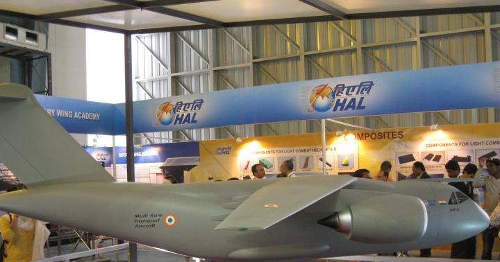
In total in Africa we can distinguish seven main mining regions.
Three of them are in North Africa and four in sub-Saharan Africa (Fig. 149).
Two of North Africa's mining regions predate World War II and have undergone further development in recent decades.
This is the region of the Atlas Mountains, where quite large deposits of iron, manganese, and polymetallic ores are associated with the mineralization processes that occurred during the Hercynian folding period.
But the main wealth of this area is the world's largest phosphorite-bearing belt, stretching along the southern slopes of the Atlas through the territory of Morocco, Algeria and Tunisia. The thickness of the phosphorite suite here reaches 80-100 m, and the total reserves of phosphorites (in terms of P205) amount to 22 billion tons, of which 21 billion are in Morocco. In terms of phosphorite production, this country is second only to the USA and China, and in terms of their exports it ranks first in the world.
The second mining region of North Africa is located in Egypt. Here, deposits of oil and natural gas, iron, titanium and other ores, phosphorites, rock salt and other fossil raw materials are associated with the sedimentary cover of the Nubian-Arabian massif and the rift basins of the Red Sea .

Rice. 149.
Mining areas in Africa
But, of course, the main mining region of North Africa is the youngest of them, located within the Algerian and Libyan parts of the Sahara Desert.
The territorial combination of mineral resources in it is much more limited and is represented in fact only by oil and natural gas, but in terms of the size of their reserves, production and the general role of the region in the world economy, it is far ahead.
Go to page: 1 234
Publications on geography
Small hydroelectric power station in Belarus
At the present stage of development of Belarus, the issue of replacing foreign energy resources and searching for alternative sources of electricity is becoming increasingly important, one of the promising sources of relatively ...
Economic and geographical characteristics of Povolzhsky economic region
This abstract is devoted to the economic and geographical characteristics of the Volga economic region." The problem of this study is relevant in modern conditions.
Povolzhsky district...
Physiographic characteristics of South Africa.
⇐ PreviousPage 8 of 8
High Africa. South Africa occupies the high part of the continent south of the watershed plateaus between the Congo and Zambezi river basins. The relief is dominated by plateaus and plateaus. The country is distinguished by a wide variety of landscapes due to sharp contrasts in humidity and topography of individual areas.
The main part is occupied by the South African Plateau, which is adjacent to the Cape Mountains to the south. The island of Madagascar forms a special natural area.
South African plateau lies within the Precambrian African Platform, occupying the Kalahari and Karoo syneclises. The Precambrian basement in the Kalahari syneclise lies shallow and in some places comes to the surface, forming protrusions and uplifts; The sedimentary cover is represented by horizontally lying continental deposits of the Upper Cretaceous and Cenozoic, mainly sandstones and sands (Kalahari formation).
The Karoo syneclise is a platform foredeep that arose in connection with the formation of the Cape mountain system; within its boundaries, the crystalline basement is deeply depressed and hidden under a thick layer of lagoonal sediments of Permian-Triassic age, mainly sandstones and shales (Karru formation); In some places these rocks are intruded by lavas.
Deposits of the Karoo Formation make up the southern and southeastern plateaus.
In terms of surface structure, the South African Plateau has much in common with the Congo Basin, but is located much higher. The central part of the plateau is occupied by plains Kalahari basins, lying at an altitude of 900-1000 m; Here on the surface there are red and white sands, hilly into low dunes.
The Kalahari Basin is surrounded on all sides by marginal plateaus and hills with numerous island outliers and mountains.
They gradually rise towards the outskirts to 1200-2500 m or more. The greatest width of the plateau is reached in the east and south of the region.
To the east are the Matabele and Weld plateaus, and to the south the Upper Karoo plateau.
Matabele Plateau lies between the Zambezi and Limpopo rivers. The plateau is composed of crystalline rocks; its surface is slightly hilly, there are separate island mountains. The marginal parts of the plateau are strongly dissected by river erosion and stand out sharply above the neighboring plains.
South of the Limpopo River is located Veld plateau. It consists of a series of stepped plateaus (High, Middle, Shrub and Low Veldt) descending towards the Kalahari Basin and the Limpopo River valley.
The plateau is composed of sandstones, shales and conglomerates of the Karoo formation, in some places intrusive and volcanic rocks.
Upper Karoo, located south of the Orange River, it closes the Kalahari Basin in the south, descending to it in several steps.
The plateau is composed of horizontally lying sandstones and shales, penetrated by numerous intrusions, forming remnant hills, sometimes sharp peaks.
In the west of the plateau, the strip of marginal plateaus narrows. The plateaus are composed of crystalline rocks and continental sediments. They are crowned by island mountains and remnant massifs, reaching their greatest heights in the Comas Plateau, where dislocated shales and quartzites are exposed.
The marginal plateaus of the South African plateau in the west, east and south drop steeply to the coastal plains and depression Great Karoo by the Great Escarpment, the outer slopes of which are deeply dissected by river erosion.
The Ledge reaches its greatest height in the east, in the Drakensberg Mountains. The southern part of the mountains - the Basuto Highlands, which has basaltic lavas - is the highest massif of the Kalahari ring frame. Its peak, Thabana Ntlenyana (3482 m), is the highest in South Africa.
Adjacent to the marginal plateaus in the east is a vast Mozambican lowland.
It is composed of Cretaceous and Tertiary deposits and is broken up by tectonic fractures in the northern part. In the west of the plateau, the marginal plateaus break off to the coastal plain. Its section between the Kunene and Orange rivers is the Namib Desert. The desert stretches from north to south for more than 1,500 km, occupying a narrow strip of ancient crystalline peneplain, fragmented by faults.
The plateau lies in the subequatorial, tropical and subtropical climate zones.
However, tropical climate types predominate. In the summer of the Southern Hemisphere, a local pressure depression forms over the Kalahari.
The north of the region (up to the middle reaches of the Zambezi) is irrigated by the summer equatorial monsoon. The entire eastern part is influenced by the southeast trade wind, bringing humid tropical air from the Indian Ocean, heated over the warm Mozambique Current.
Heavy rainfall occurs on the Mozambican lowlands, the slopes of the Great Escarpment and the eastern marginal plateaus. To the west of the Great Escarpment and the marginal plateaus, marine tropical air quickly transforms into continental air and the amount of precipitation decreases.
The West Coast is under the influence of the South Atlantic Anticyclone, strengthened by the powerful cold Benguela Current. Atlantic air warms up over the surface of the continent and produces almost no precipitation.
On the western marginal plateaus there is a front between maritime Atlantic and continental tropical air; here the amount of precipitation increases slightly.
In the winter of the Southern Hemisphere, a local anticyclone forms over the plateau, connecting with the South Atlantic and South Indian baric maxima. Downward air currents cause the dry season; there is no precipitation.
The South African plateau is an area of relatively high temperatures, with significant daily and annual fluctuations. But on the plateau, temperatures are moderated by significant altitude. Over most of the plateau, summer temperatures are + 20-* + 25°C, not rising above +40°C; winter temperatures are +10 - + 16°C.
The Upper Karoo Plateau experiences frosts in winter, while the Basotho Highlands experience snowfall.
The plateau is an area of predominantly scanty precipitation, distributed very unevenly across its territory. Their number decreases when moving from the east and north to the west and south. In the north of the region, up to 1500 mm of moisture falls per year; here the rainy season, brought by the equatorial monsoons, lasts up to 7 months. A lot of precipitation falls on the east coast, where the barrier role of the Great Escarpment is especially pronounced.
Precipitation is brought here by the southeastern summer trade wind (more than 1000 mm per year, and on the slopes of the Basuto Highlands - over 2000 mm). The most frequent and heaviest rainfall occurs from November to April. On the eastern marginal plateaus, rainfall decreases on the Veld plateau (750-500) and Matabele (750-1000 mm). The summer maximum precipitation remains in the interior regions, but the annual amounts decrease.
On the central Kalahari plains, the rainy season is reduced to 5-6 months, and the annual precipitation does not exceed 500 mm. To the southwest, precipitation decreases to 125 mm per year. The driest part of the area is the coastal Namib Desert (less than 100 mm of precipitation per year). Little precipitation will fall on the western marginal plateaus (up to 300 mm per year).
The river network on the plateau is poorly developed.
Most of the channels of the Kalahari, western and southern marginal plateaus do not have permanent watercourses. The largest river is the Zambezi.
The region's large rivers, the Orange and Limpopo, collect their waters from the Matabele Plateau and High Veldt. The Okovango River is the main internal drainage system of the Kalahari Basin. During the rainy season, the Okovango Basin sometimes overflows with water, the excess flowing from Okovango to the Zambezi and the Makarikari Salt Flat.
The large size of the South African plateau, differences in relief and climate create a variety of landscapes.
South Africa has almost all the continent's landscapes.
Along with zonal differences, sectoral differences also appear.
The region has well-defined eastern humid oceanic, mid-continental and western relatively cool desert oceanic sectors. In the eastern sector, where there is a lot of precipitation, zones of seasonally wet forests alternate from north to south: subequatorial (up to 20° S), tropical (20-30° S) and subtropical monsoon.
On the slopes of the Drakensberg Mountains, the altitudinal zone of the forest-meadow type is well defined. Seasonally wet forests occupy the windward slopes up to an altitude of 800-1000 m. Above that, shrubs and mountain-valley, predominantly coniferous forests, meadows, and rocky areas appear; similar vegetation is characteristic of the Basuto Highlands (bush thickets, isolated trees, meadows and rocky areas).
In the middle continental sector (Kalahari Basin and marginal plateaus) natural zones of savannas, woodlands and shrubs of the subequatorial and tropical zones, tropical and subtropical semi-deserts, and subtropical mountain steppes are developed.
However, semi-desert landscapes dominate.
Lowlands, plains, plateaus
Rare vegetation consists of xerophytic grasses, shrubs and individual acacias, euphorbias, and aloe. The Kalahari are characterized by wild watermelons, the stems of which cover large areas.
In the western oceanic sector is the tropical desert Nami b. In its southern part, along the valleys of dry riverbeds and in places of shallow groundwater, quite dense vegetation of succulent shrubs and subshrubs, low-growing acacias and tough grasses is developed.
The most interesting plant in the northern part of the desert is the ancient relict of Welwitschia.
The South African plateau, with its wide variety of landscapes, has a rich and varied fauna.
But the number of wild animals has now significantly decreased, and many of their species are disappearing. The number of herbivorous animals - antelopes, zebras, giraffes - has especially decreased; predators have also been severely exterminated. Lions, leopards, and wild cats have almost completely disappeared; hyenas and jackals are more common. The largest reserve in the region is national park Kruger in South Africa. Almost all African animals are collected here.
Cape Mountains located in the extreme southwest and south of the mainland, between the mouth of the Olifants River in the west and the city of Port Elizabeth in the east.
They stretch along the coast for 800 km, their average height is 1500 m. They are separated from the Great Escarpment of the South African Plateau by the Great Karoo depression.
Folding processes here occurred from the second half of the Carboniferous to the second half of the Triassic, to which their main phases belong.
Therefore, the Cape Mountains are somewhat younger in age than typical Hercynian structures. They were subsequently destroyed and smoothed, and then rejuvenated by later uplifts.
The Cape Mountains consist of several anticlinal ridges that are blocky in nature. The ridges are separated by wide longitudinal synclinal valleys and narrow transverse gorges.
The main part of the Cape Mountains is the southern system of latitudinal ranges.
Here are the highest (up to 2324 m) and longest mountains of Zwartberg (Small and Large) and Langeberg, between which lies the intermountain Little Karoo plateau. To the east, the ridges decline and end in rocky headlands into the sea. In the extreme south they break up into small isolated ridges and massifs rising among the coastal plain. Another system of ridges extends along the Atlantic Ocean in a north-northwest direction.
In the southwest and south, the mountains approach the coast at an angle, indented by convenient bays.
The climate of the Cape Mountains is subtropical. In the southwest it is of the Mediterranean type, with rainy, warm winters and dry, hot summers. Temperatures are moderated by altitude and sea. In Cape Town, the average temperature in January is + 21 ° C, in July + 12 ° C. The rains begin in April, are heavy from June to September, and then stop as humid westerly winds give way to winds from subtropical anticyclones.
In winter, snow falls on the mountain tops. In the western part of the mountains, on their windward slopes, the greatest amount of precipitation falls (up to 1800 mm per year). To the east their number decreases to 800 mm. East of 22°E. In the precipitation regime, the typical features of the Mediterranean climate disappear, and the summer maximum begins to predominate due to the penetration of humid oceanic monsoons onto the mainland.
On the coastal plain there is little precipitation (in Cape Town - 650 mm per year). The climate of the inner parts of the mountains is subtropical continental.
The Cape Mountains are covered mainly by Mediterranean type vegetation with a predominance of evergreen hard-leaved shrubs and herbaceous perennials.
The landscapes here have much in common with the Atlas Mountains. They are also characterized by brown (typical and leached) and mountain-forest brown soils.
However, the floristic composition of the vegetation is different, specific to the Cape flora. Very characteristic times
personal heathers, proteas, pelargoniums, mesembryanthemums, aloe, cactus-like euphorbias, fatworts, etc. Interesting are the Cape nightshade with yellow poisonous fruits, the silver tree with silvery fluffy leaves, the Cape water lily with red flowers, wild watermelon, etc.
There are few trees among the Cape flora. The predominant species are evergreen shrubs and perennial grasses.
Thickets of evergreen hard-leaved shrubs form the fynbos formation (an analogue of the Mediterranean maquis), which arose on the site of cleared forests that previously covered the mountain slopes.
Fynbos includes members of the Proteaceae (including silverwood), Ericaceae, Legumes, Campanaceae and Rutaceae families.
Forests have survived only on inaccessible, well-watered mountain slopes.
In the west, in deep and inaccessible valleys, you can find a few groves of southern conifers (podocarpus, etc.), in the east, on the slopes of the mountains, there are dense monsoon mixed forests, consisting of coniferous and evergreen deciduous trees (laurel olive, cape beech, etc. .) trees. Palm groves grow in the coastal lowlands.
Vast areas in the Cape Mountains are covered with grasses with a predominance of bulbous, tuberous and rhizomatous forms from the family Amaryllis, Iris, Orchids and Lamiaceae.
Characteristic are immortelle, cineraria and other Compositae. On especially dry and hot leeward slopes and in depressions, semi-desert landscapes with succulent shrubs and subshrubs are developed. In the Little Karoo depression, thickets of acacias and aloe are common along the rivers; in other parts the vegetation is represented by rare shrubs
⇐ Previous12345678
Africa is a part of the world with an area of 30.3 million km 2 with islands, this is the second place after Eurasia, 6% of the entire surface of our planet and 20% of the land.
Geographical position
Africa is located in the Northern and Eastern Hemispheres (most of it), a small part in the Southern and Western. Like all large fragments of the ancient continent, Gondwana has a massive outline, with no large peninsulas or deep bays. The length of the continent from north to south is 8 thousand km, from west to east - 7.5 thousand km. In the north it is washed by the waters of the Mediterranean Sea, in the northeast by the Red Sea, in the southeast by the Indian Ocean, in the west by the Atlantic Ocean. Africa is separated from Asia by the Suez Canal, and from Europe by the Strait of Gibraltar.

Main geographical characteristics
Africa lies on an ancient platform, which causes its flat surface, which in some places is dissected by deep river valleys. On the coast of the mainland there are small lowlands, the northwest is the location of the Atlas Mountains, the northern part, almost entirely occupied by the Sahara Desert, is the Ahaggar and Tibetsi highlands, the east is the Ethiopian Highlands, the southeast is the East African Plateau, the extreme south is the Cape and Drakensberg mountains The highest point in Africa is the Kilimanjaro volcano (5895 m, Masai plateau), the lowest is 157 meters below ocean level in Lake Assal. Along the Red Sea, in the Ethiopian Highlands and to the mouth of the Zambezi River, the largest fault in the world stretches earth's crust, which is characterized by frequent seismic activity.

The following rivers flow through Africa: Congo (Central Africa), Niger (West Africa), Limpopo, Orange, Zambezi (South Africa), as well as one of the deepest and longest rivers in the world - the Nile (6852 km), flowing from the south to north (its sources are on the East African Plateau, and it flows, forming a delta, into the Mediterranean Sea). Rivers are characterized by high water content exclusively in the equatorial belt, due to the large amount of precipitation there; most of them are characterized by high flow rates and have many rapids and waterfalls. In lithospheric faults filled with water, lakes were formed - Nyasa, Tanganyika, the largest freshwater lake in Africa and the second largest lake in area after Lake Superior (North America) - Victoria (its area is 68.8 thousand km 2, length 337 km, maximum depth - 83 m), the largest salty endorheic lake is Chad (its area is 1.35 thousand km 2, located on the southern edge of the world's largest desert, the Sahara).

Due to Africa's location between two tropical zones, it is characterized by high total solar radiation, which gives the right to call Africa the hottest continent on Earth (the highest temperature on our planet was recorded in 1922 in Al-Aziziya (Libya) - +58 C 0 in the shadow).

On the territory of Africa, such natural zones are distinguished as evergreen equatorial forests (the coast of the Gulf of Guinea, the Congo basin), in the north and south turning into mixed deciduous-evergreen forests, then there is a natural zone of savannas and woodlands, extending to Sudan, East and South Africa, to In northern and southern Africa, savannas give way to semi-deserts and deserts (Sahara, Kalahari, Namib). In the southeastern part of Africa there is a small zone of mixed coniferous-deciduous forests, on the slopes of the Atlas Mountains there is a zone of hard-leaved evergreen forests and shrubs. Natural areas mountains and plateaus are subject to the laws of altitudinal zonation.
African countries

The territory of Africa is divided between 62 countries, 54 are independent, sovereign states, 10 dependent territories, belonging to Spain, Portugal, Great Britain and France, the rest are unrecognized, self-proclaimed states - Galmudug, Puntland, Somaliland, Sahrawi Arab Democratic Republic (SADR). For a long time, Asian countries were foreign colonies of various European states and only gained independence by the middle of the last century. Depending on the geographical location Africa is divided into five regions: Northern, Central, Western, Eastern and Southern Africa.
List of African countries
Nature
 Mountains and plains of Africa
Most of the African continent is plain. Available mountain systems, highlands and plateaus. They are presented:
- the Atlas Mountains in the northwestern part of the continent;
- the Tibesti and Ahaggar highlands in the Sahara Desert;
- Ethiopian Highlands in the eastern part of the mainland;
- Drakensberg Mountains in the south.
The most high point country is the Kilimanjaro volcano, 5,895 m high, belonging to the East African Plateau in the southeastern part of the continent...
 Deserts and savannas
The largest desert zone of the African continent is located in the northern part. This is the Sahara Desert. On the southwest side of the continent is another smaller desert, the Namib, and from there into the continent to the east there is the Kalahari Desert.
The savannah territory occupies the bulk of Central Africa. In area it is much larger than the northern and southern parts of the mainland. The territory is characterized by the presence of pastures typical of savannas, low shrubs and trees. The height of herbaceous vegetation varies depending on the amount of precipitation. These can be practically desert savannas or tall grasses, with a grass cover from 1 to 5 m in height...
 Rivers
The longest river in the world, the Nile, is located on the African continent. The direction of its flow is from south to north.
The list of major water systems of the mainland includes the Limpopo, Zambezi and Orange River, as well as the Congo, which flows through Central Africa.
Located on the Zambezi River famous waterfall Victoria, 120 m high and 1,800 meters wide...
 Lakes
Lakes
The list of large lakes on the African continent includes Lake Victoria, which is the second largest freshwater body of water in the world. Its depth reaches 80 m, and its area is 68,000 square km. Two more large lakes continent: Tanganyika and Nyasa. They are located in faults of lithospheric plates.
There is Lake Chad in Africa, which is one of the world's largest endorheic relict lakes that have no connection with the world's oceans...
 Seas and oceans
The African continent is washed by the waters of two oceans: the Indian and the Atlantic. Also off its shores are the Red and Mediterranean Seas. From the Atlantic Ocean in the southwestern part, the waters form the deep Gulf of Guinea.
Despite the location of the African continent, the coastal waters are cool. This is influenced by the cold currents of the Atlantic Ocean: the Canary in the north and the Bengal in the southwest. From the Indian Ocean, the currents are warm. The largest are Mozambique, in northern waters, and Agulhas, in southern...
 Forests of Africa
Forests make up a little more than a quarter of the entire territory of the African continent. Here are subtropical forests growing on the slopes of the Atlas Mountains and the valleys of the ridge. Here you can find holm oak, pistachio, strawberry tree, etc. Coniferous plants grow high in the mountains, represented by Aleppo pine, Atlas cedar, juniper and other types of trees.
Closer to the coast there are cork oak forests; in the tropical region, evergreen equatorial plants are common, for example, mahogany, sandalwood, ebony, etc...
 Nature, plants and animals of Africa
The vegetation of the equatorial forests is diverse, with about 1000 species of various types of trees growing here: ficus, ceiba, wine tree, oil palm, wine palm, banana palm, tree ferns, sandalwood, mahogany, rubber trees, Liberian coffee tree, etc. . Many species of animals, rodents, birds and insects live here, living directly on the trees. On the ground live: brush-eared pigs, leopards, African deer - a relative of the okapi giraffe, large apes - gorillas...
40% of Africa's territory is occupied by savannas, which are huge steppe areas covered with forbs, low, thorny bushes, milkweed, and isolated trees (tree-like acacias, baobabs).

Here there is the largest concentration of such large animals as: rhinoceros, giraffe, elephant, hippopotamus, zebra, buffalo, hyena, lion, leopard, cheetah, jackal, crocodile, hyena dog. The most numerous animals of the savannah are herbivores such as: hartebeest (antelope family), giraffe, impala or black-footed antelope, various types of gazelles (Thomson's, Grant's), blue wildebeest, and in some places rare jumping antelopes - springboks - are also found.

The vegetation of deserts and semi-deserts is characterized by poverty and unpretentiousness; these are small thorny bushes and separately growing tufts of herbs. The oases are home to the unique Erg Chebbi date palm, as well as plants that are resistant to drought conditions and salt formation. In the Namib Desert, unique plants such as Welwitschia and Nara grow, the fruits of which are eaten by porcupines, elephants and other desert animals.

Animals here include various species of antelopes and gazelles, adapted to the hot climate and capable of traveling vast distances in search of food, many species of rodents, snakes, and turtles. Lizards. Among the mammals: spotted hyena, common jackal, maned sheep, Cape hare, Ethiopian hedgehog, Dorcas gazelle, sabre-horned antelope, Anubis baboon, wild Nubian ass, cheetah, jackal, fox, mouflon, there are resident and migratory birds.
Climatic conditions
 Seasons, weather and climate of African countries
The central part of Africa, through which the equator line passes, is in an area of low pressure and receives sufficient moisture; the territories north and south of the equator are in the subequatorial climate zone, this is a zone of seasonal (monsoon) moisture and an arid desert climate. Far North and the south are in the subtropical climate zone, the south receives precipitation brought by air masses from the Indian Ocean, the Kalahari Desert is located here, the north has minimal precipitation due to the formation of a high pressure area and the characteristics of the movement of trade winds, the largest desert in the world is the Sahara, where the amount of precipitation is minimal , in some areas it does not fall out at all...
Resources
 Natural Resources of Africa
In terms of water resources, Africa is considered one of the poorest continents in the world. The average annual volume of water is only sufficient to satisfy primary needs, but this does not apply to all regions.
Land resources are represented by large areas with fertile lands. Only 20% of all possible lands are cultivated. The reason for this is the lack of adequate water volume, soil erosion, etc.
African forests are a source of timber, including valuable species. The countries in which they grow, export raw materials. Resources are being used unwisely and ecosystems are being destroyed little by little.
In the depths of Africa there are deposits of minerals. Among those sent for export: gold, diamonds, uranium, phosphorus, manganese ores. There are significant reserves of oil and natural gas.
Energy-intensive resources are widely available on the continent, but they are not used due to the lack of proper investment...

Among the developed industrial sectors of the countries of the African continent, the following can be noted:
- the mining industry, which exports minerals and fuels;
- the oil refining industry, distributed mainly in South Africa and North Africa;
- chemical industry specializing in the production of mineral fertilizers;
- as well as the metallurgical and engineering industries.
The main agricultural products are cocoa beans, coffee, corn, rice and wheat. Oil palm is grown in tropical regions of Africa.
Fishing is poorly developed and accounts for only 1-2% of the total agricultural output. Livestock production indicators are also not high and the reason for this is the infection of livestock by tsetse flies...
Culture
 Peoples of Africa: culture and traditions
There are approximately 8,000 peoples and ethnic groups living in 62 African countries, totaling approximately 1.1 billion people. Africa is considered the cradle and ancestral home of human civilization; it was here that the remains of ancient primates (hominids) were found, which, according to scientists, are considered the ancestors of people.
Most peoples in Africa can number several thousand people or several hundred living in one or two villages. 90% of the population are representatives of 120 nations, their number is more than 1 million people, 2/3 of them are peoples with a population of more than 5 million people, 1/3 are peoples with a population of more than 10 million people (this is 50% of the total population of Africa) - Arabs , Hausa, Fulbe, Yoruba, Igbo, Amhara, Oromo, Rwanda, Malagasy, Zulu...
There are two historical and ethnographic provinces: North African (the predominance of the Indo-European race) and Tropical African (the majority of the population is the Negroid race), it is divided into such areas as:
- West Africa. Peoples speaking the Mande languages (Susu, Maninka, Mende, Vai), Chadian (Hausa), Nilo-Saharan (Songai, Kanuri, Tubu, Zaghawa, Mawa, etc.), Niger-Congo languages (Yoruba, Igbo, Bini, Nupe, Gbari, Igala and Idoma, Ibibio, Efik, Kambari, Birom and Jukun, etc.);
- Equatorial Africa. Inhabited by Buanto-speaking peoples: Duala, Fang, Bubi (Fernandans), Mpongwe, Teke, Mboshi, Ngala, Como, Mongo, Tetela, Cuba, Kongo, Ambundu, Ovimbundu, Chokwe, Luena, Tonga, Pygmies, etc.;
- South Africa. Rebellious peoples and speakers of Khoisani languages: Bushmen and Hottentots;
- East Africa. Bantu, Nilotes and Sudanese people groups;
- Northeast Africa. Peoples speaking Ethio-Semitic (Amhara, Tigre, Tigra), Cushitic (Oromo, Somali, Sidamo, Agaw, Afar, Konso, etc.) and Omotian languages (Ometo, Gimirra, etc.);
- Madagascar. Malagasy and Creoles.
In the North African province, the main peoples are considered to be Arabs and Berbers, belonging to the southern European minor race, mainly professing Sunni Islam. There is also an ethno-religious group of Copts, who are direct descendants of the Ancient Egyptians, they are Monophysite Christians.
These are humid forests with a dense network of deep rivers. The eastern part stands out as sublime, the southern part as endless.
North Africa- the most extensive part of the continent. It is based on the plate of the African-Arabian ancient platform. The prevailing relief is plateaus and hills 300-400 m high. Between them rise the rocky highlands of Ahaggar, Tibesti, Darfur, Jos, formed on the crystalline shields of the ancient platform. In the northwest, the folded Atlas Mountains adjoin the platform.
Atlas Mountains- a mountainous country consisting of a system of mountain ranges, intermountain plateaus and depressions. Here, on the coastal plains and windward slopes of the mountains, there are dry, hot summers and mild, wet winters, while on the intermountain plateaus and internal slopes of the ridges it is arid and harsh due to the high altitude. The nature of Atlas has been greatly changed by man.
The world's largest tropical desert, its length is 6,000 km from west to east and 2,000 km from north to south. It owes its existence to a continental tropical climate with precipitation less than 50 mm per year and high temperatures.
Due to the different composition of rocks, different types of deserts are formed here: rocky-gravelly, pebble, sandy, clayey. Sandy deserts with dune topography occupy only about 20% of the Sahara.
There is almost no surface water in the Sahara. The only large one crossing receives food outside its borders.
Sudanese plains lie south of the Sahara. They are located in the subequatorial climate zone. The duration of the rainy season decreases from south to north from 10 to 2 months. There are many rivers in the western and eastern parts of the Sudanese plains. The largest of them are the White Nile. The central part of the plains is an area of lake, which changes its size and shape depending on precipitation.
The natural conditions of the Sudanese plains are the most favorable for human life. The population has long been engaged in cattle breeding here.
Central Africa covers the Gulf of Guinea coast and basin. The equatorial climate prevails here and there is a dense network of deep rivers.
The northern coast of the Gulf of Guinea is formed by hills and plateaus, descending in steps to the coastal lowlands. In the east of the region is located active volcano(4100 m). On its slopes facing the bay, a record amount of precipitation falls for Africa - 9000 mm per year. The largest river, the Niger, forms a large delta when it flows into the Gulf of Guinea. Nature has been greatly altered by humans, since the area has a long history of development and high population density.

The central part of the Congo Basin is occupied by humid equatorial forests. They consist of hundreds of species of trees, vines, shrubs and grasses. The fauna is also diverse: okapi dwarf giraffes, water deer, elephants, hippos, various monkeys, birds. Along the coast of the Gulf of Guinea, forest areas have been greatly reduced due to logging and burning, giving way to open forests and savannas or plantations of tropical crops.
South Africa located south of the watershed of the Congo and Zambezi rivers. divided into three natural area.
The South African Plateau is a system of plateaus formed by the outcroppings of the platform's basement. The plateau rises towards the outskirts of the continent, and in the internal parts there are depressions. Among them, the largest is. In the southeast, the Drakensberg Mountains adjoin the plateau. The plateau is located in, but the temperatures here, due to the significant altitude, are not as high as in North Africa. Natural zones, in accordance with the decrease in precipitation, change from east to west. In the east, tall grass savannas are common. These are beautiful pastures and fertile plains. Acacias, aloe, euphorbia, and herbs with powerful rhizomes grow here, blooming brightly during the rainy season. To the west, desert savannas predominate, occupying most of the Kalahari. In the Kalahari there are barren rocky areas. On the coast washed by cold currents is the Namib Desert.
There are few rivers with permanent water flow, only navigable. The majestic one is located on it. The South African plateau has a rich fauna. In many areas, hunting is the main occupation of the population.
Cape Mountains- These are low and medium-height ridges, approaching the coast indented with convenient bays in the southwest of the mainland. Subtropical and shrubland with a large number of endemic species grew here in the past. From here, a variety of ornamental plants spread throughout the world. However, almost no natural vegetation has been preserved.
Madagascar- an island region, the relief and climate of which have much in common with the relief and climate of neighboring areas of the mainland. The organic world is characterized by great originality due to its long development in isolation. Among wild animals there are almost no ungulates and predators, poisonous snakes,
East Africa- the highest part of the continent, called the “roof of Africa”. There are two natural areas here -
East Africa is a densely populated area, and land has been used for agriculture for a long time. In the Ethiopian Highlands, the belt of mountain savannas up to an altitude of 2.5 km is most favorable for human life. This belt is considered the birthplace of the coffee tree, durum wheat, rye, barley and some other cultivated plants.
Nowhere in the world is there such a diversity of large animals as in East Africa. However, prolonged extermination caused a decrease in their number, so in many countries they created National parks. Kagera, Mnunt-Kenya, Serengeti, and Kivu are world famous. The exotic nature and the possibility of sport hunting attract a large number of foreign tourists to the parks, which brings income to the countries of the area.