Despite the fact that there are many different beautiful rivers in Russia, nevertheless, the Volga is the most valuable for it, the population of the country calls it majestic, based on the fact that the Volga is like the queen of all Russian rivers. Scientists geologists determine from sediments in the earth's crust that over the immeasurably long history of the Earth, significant areas of the present Volga region have more than once turned into the seabed. One of the seas slowly retreated to the south about twenty million years ago, and then the Volga River flowed in its wake. The Volga began not in Valdai, but near Ural mountains. It seemed to cut a corner, taking the direction towards Zhiguli from there, and then carried the waters much further to the east than now. Movements earth's crust, the formation of new hills and depressions, sharp fluctuations in the level of the Caspian Sea and other reasons forced the Volga River to change direction.
Origin of the river's name
From the facts of ancient history it is known that the then famous Greek scientist named Ptolemy in his “Geography” called the Volga River by the name “Ra”. Despite the fact that he lived far from the Volga, on the coast of Africa, in the city of Alexandria, rumors about this great river reached there too. This was in the 2nd century AD. Later, in the Middle Ages, the Volga was known as Itil.
According to one version modern name The Volga acquired the ancient Mari name of the river Volgydo or, which translated meant “bright”. According to another version, the name of the Volga comes from the Finno-Ugric word Volkea, meaning “light” or “white”. There is also a version that the name Volga comes from the name Bulga, associated with the Volga Bulgarians who lived on its banks. But the Bulgarians themselves (the ancestors of modern Tatars) called the reuk “Itil”, a word that means “river” (there is, however, another version that the meanings of the hydronyms Volga and Itil then did not coincide with modern ones), it is believed that the most likely origin of the ethnonym “Volga” "from the Proto-Slavic word meaning volgly - vologa - moisture, thus the possible meaning of the name Volga is as “water” or “moisture”, so to speak, “big water” is also suitable, due to the enormous size of the river. The Slavic version of the origin of the name is evidenced by the presence of the Vlga rivers in the Czech Republic and Vilga in Poland.

Source of the Volga
The source of the Volga is a spring near the village of Volgoverkhovye in the Tver region. In the upper reaches, within the Valdai Upland, the Volga passes through small lakes - Maloe and Bolshoye Verkhity, then through a system of large lakes known as the Upper Volga lakes: Sterzh, Vselug, Peno and Volgo, united into the Upper Volga Reservoir.
Geographical location of the river
The Volga originates on the Valdai Hills (at an altitude of 229 m) and flows into the Caspian Sea. The length of the Volga is 3530 kilometers. The mouth lies 28 m below sea level. The total fall is 256 m. The Volga is the world's largest river of internal flow, that is, not flowing into the world ocean. The source of the Volga is a spring near the village of Volgoverkhovye in the Tver region. In the upper reaches, within the Valdai Upland, the Volga passes through small lakes - Maloe and Bolshoye Verkhity, then through a system of large lakes known as the Upper Volga lakes: Sterzh, Vselug, Peno and Volgo, united into the so-called Upper Volga reservoir.


The river can be divided into three main parts:
Upper Volga, the largest tributaries of the Upper Volga are Selizharovka, Tma, Tvertsa, Mologa, Sheksna and Unzha. After the Volga passed through the system of Verkhnevolzhsky lakes in 1843, a dam (Verkhnevolzhsky Beishlot) was built to regulate water flow and maintain navigable depths during low water periods. Between the cities of Tver and Rybinsk on the Volga, the Ivankovo Reservoir (the so-called Moscow Sea) with a dam and a hydroelectric power station near the city of Dubna, the Uglich Reservoir (HPP near Uglich), and the Rybinsk Reservoir (HPP near Rybinsk) were created. In the Rybinsk-Yaroslavl region and below Kostroma, the river flows in a narrow valley among high banks, crossing the Uglich-Danilovskaya and Galich-Chukhloma uplands. Further, the Volga flows along the Unzhenskaya and Balakhninskaya lowlands. Near Gorodets (above Nizhny Novgorod), the Volga, blocked by the dam of the Gorky hydroelectric station, forms the Gorky reservoir.

The middle Volga, in the middle reaches, below the confluence of the Oka, the Volga becomes even more full-flowing. It flows along the northern edge of the Volga Upland. The right bank of the river is high, the left is low. The Cheboksary Hydroelectric Power Station was built near Cheboksary, above the dam of which the Cheboksary Reservoir is located. The largest tributaries of the Volga in its middle reaches are the Oka, Sura, Vetluga and Sviyaga.


The Lower Volga, where in the lower reaches, after the confluence of the Kama, the Volga becomes a mighty river. It flows here along the Volga Upland. Near Togliatti, above the Samara Luka, which is formed by the Volga, skirting the Zhigulevsky Mountains, the Zhigulevskaya Hydroelectric Power Station dam was built; Above the dam lies the Kuibyshev Reservoir. On the Volga near the city of Balakovo, the Saratov hydroelectric power station dam was erected. The Lower Volga receives relatively small tributaries - Sok, Samara, Bolshoi Irgiz, Eruslan. 21 km above Volgograd, the left branch, Akhtuba (length 537 km), separates from the Volga, which flows parallel to the main channel. The vast space between the Volga and Akhtuba, crossed by numerous channels and old rivers, is called the Volga-Akhtuba floodplain; The width of the floods within this floodplain previously reached 20-30 km. The Volzhskaya Hydroelectric Power Station was built on the Volga between the beginning of Akhtuba and Volgograd; Above the dam lies the Volgograd Reservoir.
The Volga Delta begins at the point where Akhtuba separates from its channel (in the Volgograd area) and is one of the largest in Russia. There are up to 500 branches, channels and small rivers in the delta. The main branches are Bakhtemir, Kamyzyak, Old Volga, Bolda, Buzan, Akhtuba (of which Bakhtemir is maintained in navigable condition, forming the Volga-Caspian Canal).

Territorial division of the river
Geographically, the Volga basin includes Astrakhan, Volgograd, Saratov, Samara, Ulyanovsk, Nizhny Novgorod, Yaroslavl, Ivanovo, Kostroma, Moscow, Smolensk, Tver, Vladimir, Kaluga, Orel, Ryazan, Vologda, Kirov, Penza, Tambov regions, Perm Territory, Udmurtia, Mari El, Mordovia, Chuvashia, Tatarstan, Bashkortostan, Kalmykia, Komi, Moscow, and some others.
The Volga is connected to the Baltic Sea by the Volga-Baltic waterway, the Vyshnevolotsk and Tikhvin systems; with the White Sea - through the Severodvinsk system and through the White Sea-Baltic Canal; with the Azov and Black Seas - through the Volga-Don Canal.


The Volga River is mainly fed by external meltwater. Rains, which fall mainly in summer, and groundwater, from which the river lives in winter, play a lesser role in its nutrition. In accordance with this, the annual level of the river is distinguished by: high and prolonged spring floods, fairly stable summer low water and low winter low water. The duration of the flood is on average 72 days. The maximum water rise usually occurs in the first half of May, half a month after the spring ice drift. From the beginning of June to October - November, summer low water sets in. Thus, most of The navigation period, when the Volga River is ice-free (an average of 200 days), coincides with a period of low low-water levels (2 - 3 m).

History of the Volga River
It is believed that the first mention of the Volga is found in the works of the ancient Greek historian Herodotus (5th century BC). In the story about the campaign of the Persian king Darius against the Scythians, Herodotus reports that Darius, pursuing the Scythians across the Tanais (Don) River, stopped at the Oar River. They are trying to identify the Oar River with the Volga, although Herodotus also reported that the Oar flows into Maeotis (the Sea of Azov). Sometimes they also see the Volga in another river, which was mentioned in the 1st century. BC e. reported Diodorus Siculus.
At first the Scythians lived in very small numbers near the Araks River and were despised for their ignominy. But even in ancient times, under the control of one warlike king distinguished by his strategic abilities, they acquired a country in the mountains up to the Caucasus, and in the lowlands of the coast of the Ocean and Lake Meotia - and other areas up to the Tanais River.
In written ancient Roman sources of the 2nd-4th centuries, the Volga is geographically identified as the river Ra - generous, in Arabic sources of the 9th century it is called Atel - the river of rivers, the great river. In the earliest ancient Russian chronicle, “The Tale of Bygone Years,” it is said: “From that Volokovo forest the Volga will flow to the east and flow... into the Khvalisskoye Sea.” Volokovsky Forest is the ancient name of the Valdai Hills. Khvalissky was the name given to the Caspian Sea.
The geographical position of the Volga and its large tributaries determined its importance as a trade route between East and West by the 8th century. It was along the Volga route that the flow of Arab silver poured into the Scandinavian countries. Fabrics and metals were exported from the Arab Caliphate; slaves, furs, wax, and honey were exported from the Slavic lands. In the 9th-10th centuries, a significant role in trade was played by such centers as the Khazar Itil at the mouth, the Bulgar Bulgar in the Middle Volga, the Russian Rostov, Suzdal, Murom in the Upper Volga region. Since the 11th century, trade has weakened, and in the 13th century, the Mongol-Tatar invasion disrupted economic ties, except for the upper Volga basin, where Novgorod, Tver and the cities of Vladimir-Suzdal Rus' played an active role. Since the 15th century, the importance of the trade route has been restored, the role of such centers as Kazan, Nizhny Novgorod, Astrakhan. The conquest of the Kazan and Astrakhan khanates by Ivan the Terrible in the mid-16th century led to the unification of the entire Volga river system in Russian hands, which contributed to the flourishing of Volga trade in the 17th century. New ones are emerging big cities- Samara, Saratov, Tsaritsyn; Yaroslavl, Kostroma, and Nizhny Novgorod play a major role. Large caravans of ships (up to 500) sail along the Volga. In the 18th century, the main trade routes moved to the West, and the economic development of the lower Volga was hampered by weak population and raids by nomads. The Volga basin in the 17th-18th centuries was the main area of action for the rebel peasants and Cossacks during the peasant wars under the leadership of S.T. Razin and E.I. Pugacheva.

In the 19th century, there was a significant development of the Volga trade route after the Mariinsky river system connected the Volga and Neva basins (1808); a large river fleet(in 1820 - the first steamship), a huge army of barge haulers (up to 300 thousand people) works on the Volga. Large shipments of bread, salt, fish, and later oil and cotton are carried out.
The development of the Civil War of 1917-22 in Russia is largely connected with the establishment in 1918 of the power of the Committee of the Constituent Assembly in a number of cities of the Volga region. The restoration of Bolshevik control over the Volga is considered an important turning point in the Civil War, as control over the Volga provided access to grain resources and Baku oil. An important role in Civil War played a role in the defense of Tsaritsyn, in which I.V. Stalin played an active role, which was the reason for renaming Tsaritsyn to Stalingrad.
During the years of socialist construction, in connection with the industrialization of the entire country, the importance of the Volga Route increased. Since the late 30s of the 20th century, the Volga has also begun to be used as a source of hydropower. During the Great Patriotic War of 1941-45, the largest Battle of Stalingrad took place on the Volga, which preserved the name of the Volga in the history of the liberation of the region. In the post-war period, the economic role of the Volga increased significantly, especially after the creation of a number of large reservoirs and hydroelectric power stations.

Natural world of the Volga
In the Upper Volga basin there are large forest areas; in the Middle and partly in the Lower Volga region, large areas are occupied by grain and industrial crops. Melon growing and gardening are developed. The Volga-Ural region has rich oil and gas deposits. Near Solikamsk there are large deposits of potassium salts. In the Lower Volga region (Lake Baskunchak, Elton) - table salt.
In terms of fish diversity, the Volga is one of the richest rivers. The Volga River basin is home to 76 different species of fish and 47 subspecies of fish. The following fish enter the Volga from the Caspian Sea: lamprey, beluga, sturgeon, stellate sturgeon, thorn, white fish, anadromous Volga herring or common herring; semi-anadromous: carp, bream, pike perch, roach, etc. The following fish constantly live in the Volga: sterlet, carp, bream, pike perch, ide, pike, burbot, catfish, perch, ruff, asp. Beluga is the most legendary fish of the Caspian basin. Its age reaches 100 years, and its weight is 1.5 tons. At the beginning of the century, belugas weighing over a ton lived in the Volga; the weight of caviar in females was up to 15% of the total body weight. Red fish is the glory of the Astrakhan region. Five species of sturgeon fish live here - Russian sturgeon, stellate sturgeon, beluga, thorn and sterlet. The first four species are anadromous, and sterlet is a freshwater fish. Farms also breed a hybrid of beluga and sterlet - bester. Herring-like fish are represented by Caspian shad, common sprat and blackback and Volga herring.
Among the salmon-like fish, the whitefish is found, the only representative of the pike-like fish is the pike. The carp fish of the lower reaches of the Volga include bream, carp, roach, rudd, gold and silver crucian carp, asp, silver bream, gudgeon, grass carp, white and bighead carp.
Perch fish in the Volga are represented by river perch, ruffe, as well as pike perch and bersh. In the stagnant shallow freshwater reservoirs of the lower Volga, the only representative of the stickleback order, the southern stickleback, is found everywhere.

The influence of the Volga in creativity
In the figurative perception of the essence of the Russian people, the Volga plays an exceptional and central role; it is the root and core of the entire Russian people, a figurative ideal. It is always animated, human qualities are attributed to it, and the ideal Russian person must correspond to the image of this river. The Volga is not found very often in literature and art, but truly cult works are associated with its image. In the culture of the 19th and early 20th centuries, the most “folk” representatives of culture are associated with the Volga: N.A. Nekrasov, Maxim Gorky, F.I. Chaliapin. Soviet art made full use of the image of the Volga created by the democratic art of pre-revolutionary Russia. The Volga is identified with the Motherland; it is a symbol of freedom, space, breadth and greatness of the spirit of Soviet people. The central role in the construction of this image was played by the film “Volga-Volga” and the song “The Volga Flows” performed by Lyudmila Zykina.
Volga Delta
The Volga Delta is the place where the first biosphere reserve in Russia was created in 1919. Five years ago, another federal state nature reserve appeared in the Astrakhan region - Bogdinsko-Baskunchaksky. We understand that nature reserves constantly face many problems, the solution of which cannot be postponed, therefore the financing of their activities is largely the responsibility of the regional budget. Astrakhan residents are proud that last year Maly Zhemchuzhny Island received the status of a federal natural monument. This is one of the most valuable natural reserves of the Northern Caspian Sea. In addition, 800 thousand hectares of the delta have the status of a wetland of international importance. In our region there are four state natural reserves of regional significance.

The Volga Delta is recognized as the most environmentally friendly delta in Europe. Our task, despite the fact that the territory for economic use here is highly valued, is to expand the boundaries nature reserves. Now, for example, the idea of creating so-called biosphere testing grounds in the region is being explored. We are one of the first to do this in Russia. 300 thousand hectares of the Northern Caspian Sea and the Volga delta are to be reserved for them. In these spaces, mostly water, modern methods of economic activity will be tested that will not harm the unique environment. We are for openness of environmental information and always promptly respond to any signals about emergencies and problems.


The largest river valley in Europe, the Volga-Akhtuba floodplain and the Volga River delta, as well as the surrounding desert, have always attracted the attention of botanists. The first studies mainly concerned the species composition of the flora. At different times, the region was visited by: P. S. Pallas, K. K. Klaus, E. A. Eversmann, I. K. Pachosky, A. Ya Gordyagin and many other outstanding travelers and botanists. At the end of the 20s of this century, more attention began to be paid to floodplain habitats. To one of the first researchers of the vegetation cover of the Lower Volga valley - S. I. Korzhinsky (in 1888) - the floristic composition of its meadows and swamps initially seemed rather monotonous, but later these ideas began to change.A. G. Ramensky (in 1931) noted a change in the composition of herbaceous communities of the Volga-Akhtuba floodplain and delta as they moved downstream of the river.
Story
Until the 30s. In the twentieth century, the Volga was practically used only as a transport route and a fishing basin. The main organic disadvantages of the Volga trade route for many centuries were the lack of water connections with the World Ocean and the stepwise nature of the depths. They once tried to overcome the first disadvantage by organizing portages. But only very small vessels could be transported across watersheds. Peter I organized work to connect the Volga with the Don and the Baltic Sea. However, due to the lack of equipment corresponding to the scale of the work, the efforts expended to connect the Volga with the Don were not crowned with success. The fate of the work on the Upper Volga was different. In 1703 they began and in 1709 completed the construction of the Vyshnevolotsk system. Through the rivers Tvertsa, Tsna, Meta, Volkhov, Ladoga lake and Niva, cargo transported along the Volga gained access to the Baltic Sea. The limited capacity of this water system forced us to look for other ways to develop water connections between the Volga basin and the Baltic.

In 1810, the Mariinsk water system came into operation, connecting the Volga with the Baltic through the rivers Sheksna, Vyterga, Lake Onega, and the river. Svir, Lake Ladoga and Neva, and in 1811 - the Tikhvin water system, which did the same through the rivers Mologa, Chagodoma, Syas and the Ladoga Canal.
In 1828, the construction of the Württemberg (North Dvina) system was completed, connecting the Volga basin through the Shekenu River, the Toporninsky Canal, lakes Siverskoye and Kubenskoye with the river. Sukhona, Northern Dvina and White Sea. In the first half of the 19th century. Work began to actively develop to overcome another major drawback of the Volga transport route - the stepped depths.
Along with shipping, fishing has been of great importance in the Volga basin since ancient times. The Volga has always been abundant in aquatic, semi-anadromous and migratory fish. Sharp fluctuations in catches in the Volga basin were also noted in those times when the influence of human economic activity was practically insignificant. Mills were built on small tributaries of the Volga even in pre-Petrine times. During the time of Peter I, water energy began to be used for metallurgical plants created in the Urals.
At the end of the 19th and beginning of the 20th centuries. It became clear that the exceptionally favorable position of the Volga in the very center of the European part of Russia, the richest land, water and mineral resources, the enormous fish wealth of the Volga basin, the presence of qualified workers in industrial areas - Moscow, Ivanovo, Nizhny Novgorod, Ural - cannot be used in completely without developing an adequate energy base.
Significance of the Volga River
Nowadays, the river plays a significant role in the Russian economy, since a large number of hydroelectric power stations are located on it, and the river itself is necessary for various maritime cargo transportation, which is now successfully carried out.
In addition, the Volga is the main artery of the country, supplying it with water resources; it is also worth adding that many reservoirs have been created on the Volga. And for local residents whose villages are located near the Volga River give you the opportunity to feel like tourists, swimming along the river, and just admire the beautiful landscape, taking one more look at it.
There is no such density of tourist facilities as in the Bakhchisarai region anywhere in the world! Mountains and sea, rare landscapes and cave cities, lakes and waterfalls, secrets of nature and mysteries of history. Discovery and the spirit of adventure... Mountain tourism It’s not at all difficult here, but any path pleases with clean springs and lakes.

Adygea, Crimea. Mountains, waterfalls, herbs of alpine meadows, healing mountain air, absolute silence, snowfields in the middle of summer, the murmuring of mountain streams and rivers, stunning landscapes, songs around the fires, the spirit of romance and adventure, the wind of freedom await you! And at the end of the route are the gentle waves of the Black Sea.

The Volga River is a mighty water stream that carries its waters across the European territory of Russia and flows into the Caspian Sea. The total length from source to mouth is 3692 km. It is customary not to take into account individual sections of reservoirs. So it's official The length of the Volga is 3530 km. It is considered the longest in Europe. And the area of the water basin is 1 million 380 thousand square meters. km. This is a third of the European part of Russia.
Source of the Volga
The river begins its path on the Valdai Hills. This is the Ostashkovsky district of the Tver region. On the outskirts of the village of Volgoverkhovye, several springs gush out of the ground. One of them is considered the source of the great river. The spring is enclosed by a chapel, which can be approached via a bridge. All springs flow into a small reservoir. A stream flows out of it, reaching a width of no more than 1 meter and a depth of 25-30 cm. The height above sea level in this place is 228 meters.
The length of the stream is 3.2 km. It flows into Lake Malye Verkhity. It flows out of it and flows into the next lake, Bolshie Verkhity. Here the stream widens and turns into a small river that flows into Lake Sterzh. It is 12 km long and 1.5 km wide. The average depth is 5 meters, and the maximum reaches 8 meters. The total area of the lake is 18 square meters. km. The lake is part of the Upper Volga Reservoir, which stretches for 85 km. After the reservoir, the Upper Volga begins.
Great Russian river Volga
Waterway of the great Russian river
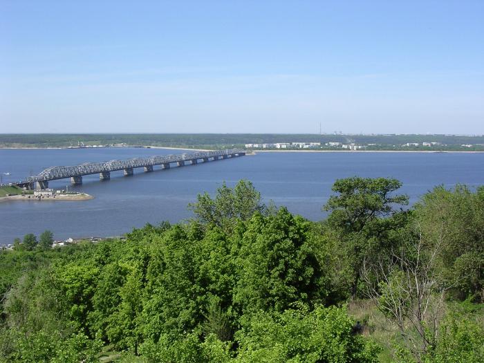
The river is conventionally divided into three large sections. These are the Upper, Middle and Lower Volga. The first large city on the path of the water flow is Rzhev. From the source it is 200 km. The next major settlement is the ancient Russian city of Tver with a population of more than 400 thousand people. Here is the Ivankovskoye Reservoir, whose length is 120 km. Next is the Uglich reservoir with a length of 146 km. North of the city of Rybinsk is the Rybinsk Reservoir. This is the most northern point great river. Then it no longer flows to the northeast, but turns to the southeast.
A water stream once carried its waters here along a narrow valley. It crossed a series of hills and lowlands. Now these places have turned into the Gorky Reservoir. On its banks are the cities of Rybinsk, Yaroslavl, Kostroma, and Kineshma. Above Nizhny Novgorod is the regional administrative center of Gorodets. The Nizhny Novgorod hydroelectric power station was built here, forming the Gorky Reservoir, stretching for 427 km.
The Middle Volga begins after reunification with the Oka. This is the largest right tributary. Its length is 1499 km. It flows into the great Russian river in Nizhny Novgorod. This is one of largest cities Russia.

Volga on the map
Having absorbed the waters of the Oka, the Volga River becomes wider and rushes to the east. It flows along the northern part of the Volga Upland. Near Cheboksary, her path is blocked by the Cheboksary Hydroelectric Power Station and forms the Cheboksary Reservoir. Its length is 341 km, width is 16 km. After this, the flow of the river shifts to the southeast, and near the city of Kazan it turns to the south.
The Volga becomes a truly powerful river after the Kama flows into it. This is the largest left tributary. Its length is 1805 km. The Kama is superior to the Volga in all respects. But for some reason it doesn’t flow into the Caspian Sea. This is due to historical names and traditions.
After reunification with the Kama, the lower reaches of the great Russian river begin. It is steadily moving south towards the Caspian Sea. On its banks there are cities such as Ulyanovsk, Togliatti, Samara, Saratov, Volgograd. Near Togliatti and Samara, the river forms a bend (Samara Luka), directed to the east. At this point the water flow goes around the Togliatti Mountains. Upstream is the largest reservoir on the river Kuibyshevskoye. In terms of area, it is considered the 3rd largest in the world. Its length reaches 500 km and its width is 40 km.

River pier in Saratov
Downstream beyond Samara is the Saratov Reservoir, reaching a length of 341 km. It is formed by a dam built near the city of Balakovo.
From Samara to Volgograd the river flows to the southwest. Above Volgograd, the left branch is separated from the main water flow. It's called Akhtuba. The length of the arm is 537 km. The Volzhskaya Hydroelectric Power Station was built between Volgograd and the beginning of Akhtuba. It forms the Volgograd Reservoir. Its length is 540 km, and its width reaches 17 km.
Volga Delta
The delta of the great Russian river begins in the Volgograd region. Its length is about 160 km, width reaches 40 km. The delta includes almost 500 canals and small rivers. This is the largest estuary in Europe. The Bakhtemir branch forms the navigable Volga-Caspian Canal. The Kigach River, which is one of the branches, flows through the territory of Kazakhstan. These places contain unique flora and fauna. Here you can find pelicans, flamingos, as well as plants such as lotus.

Such ships sail along the Volga
Shipping
The Volga River underwent significant transformations during Soviet times. Many dams were built on it taking into account navigation. Therefore, ships easily travel from the Caspian Sea to the northern regions of the country.
Communication with the Black Sea and the Don is carried out through the Volga-Don Canal. Communication with the northern lakes (Ladoga, Onega), St. Petersburg and the Baltic Sea is carried out through the Volga-Baltic waterway. The great river is connected to Moscow by the Moscow Canal.
The river is considered navigable from the city of Rzhev to the delta. A wide variety of industrial goods are transported along it. These are oil, coal, timber, food. During the 3 winter months, the water stream freezes along most of its path.
The Volga has a very rich history. Many important political events are inextricably linked with it. The economic importance of water flow is also disproportionate. It is the most important artery that unites many regions into a single whole. The largest industrial and administrative centers are located on its banks. There are as many as 4 millionaire cities alone. These are Kazan, Volgograd, Samara and Nizhny Novgorod. Therefore, the mighty waters are rightly called the great Russian river.
The Volga is located in the European part of Russia and ranks first among the longest Russian rivers and 16th position among the longest rivers of our planet. The big river takes its headwaters on the Valdai Hills and flows into the Caspian Sea. It is fed by snow, groundwater and storm flows.
The Volga has a calm, slow flow. The banks of the river serve as a wonderful place to relax, and more than 70 species of fish live in the water. Many of these fish species are commercial fish.
Length of the Volga River

The length of the largest river is 3530 km, the basin area is 1,360,000 km², and before they began to build reservoirs on it, the length was more than 3600 km. The source of the river is the Voldai Upland, and the mouth is the Caspian Sea. This is the largest river in the world, which flows into a closed reservoir, which is the largest closed lake ( Caspian Sea), annual flow is 254 km³.
The water artery of Russia passes through many regions of the country. Tver, Moscow, Yaroslavl, Kostroma, Ivanovo, Nizhny Novgorod, Ulyanovsk, Samara, Saratov, Volgograd, Astrakhan regions, as well as the republics of Chuvashia, Mari El, Tatarstan, are located on the banks of the water element. The upper flow is directed from the western part to the east, and the lower flow from the northern part to the south. It ends in the Caspian Sea.
Source of the Volga River

(The source of the Volga on the Volgoverkhovye)
The powerful water element takes its origins from a small stream of underground water, namely in the village of Volgoverkhovye. The village is located at a mountain height, more than 200 meters above sea level.
Many tourists are attracted by the small chapel, which is built on the spot where the river originates. Travelers love to share their impressions and say that they stepped across such a mighty river.

(Such a small but fast stream becomes a wide river with a long history)
Gradually, a small stream gains strength due to more than 100,000 tributaries, consisting of large and small rivers. Overcoming kilometers, the Volga transforms into a huge river.
Mouth of the Volga River

(The mouth of the Volga in the Astrakhan region is divided by many branches)
In the city of Astrakhan, the mouth of the Volga is formed, which is divided by many branches, among which the largest are Bakhtemir, Bolda, Buzan. Southern City on 11 islands on the upper coastal part of the river.
It was built at the confluence of the Volga unique reserve. Rare species flora and fauna are under state protection. The Astrakhan Nature Reserve attracts many travelers and amazes its guests with picturesque places.
Tributaries of the Volga River

(The magnificent confluence of the Oka and Volga)
The Volga can be roughly divided into three sections. The upper section begins at the source of the Volga and stretches to the end of the Oka. The middle part starts from the mouth of the Oka and ends at the mouth of the Kama. The lower section starts from the mouth of the Kama and ends at the mouth of the Volga. The upper reaches have large streams such as the Darkness, Unzha and Mologa. The middle reaches include Sura, Vetluga and Sviyaga. The lower reaches consist of Samara, Eruslan and Sok. Total tributaries is more than 500, as well as multiple channels and not big rivers.

(The confluence of the Kama River with the Volga forms the magnificent Kama estuary, Mount Lobach)
Among some scientists there is an opinion that the Kama River was the main river, and the Volga served as its tributary. Many studies show that the life activity of the Kama exceeds the Volga by several million years. In 1983, the Cheboksary reservoir was launched, and the Volga was reincarnated into many flowing lakes. And the Kama continues to be fed by the tributaries of small rivers.
Cities of Russia on the Volga River

(Volga along the city of Yaroslavl)
Some of Russia's most powerful cities are located on the banks of the Volga: Nizhny Novgorod, Kazan, Ulyanovsk, Samara and Volgograd. Administrative centers are economic, cultural, sports, industrial centers for Russian Federation.
Also no less important are the large cities on the river: Astrakhan, Saratov, Kharabali, Kineshma and many others. Along the river's route there are many settlements. Railroad and road routes have been created, so not a single tourist has any problems with the question of how to get to the mighty Volga. More than 1,400 marinas and industrial ports are located on its shores.

City dwellers and rural populations use the Volga for a variety of purposes. More than 40% of industrial production and more than 50% of agricultural production in the Russian Federation are concentrated in its waters and shores. The main function of the river is its economic role. Industrial materials, food and other necessary goods that improve people's livelihoods are transported along the river.
The Volga is also the main source of water supply for urban and rural populations. It also serves as a favorite place for active rest, tourism and fishing thanks to enough clean water and the colorful nature that surrounds its shores.
The Volga River in folk culture
Russia's favorite symbol is the powerful mother - the Volga River. She inspired and inspires hundreds of poets, singers and artists to create real masterpieces. It was about this river that songs and poems were composed for centuries, which completely glorified and continue to glorify it.
The Volga is also clearly depicted in paintings by world artists. The Volozhsk theme is regularly interpreted in a rich creative range and genre diversity. Hundreds of works by many nameless creators have survived to this day, depicting a variety of fragments of the great Volga River.
The Volga River is one of the greatest rivers in Russia and the longest and deepest in Europe.
The length of the river is 3530 km, and at the same time it is the longest among Russian rivers.
Many events in the history of our country are connected with the Volga.
Geographical characteristics
The Volga is the central water artery of the country and flows through its European part through the East European (Russian) Plain. This is the world's largest river flowing into an inland body of water. The area of the delta formed by the Volga is 19,000 square meters. km.
The great river originates from a small source of groundwater, located near the village of Volgoverkhovye and located at an altitude of 229 meters above sea level.
A small stream, receiving about 150,000 tributaries, including about 200 small and large rivers, gains power and strength and turns into a mighty river that flows into the Caspian Sea.
The fall of the river along its entire length does not exceed 250 meters, and the area of the basin is 1360 thousand square meters. km. The Volga River basin extends from the Urals on the eastern side to the Central Russian and Valdai Uplands in the west.
Hydrological regime
 The reservoir receives its main nutrition from melted spring waters.
Summer rains and groundwater, which feed the river in winter, play a slightly lesser role in its nutrition.
In connection with these features, three periods are distinguished in the annual river level: long and high spring floods, stable summer low water and low winter low water. The flood period averages 72 days.
The maximum rise in water is usually observed in the first half of May, that is, approximately two weeks after the spring ice drift. From June to October-November, summer low water is established, coinciding with the navigation period. It is at this time, when the river is free of ice, that navigation is possible. The Volga is one of the most important waterways in Russia.
Three sections of the river are conventionally distinguished:
- Upper Volga - from the source to Nizhny Novgorod (the mouth of the Oka).
- Middle Volga - from the mouth of the Oka to the mouth of the Kama.
- Lower Volga - from the mouth of the Kama to the Caspian Sea.
The Upper Volga extends mainly in the forest zone, flowing through large forests, while the route of the middle part of the river runs through the forest-steppe belt. The Lower Volga makes its way in the steppe and semi-desert zones. The bottom of the Volga in different places can be sandy or muddy, and muddy-sandy areas are often found. On the rifts the soil is mostly pebbly or gristly.
The maximum temperature of the river at the peak of summer reaches 20–25 degrees; in winter, the river along its entire length is covered with ice: the upper and middle parts freeze until the end of November, the lower Volga - at the beginning of December. The appearance of reservoirs on the river entailed a change in the thermal regime of the Volga. Thus, on the upper dams the period of ice captivity increased, and on the lower dams it decreased.
Nature of the Volga basin
 The Volga floodplain is complex and varied. Its flora and fauna are most diverse in the area of the lower Volga, at the mouth of the reservoir, the unique natural complex of which is represented by 1,500 species of insects, almost 50 species of fish, more than 900 species of plants, 3 species of amphibians, 33 of mammals, 250 of birds, 10 of reptiles.
That is why the unique Astrakhan Biosphere Reserve was founded in the Volga delta, many rare animals, birds and fish of which are listed in the Red Book of the Russian Federation, as well as in the International Red Book.
White-tailed eagle, pelican, great egret, and mute swan are found here. In the thickets along the banks of the Volga you can see wild boar, seals are preserved on the seashore, and saigas are preserved on the steppe plains. One of the world's largest bird migration corridors runs through the Volga delta.
The Volga is one of the richest rivers in Russia, the waters of which contain about 80 species of fish: sturgeon, pike, burbot, beluga, catfish, carp, ruffe, bream, whitefish and many others. Commercial fishing for many species is widespread. Since ancient times, the Volga River was considered one of the best places For fishing.Thanks to its unique natural resources and geographical location The river has long attracted people to its banks, where they built their settlements, which over time turned into large and small cities with surrounding villages. The development of shipping contributed to the emergence of trading cities - ports located along the entire course of the river. The largest of them are Volgograd, Samara, Kazan, Nizhny Novgorod.
Since the 30s of the last century, the Volga began to be used as a source of hydropower. Nowadays, approximately 50% of the agricultural production of the Russian Federation is concentrated in the river basin. The Volga provides more than 20% of the country's entire fishing industry. 9 reservoirs and hydroelectric power stations were built here. Therefore, it becomes quite acute.
According to experts, the load on the river’s water resources is eight times higher than the national average, and 65 of the 100 most polluted cities in Russia are located in the Volga basin.
Environmentalists are sounding the alarm: the waters of the Volga are seriously polluted. Monitoring data confirm that the water quality in the Volga and its tributaries and reservoirs does not meet the Russian quality standard for a number of parameters. The most serious ones arise in connection with:
- the presence of a large number of dams;
- the work of large industrial enterprises and complexes;
- the abundance of polluted wastewater from large cities;
- intensive navigation.
Impact of wastewater
 The main cause of river pollution is the discharge of untreated and insufficiently treated wastewater. The reason for this lies in physical and technological wear and tear and, as a consequence, the inefficiency of treatment facilities of industrial and municipal enterprises.
The pollution of the Volga water directly affects the condition of its inhabitants. Data from various studies have shown the presence of mutations and congenital deformities in some fish populations.
water bloom
The appearance of blue-green algae in the river was also noted, capable of actively absorbing oxygen during decomposition and releasing environment up to 300 types of toxic substances, most of which have not yet been studied. About 20–30% of the water surface of the Kuibyshev Reservoir is covered with a film of these algae every year in summer. After dying, the algae that fall to the bottom release phosphorus and nitrogen, thereby creating an ideal environment for self-reproduction, which results in secondary pollution of the reservoir.
Presence of dams
 According to experts, the situation is complicated by the fact that after the construction of the dams the river lost its ability to cleanse itself.
The Volga reservoirs are virtually non-flowing, and 90% of the pollution that enters them is not carried out by the current and settles at the bottom.
In addition, during the construction of these hydraulic structures,
The Volga is one of the important rivers of the world. It carries its waters through the European part of Russia and flows into the Caspian Sea. The industrial importance of the river is great, 8 hydroelectric power stations were built on it, shipping and fishing are well developed. In the 1980s, a bridge was built across the Volga, which is considered the longest in Russia. Its total length from source to mouth is about 3,600 km. But due to the fact that it is not customary to take into account those places that belong to reservoirs, the official length of the Volga River is 3530 km. Among all the water streams in Europe, it is the longest. Large cities such as Volgograd and Kazan are located on it. That part of Russia that is adjacent to the central artery of the country is called the Volga region. The river basin covers a little more than 1 million km2. Volga occupies a third of the European part of the Russian Federation.
Briefly about the river
The Volga is fed by snow, groundwater and rainwater. It is characterized by spring floods and autumn floods, as well as low water content in summer and winter.
The source and mouth of which freeze and become covered with ice almost simultaneously, in October-November, and in March-April it begins to thaw.
Previously, back in ancient centuries, it was called Ra. Already in the Middle Ages, mentions of the Volga appeared under the name Itil. The current name of the water stream comes from a word in the Proto-Slavic language, which is translated into Russian as “moisture”. There are also other versions of the origin of the name Volga, but it is not yet possible to confirm or refute them.
Source of the Volga
The Volga, whose source originates in the Tver region, begins at an altitude of 230 m. In the village of Volgoverkhovye there are several springs that were combined into a reservoir. One of them is the beginning of the river. In its upper course it flows through small lakes, and after a few meters it passes through the Upper Volga (Peno, Vselug, Volgo and Sterzh), on this moment combined into a reservoir.
A tiny swamp, which appearance It hardly attracts tourists - this is the source of the Volga. A map, even the most accurate one, will not have specific data about the beginning of the water flow.

Mouth of the Volga
The mouth of the Volga is the Caspian Sea. It is divided into hundreds of branches, due to which a wide delta is formed, the area of which is about 19,000 km 2. Due to the large amount of water resources, this area is the richest in plants and animals. The fact that the mouth of the river ranks first in the world in the number of sturgeons already speaks volumes. This river has quite an influence on climatic conditions, which have a beneficial effect on the plant and animal world, as well as on humans. The nature of this area is fascinating and helps to have a pleasant time. The best time to fish here is from April to November. The weather and the number of fish species will never allow you to return empty-handed.

Vegetable world
The following types of plants grow in the waters of the Volga:
- amphibians (susak, reed, cattail, lotus);
- aquatic submerged (naiad, hornwort, elodea, buttercup);
- aquatic with floating leaves (water lily, duckweed, pondweed, nut);
- algae (hari, cladophora, hara).
The largest number of plants is represented at the mouth of the Volga. The most common species are sedge, wormwood, pondweed, spurge, saltwort, and astragalus. Wormwood, sorrel, reed grass and bedstraw grow in large quantities in the meadows.
The delta of the river called the Volga, the source of which is also not particularly rich in plants, has 500 different species. Sedge, spurge, marshmallow, wormwood and mint are not uncommon here. You can find thickets of blackberries and reeds. Meadows grow on the banks of the water stream. The forest is located in stripes. The most common trees are willow, ash and poplar.

Animal world
The Volga is rich in fish. It is home to many aquatic animals that differ from each other in their mode of existence. In total there are about 70 species, of which 40 are commercial. One of the smallest fish in the pool is the tadpole, the length of which does not exceed 3 cm. It can even be confused with a tadpole. But the largest one is the beluga. Its dimensions can reach 4 m. It is a legendary fish: it can live up to 100 years and weigh more than 1 ton. The most important are roach, catfish, pike, sterlet, carp, pike perch, sturgeon, and bream. Such wealth not only provides products to nearby areas, but is also successfully exported to other countries.
Sterlet, pike, bream, carp, catfish, ruffe, perch, burbot, asp - all these fish representatives live in the inlet stream, and the Volga River is rightfully considered their permanent place of residence. The source, unfortunately, cannot boast of such rich diversity. In places where the water flow is calm and shallow, the southern stickleback lives - the only representative of sticklebacks. And in those areas where the Volga has the most vegetation, you can find carp, which prefers quiet waters. Sevruga, herring, sturgeon, lamprey, and beluga enter the river from the Caspian Sea. Since ancient times, the river has been considered the best for fishing.
You can also find frogs, birds, insects and snakes. Dalmatian pelicans, pheasants, egrets, swans and white-tailed eagles are very common on the banks. All these representatives are quite rare and are listed in the Red Book. There are many protected areas on the banks of the Volga, which help protect against extinction. Geese, ducks, teals and mallards nest here. Wild boars live here, and saigas live in the nearby steppes. Very often on the seashore you can find them quite freely located near the water.

The importance of the Volga for Russia
The Volga, whose source is in a village in the Tver region, flows throughout Russia. Through its waterway, the river connects with the Baltic, Azov, Black and White seas, as well as the Tikhvin and Vyshnevolotsk systems. In the Volga basin you can find large forests, as well as rich adjacent fields sown with various industrial and grain crops. The lands in these areas are fertile, which contributed to the development of gardening and melon growing. It should be clarified that in the Volga-Ural zone there are gas and oil deposits, and near Solikamsk and the Volga region there are salt deposits.
One cannot argue with the fact that the Volga has a large and rich history. She is a participant in many important political events. It also plays a huge economic role, being the main water artery of Russia, thereby uniting several regions into one. It is home to administrative and industrial centers and several millionaire cities. That is why this water stream is called the great Russian river.