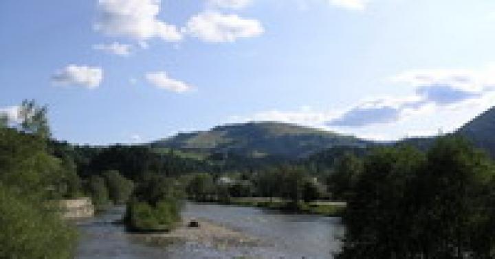
Let's say right away that Cape Good Hope this is not the southernmost point of Africa. But he is definitely the most famous in all of it south coast.
In the era of the Great Geographical Discoveries (from the end of the 15th century), ships, skirting the continent, changed course for the first time, turning east towards the Indian Ocean, right here. Therefore, people considered this cape to be the southernmost. Since then, science has stepped forward and clarified that in fact Cape Agulhas, located 150 km to the southeast, should be considered the southern point of the mainland. And the Cape of Good Hope bears the honorary title of the most southwestern point of the African continent.
Cape of Good Hope on the map
- Geographic coordinates -34.357890, 18.475453
- The distance from the capital of South Africa, Pretoria, is approximately 1340 km
- Distance to nearest international airport Cape Town about 45km
An interesting fact is that there are 3 capitals in South Africa. Pretoria is the official capital of the state. But the parliament is in Cape Town, and the supreme court is in Bloemfontein. And these cities are also called capitals. This is explained as follows: at the beginning of its formation, South Africa was a confederation, which included 3 territories - the Republic of South Africa (Pretoria), the possessions of Britain (Cape Town), and a country with the very exotic name of the Orange Free State (Bloemfontein). When South Africa was formed, it was decided to distribute authorities evenly across these cities.
Let us return to the Cape of Good Hope. Initially it was called the Cape of Storms. And for good reason.
The history of the name is as follows:
Europeans were looking for a sea route to India. For this purpose, in the middle of the last millennium, an expedition set out from Portugal. And in 1488, Captain Bartolomeo Dias rounded this cape for the first time. But these guys failed to get to India, because the team was tired and rebelled. Dias was forced to turn back. On the way back, a storm raged in the area of the cape. The ship and its crew were pretty battered. The sailor did not invent an original name, calling the rocky ledge simply Cape of Storms. A little later, King Juan II of Portugal decided to rename it the Cape of Good Hope, rightly believing that such a name would not only not scare off other sailors, but would also give them hope for a quick completion of the journey.
The king's initiative paid off. Already in 1497, Vasco Da Gama paved the way from the Old World to India. The expedition was successful, and since then the name Cape of Good Hope has been firmly attached to this rocky outcrop. Many sailors began to use this route.
Yes, of course, the souls of the sailors were filled with hope when approaching this cape, because more than half of the journey was behind them. Joy spread across the faces of the team. But no matter how amazing and bewitching the Cape of Good Hope attracts attention, it is quite dangerous for sailors. Storms and storms are quite normal for these places. To this day, about three dozen sunken ships can be seen in the surrounding waters.
To facilitate navigation, a lighthouse 238 meters high above sea level was built in 1857. But it turned out to be too high, and sometimes clouds and fog completely covered it.
 Old lighthouse Cape of Good Hope
 After another shipwreck in 1911, a decision was made to move the lighthouse. From 1913 to 1919, the lighthouse was built in a different place and not so high. The new lighthouse rises only 87 meters above sea level. But it can be seen from a distance of more than 60 km. This is the most powerful lighthouse on the entire southern coast of Africa. Since then, the sea route in the area of the cape has become much safer.
 New Cape of Good Hope Lighthouse
 There is an interesting misunderstanding. In fact, ships, passing from the Atlantic to the Indian Ocean, round Cape Point, located a little further. But it is the Cape of Good Hope that enjoys worldwide fame.
Behind Cape Point is a cozy Falsbay Bay, similar to Hawaiian Hanauma Bay. There is a beautiful beach washed by the warm current of the Indian Ocean.
Excellent beaches on the border of two oceans, stunning views of the surrounding area, and the diversity of flora and fauna in the Cape of Good Hope area attract a huge number of tourists.
Cape of Good Hope in photographs


The Cape of Good Hope is the most extreme point of southwestern Africa. It is located on the Cape Peninsula and is washed on two opposite sides by the waters of the Indian and Atlantic Oceans. Many people say that in calm weather you can see how the two parts of the body of water differ in color.
In ancient times, due to large waves and constant winds, the rocky cliff was called the Cape of Storms; later King Juan II renamed it the Cape of Good Hope. He truly was the hope of the Portuguese navigators who were heading to India. Today this is reminded by the largest lighthouse in South Africa (240 m above sea level), built in 1860.
In the vicinity of the rocky coast there is a reserve of the same name. Due to the vegetation, it is almost impossible to get there by car.
There are beaches on the cape where you can relax and sunbathe.
Sasha Mitrakhovich 06.04.2016 08:52

Cape of Good Hope(Cape of Good Hope) is famous for having long been considered the southernmost point of Africa. Then they calculated that the southernmost point of the continent is Cape Agulhas, located one and a half hundred miles to the southeast from the Cape of Good Hope.
But no one knows Cape Agulhas, but the Cape of Good Hope is included in all school geography textbooks; it is associated with the era of the Great Geographical Discoveries; hundreds of thousands of tourists and travelers from all over the world strive to see it.

Sasha Mitrakhovich 06.04.2016 08:56
It is known that the first European to see this African Cape of Good Hope was in 1488 Bartolomeo Dias, the famous Portuguese commander of the era of the Great Geographical Discoveries.

The expedition of Bartolomeo Dias was given the task of finding a sea route to India around Africa. Dias did not reach India, but became the first European to circumnavigate Africa from the south. Indirectly, he was helped in this by the terrible storms that battered his ships for several days. When the storms subsided, the disorientated Dias headed north and on February 3, 1488 ran into the coast, which “turned” to the northeast.
And so the way to the Indian Ocean was opened. Dias was forced to give in to the demands of the rebellious team and did not go further. On the way back, he saw this cape protruding into the sea, which he called the Cape of Storms, because severe storms were constantly raging in this place.

Dias announced this “working” name upon his return to Portugal in his report to King João II. But His Majesty was wise and far-sighted. He decided that it was not good to leave such a harsh name for the turning point, beyond which a direct sea route to India opened. And he suggested calling this place the Cape of Good Hope. Or in Portuguese Cabo de Boa Esperanca.
The cape lived up to its name. In 1497, Vasco da Gama's expedition rounded the Cape of Good Hope and finally reached the treasured shores of India!
Sasha Mitrakhovich 06.04.2016 09:01

Today it is the territory of the Cape Province of the Republic of South Africa. Nearest Big city Cape Town. The Cape of Good Hope itself is the national pride and tourist attraction of South Africa. It fits organically into national park or a reserve with the same name “Cape of Good Hope” or in English “Cape of Good Hope”.

As already mentioned, the Cape of Good Hope is not only not the southernmost, but also not the most southwestern point of Africa. The most southwestern point is the completely inconspicuous ledge of Cape Point, located fifty meters to the north. And it is on it that a lighthouse with the name “Cape of Good Hope” is installed. And an observation deck from where all tourists take their memorable photos.
And at the Cape of Good Hope there is a shield with the name and exact coordinates and the inscription “the most southwestern point of Africa.”
Location of the Cape of Good Hope on the World Map:
Sasha Mitrakhovich 06.04.2016 09:04

You can get to the Cape of Good Hope, located on the Cape Peninsula, from Cape Town. The journey by car will take about four hours. Time will pass unnoticed, because along the way you will encounter a very beautiful area: a savannah where ostriches, antelopes, baboons and other animals roam, mountains, a nature reserve.
The Cape of Good Hope is the most southwestern point of Africa. It is impossible to make a mistake, since this fact is confirmed by both scientists and an inscription with exact coordinates installed on the site in front of the cape. But the Cape Peninsula at this point reaches its most southern point and, going north, ends at Cape Point.
Excursions to the Cape of Good Hope
Typically, excursions to the Cape of Good Hope include a visit to the reserve, as well as the shore with a penguin haven. We'll tell you about a few more places that are worth seeing. On the coast of False Bay, or “False Bay,” a winding road is laid through the mountains. Along it you can get to the town of Simon's Town, where the British Royal Navy was previously based.
The coast of the Cape of Good Hope itself has its own characteristics. For example, on the western side the climate is milder, there are beaches, sandy shores, atmosphere of peace and tranquility. In the east it is warmer, but strong winds blow, which make it difficult to swim and enjoy the scenery. On this part of the coast, not everyone takes the risk of swimming; tourists prefer to just sit on the shore and breathe the ocean air.
The island of fur seals is of great interest to travelers. Its area is only 4 square kilometers- small for the island, and it traces its turbulent history to the 17th century. The fact is that for three centuries there was a prison here, military base and a hospital. And it was on this island that freedom fighter and future South African President Nelson Mandela served his sentence. In 1999, the island became a UNESCO World Heritage Site. A museum has opened here, telling about the history of the country. Tourists can visit the prison yard and cells.
You can get to the island by ferry, which leaves Waterfront every day until 15:00. On average, the excursion lasts 3.5-4 hours.
Sasha Mitrakhovich 06.04.2016 09:25
It is the embodiment of the hopes of Portuguese sailors who were looking for a way to India in the 15th century. Initially it was nicknamed the Cape of Storms, but King Juan II was very superstitious and issued a decree to rename it.
Today the cape is the most important strategic site in the region. Previously, it was a landmark for merchant ships traveling from Europe to the countries of the Far East. Now it's popular tourist place, whose landscapes are visited annually by millions of travelers from different corners planets.
Cape of Good Hope: description, photo, video
Despite the euphonious name, this section of the African coastal zone cannot be called calm. The Cape of Good Hope in South Africa often experiences strong sea storms and hurricanes, which is facilitated by two deep-sea currents that collide in the vicinity of the peninsula. For many centuries, these places were dangerous for navigation, just like in the area; even modern ships have a very difficult time passing this area. Only experienced sailors could cope with the power of the elements.
Quite often the Cape of Good Hope is called extreme point Africa in the south, but this is not entirely true. Geographically, a similar status belongs to Cape Agulhas, located 200 kilometers towards the southeast. The Cape of Good Hope is more of a “psychological” mark, after crossing which the traveler moves more in an eastern direction rather than a southern one. It rises 250 meters above sea level, making it one of the largest coastal cliffs in the world.
The Cape of Good Hope area in South Africa has dense vegetation with low bushes. Its entire territory, as well as the main part of the Cape Peninsula, are components National Park"Table Mountain". The climate here is harsh, wild and practically untouched by man. It is this feature that attracts tourists.
The total area of the protected area covers more than 7 thousand hectares. There are fantastic deserted beaches and majestic rocks, looking into the endless expanses of the ocean. The amazing landscapes of Cape Dobraya Nadezhny are just as mesmerizing in photos, but it’s better to see them in reality. The coast is home to simply a huge number of seabirds, among which penguins are especially interesting. As for vegetation, among the great diversity, it is full of endemics that are not found anywhere else in the world.
Where is the Cape of Good Hope

This attraction is located on the territory of the Republic of South Africa in the Western Cape. To be more precise, where the Cape of Good Hope is located, it is located 50 kilometers from Cape Town, in the area of another cape called Cape Point. This territory is notable for the fact that there is a so-called passage between two oceans - the Indian and Atlantic.
Distance from major cities:
- Pretoria - 1340 kilometers;
- Johannesburg – 1397 kilometers.
Coordinates of the Cape of Good Hope on the map:
- Latitude – 34° 21′ 32″
- Longitude — 18° 28′ 21″
Cape of Good Hope on the map
How to get to the Cape of Good Hope

The natural attraction is quite remote from civilization. You can get here from Cape Town, where there are many flights from Johannesburg and other cities. It is worth noting that different airlines flights operate only on certain days. The cost of a ticket depends on the distance - from major cities in South Africa it varies between 50-200 dollars, from other countries it is correspondingly more expensive.
How to get from Cape Town to the Cape of Good Hope:
The first option is suitable for those who have a driver's license; in the city you can rent a car for up to $120 per day, travel time is about 1.5 hours. You can also get there by bus; two flights depart to the cape daily – in the morning and at lunchtime. The landing point in Cape Town is Green Market Square, return buses leave at 13:00 and 17:15, the price of a one-way ticket is 7-8 dollars.
When is the best time to visit

Since the territory is under protection, the Cape of Good Hope has a specific work schedule. In summer it is open to visitors until 6 pm, in winter – until 5 pm. There are practically no days off. There are several beaches on the coast where you can come to relax and sunbathe. Many beaches are wild, so you can get away from tourists here. The cape is great for a family holiday.
The swimming season here begins in September and lasts until May. At this time the weather is warm and sunny. In winter, which here lasts from June to the end of July, it is cool here and strong winds blow. This time is suitable only for true extreme sports enthusiasts who are not scared by huge waves.
Features of visiting the Cape of Good Hope
Has an official website where you can learn a lot useful information. The cost to enter the park is approximately $11. For children under 11 years old there is a 50% discount. The Flying Dutchman funicular operates on site. It received this name due to the fact that the mysterious ship of the same name is most often visible from it.
According to legend, in the 17th century, a captain sold his soul to the devil to get out of a storm. As a result, the ship and crew members were cursed and forced to float forever in the ocean, appearing before the sailors who were about to suffer a misfortune. The cost of a one-way ride on the funicular is 4 dollars, and for children under 16 years old - 1.5.

 How to get to the Cape of Good Hope on your own

Vehicles that do not leave the parking lot before the park closes will be fined. It is also prohibited to litter within the park. There is a restaurant in the park where you can have a snack. local dishes, as well as several retail outlets where you can purchase souvenirs and other products. However, it is better to stock up on food and water in advance. You should also definitely take a camera with you - beautiful pictures are guaranteed.
What to see in the area
One of the main attractions of the cape is the lighthouse. It was built in the second half of the 19th century. The lighthouse rises 240 meters, so it can be seen from almost anywhere in the area. It is the largest in South Africa. Today it is not functioning and is more valuable from an aesthetic point of view, being an excellent observation deck. You can get here on foot or by cable car.
From the observation deck you can simultaneously admire the waters of two oceans, which, by the way, differ from each other in color. On the coast of False Bay in the mountains there is a winding path along which you can walk to the small town of Simon's Town. The British Royal Navy was once stationed here.
Another place that is definitely worth seeing is the island of fur seals. On 4 square kilometers there is a closed military base and a prison where Nelson Mandela served his sentence. Now there is a museum where you can learn the history of South Africa. Tourists also have the opportunity to visit the prison cells and courtyard.
Cape of Good Hope (South Africa) - detailed description, location, reviews, photos and videos.
- Last minute tours in South Africa
- Tours for May Worldwide
Previous photo
Next photo


The Cape of Good Hope represented the hopes of the Portuguese who were looking for a route to India in the 15th century. It was originally called the Cape of Storms, but King John II was superstitious and therefore decided to rename this point on the Cape Peninsula. Today the Cape of Good Hope is one of the important strategic sites of the African continent. He once helped ships get from Europe to Far East, now remains popular for its scenery, which attracts millions of tourists.
How to get there
You can get to the Cape of Good Hope, located on the Cape Peninsula, from Cape Town. The journey by car will take about four hours. Time will pass unnoticed, because along the way you will encounter a very beautiful area: a savannah where ostriches, antelopes, baboons and other animals roam, mountains, a nature reserve.
The Cape of Good Hope is the most southwestern point of Africa. It is impossible to make a mistake, since this fact is confirmed by both scientists and an inscription with exact coordinates installed on the site in front of the cape. But the Cape Peninsula at this point reaches its southernmost point and, going to the north, ends with Cape Point.
Reserve
The road to the Cape of Good Hope inevitably leads through the reserve of the same name. It is characterized by lush vegetation, which interferes with movement if traveling on foot. The highest density of plants is on the Cape Peninsula. It is almost impossible to get through here; you need a car. The area of the reserve is more than 7 thousand hectares. Here you can find plants that cannot be found in other parts of the world.
The vegetation and fauna of the reserve match its uniqueness in the fact that penguins live here next to monkeys, cheetahs and antelopes. Yes, yes, it’s the penguins that we are used to seeing only in the coldest parts of the planet. The fact is that they were able to swim to Africa from Antarctica and settled here.
Previously, penguins felt almost like the owners of the reserve and calmly went to their neighbors in search of food. But then, apparently, when other animals got tired of such anarchy, penguins received a separate territory. It's called Boulders Beach.
The reserve is open every day, seven days a week. In summer it receives guests until 18:00, and in winter - until 17:00 local time.
Cape of Good Hope and surroundings
Beaches
The Cape of Good Hope has beaches where you can relax and sunbathe. People come here both in large groups and with the whole family. There are even places on the beach where lovers can retire and hide from prying eyes.
The swimming season usually lasts from September to May. During this period, the weather is sunny, so you can safely go here to get a tan. On other days there is nothing special to catch on the beach.
Lighthouse
The lighthouse is one of the main attractions of the Cape of Good Hope. It was built in 1860 and its height is 240 meters above sea level. In South Africa this is the most high lighthouse. Unfortunately, it does not work, because one day it could not help the Portuguese ship - the lighthouse was covered with clouds, and the ship, which did not see the signal, landed on the rocks.
But at the lighthouse at an altitude of 200 meters there is an observation deck. You can climb it on foot or by cable car. Next to the lighthouse there is a restaurant and a souvenir shop.
The site offers a wonderful view of two oceans at once: the Indian and the Atlantic. The waters of these oceans wash both sides of the cape. If you look closely, you can see that the oceans are different in color. The waves run very quickly onto the rocks and break against them, leaving traces of white foam.
Excursions
Typically, excursions to the Cape of Good Hope include a visit to the reserve, as well as the shore with a penguin haven. We'll tell you about a few more places that are worth seeing. On the coast of False Bay, or “False Bay,” a winding road is laid through the mountains. Along it you can get to the town of Simon's Town, where the British Royal Navy was previously based.
The coast of the Cape of Good Hope itself has its own characteristics. For example, on the western side the climate is milder, there are beaches, sandy shores, and an atmosphere of peace and tranquility. In the east it is warmer, but strong winds blow, which make it difficult to swim and enjoy the scenery. On this part of the coast, not everyone takes the risk of swimming; tourists prefer to just sit on the shore and breathe the ocean air.
The island of fur seals is of great interest to travelers. Its area of only 4 square kilometers is small for an island, and it has a turbulent history dating back to the 17th century. The fact is that for three centuries there was a prison, a military base and a hospital. And it was on this island that freedom fighter and future South African President Nelson Mandela served his sentence. In 1999, the island became a UNESCO World Heritage Site. A museum has opened here, telling about the history of the country. Tourists can visit the prison yard and cells.
There is no place on the world map more mysterious than the Cape of Good Hope: shipwrecks, exotic animals and plants, unusual nature and climate - all this attracts thousands of tourists from all over the world like a magnet every year.
The Cape of Good Hope is located in the South-West of the African continent and is southern part Cape Peninsula. At 45 m north of the cape Good Hope meets another Cape Point. Geographically, the Cape of Good Hope belongs to the Atlantic basin, but is washed by two oceans from different sides: the Atlantic and Indian.
The eastern part of the Cape is always colder due to the Antarctic Current. The opposite coast of the cape is washed by the warm waters of Fels Bay, formed by the Indian Ocean. Due to the collision of cold and warm waters, strong air currents are formed around the cape, giving rise to strong winds and storms in the sea.
Highest point Cape is Mount Table (Table Mountain), its height is 1086 m. Near the Table there are the mountains Devil's Peak (height - 1000 m), Lion's Head (670 m), 12 Apostles and Signal Hill (350 m).
Table Mountain near the Cape of Good Hope
Table Mountain is listed world heritage UNESCO is a symbol nearby city Cape Town.
The mountain owes its name to its unusually flat peak. Thanks to which, the Table resembles a table. Not every tourist is able to see the mountain, as it is often covered with clouds. Locals They call this phenomenon “tablecloth.”
In good weather the mountain is visible from Cape Town. From the city you can climb to the top of the mountain along cable car, or on foot. At the top there is an observation deck and telescopes. This gives you a bird's eye view of Cape Town and the ocean. The mountain is composed of sandstones, it has steep slopes covered with vegetation.
History of the formation of the Cape of Good Hope
The Cape of Good Hope is located on the African Plate and is part of the coastal spit of the Cape Peninsula. The history of the appearance of the Cape of Good Hope is inextricably linked with the formation of the African continent. The Cape took shape during the Triassic period, after the separation of Africa from Pangea. 
At that time, this land was not a cape at all, but a small island. Over a long period of time, the ocean deposited sand between the island and the mainland, slowly connecting them.
Locals call this phenomenon "Africa's Helping Hand." During the Ice Age, the Cape of Good Hope, like the entire southern part of Africa, was covered with ice.
People began to inhabit southern Africa during the Stone Age, as evidenced by numerous cave paintings. Nearby in Cape Town were discovered rock paintings cape
Explorations of the Cape of Good Hope
The Cape of Good Hope appeared on the world map during the Age of Discovery. Interest in the cape stems from the East India Company, which required a sea trade route from Europe to India. Like all the greats geographical discoveries The Cape of Good Hope was discovered by accident.
The discoverer of the cape is considered to be the navigator of Portuguese origin Bartolomeu Dias. All the men in the Dias family were engaged in navigation, so Bartolomeu was well acquainted with navigation and ship control; already at the age of 30 he became a ship captain on state pay. 
In 1487, the Portuguese king Juan II ordered to equip a naval expedition of three ships, two of which were military sailing ships. The goal was to find a new route to India through Africa. A year later, they reached the southern hemisphere of the Earth and began their journey along the shores of the African continent.
Unbearable heat and a storm raging off the coast of Africa forced Dias to change course and set sail for 2 weeks open sea. After the storm subsided, the ships returned to their usual course and reached the southern part of the continent. Ahead was the Indian Ocean and a direct path to the shores of India.
However, Dias failed to reach its shores. The crew began to demand to return home due to dwindling supplies, scurvy and very hot weather. The captain decided to return in 3 days.
During these three days, the ship managed to reach Cape Agulhas and go around it. On the last day of their journey, Dias and his team rounded an unknown cape and turned back. Dias named it the Cape of Storms because strong winds blew around it. The Cape of Good Hope appeared on the world map thanks to Juan II. Upon returning to his homeland, Dias presented a report to the king, who did not like the name Cape of Storms.
It was decided to rename the cape His Majesty the Cape of Good Hope. The name, which was too long, did not catch on and was changed to the Cape of Good Hope. This name was supposed to give hope to sailors heading to the shores of India. 
For 5 long years, no one searched the coast of India. Interest in it awoke only after the discovery of America by Christopher Columbus. King Juan II again orders an expedition through Africa. In 1498, Vasco da Gama rounded the Cape of Good Hope and headed for the shores of India.
Dias later made attempts to reach the Cape of Good Hope, but whether he succeeded in his plans is unknown. Dias's ship went missing southern shores Africa. After which a legend was born that the ship forever wanders off the coast of the cape it discovered. Perhaps this story served as the prototype for the famous tale of the Flying Dutchman, a ghost ship.
The path to India past the coast of Africa was laid, but the Portuguese were not interested in exploring it. The first European settlements in these areas were organized by the Dutch in 1652. It was they who began to study the cape, the population living in these parts and nature.
The pilgrims managed to find out that historically the area of the cape belonged to the Hottentot tribe, a relative of the Bushmen tribe. It was the Dutch pioneers who founded the city of Cape Town near the cape, the name of which can be translated as “proud on the cape.”
Cape Town began to prosper as all the ships rounding the Cape of Good Hope docked at the port to resupply. The cape became an outpost of the East India Company on its way to India.
In 1657, the Hottentots, dissatisfied with slavery and the taking of land by Europeans, started a war. The excitement was suppressed by the Europeans. In 1795, the settlement could not resist the onslaught of Napoleon and the territory, along with the cape, went to France. 
The Cape of Good Hope disappeared from the world map in 1796. That year, Great Britain ousted the French, and the Cape became known as the “Provincial Colony of Good Hope.” These territories would later become part of the Union of South Africa.
The British managed to find gold deposits near the cape and organize diamond mines, to which adventurers from all over the world flocked. Cape Town has become the main city in Africa. Only in 1961, the Cape of Good Hope, as part of the Union, became the independent Republic of South Africa (RSA) and regained its name.
Climatic conditions
The climate at the Cape of Good Hope is marine subtropical. It’s not for nothing that the peninsula got its name Cape of Storms. The wind blows strong here and does not stop throughout the year. In summer the wind has a south-easterly direction, and in winter – northwest. The best time Spring is considered the best time for tourists to explore the Cape of Good Hope.
In the southern hemisphere it occurs in September-November. In spring, the cape begins to become covered with greenery, there is little precipitation and temperature regime allows you to enjoy a walk around the cape.
The Cape of Good Hope heats up in summer warm currents Indian Ocean.
This is a hot and dry season with little rainfall. Summer on the Cape lasts from December to March. average temperature in summer 25 °C, but in some years the temperature exceeded 40 °C - this is the absolute temperature maximum. 
Autumn at the Cape of Good Hope occurs between April and May. This is a pleasant and not hot time to travel. At this time you can fully appreciate the beauty of the local nature.
The greatest amount of precipitation on the cape falls in winter in June-August. In June last year, 122 mm Hg fell. Art.
This is the rainiest and cloudiest month of the year. The wind, which constantly blows on the cape during the rainy season, intensifies, remaining warm.
Average temperature for the last 3 years:
| Month | January | February | March | April | May | June | July | August | September | October | November | December |
| Average temperature during the day, 0 C | 26 | 26 | 24 | 22 | 19 | 16 | 16 | 17 | 19 | 21 | 22 | 24 |
| Average temperature at night, 0C | 18 | 18 | 17 | 15 | 14 | 11 | 10 | 11 | 12 | 14 | 15 | 17 |
| Cloudiness, % | 13 | 13 | 18 | 24 | 27 | 33 | 28 | 31 | 29 | 23 | 20 | 17 |
Flora and fauna
The Cape of Good Hope on the world map does not have the best location. But from the point of view of the natural map of the world, this area is unique.
Only here there are signs warning car owners: “When starting the car, make sure there are no penguins under it.”
It’s hard to believe, but on such a small piece of land, animals whose habitats are hundreds of kilometers apart coexist peacefully. Only at the Cape of Good Hope you can meet monkeys, zebras, penguins and ostriches in one place in just a few hours of walking. 5% of all animal and plant species on the planet can be seen in South Africa.
The most frequent guests of the cape are marine inhabitants. Off the coast of the Cape of Good Hope you can meet entire colonies of fur seals, and see sharks and whales swimming past. Since the cape goes deep into the sea, its shore becomes an excellent viewing platform for observing these amazing sea creatures. 
One of the symbols of the cape are fur seals. These are small pinnipeds that are black or brown in color. Not far from Cape Town you can see the island of fur seals. According to various estimates, from 50 to 70 thousand seals live on it. The island looks more like flat rocks with water sticking out on them, on which fur seals live. Previously, poachers caught seals for the production of fur coats; now this is officially prohibited and the animals are under the protection of the South African authorities. 
The monkey family on the island is represented by baboons, who are so accustomed to living among people that they are not afraid of their presence. Tourists often try to feed the animals, so the South African authorities were forced to put up signs with the following content: “Baboons are wild and dangerous animals.”
There are even employees on the island who drive animals away from tourists with sticks. Baboons belong to the monkey family and are very similar in appearance. The height of baboons reaches 75 cm. The usual habitat of baboons is East and Central Africa.
On the way to the cape, you can meet elephants and herds of antelope, which still live in the Republic of South Africa. African ostriches can be found not only on special farms, but also in the wild. They are the only remaining members of the ostrich family in South Africa. The height of birds can reach more than 2.5 m, and their weight exceeds 150 kg. 
An encounter with an ostrich can be dangerous for a tourist. In total, about 850 bird species live permanently in South Africa and the Cape of Good Hope. On the cape you can easily find the nests of some of them.
Penguins are a favorite among tourists. Their population on the Indian Ocean coast is large. They scurry around everywhere, their main habitat is Boulders Beach.
Local authorities decided to give the beach to the penguins. The cape is home to spectacled penguins, which are listed in the International Red Book. These penguins are also called donkey penguins because of their ability to make sounds similar to the “ey” of a donkey. 
2/3 of the flora of the Cape of Good Hope consists of rare plant species that cannot be found in any other corner of the world. Most of The cape is occupied by the Fynbos biome, consisting mainly of rare species of shrubs. There are about 9 thousand species here.
Good Hope Reserve
The reserve is considered not only the main attraction of the cape, but also of South Africa itself. Its area is more than 7 hectares of land. You can get to the reserve from Cape Town by car or rent a bicycle. The journey by car will take about 1.5 hours. The road to the Cape of Good Hope is laid through the territory of the reserve. There is an ostrich farm nearby. 
The Cape of Good Hope remains the most unique in terms of quantity unique species animals, a point on the world map. Not so long ago, scientists from the UK proved this. The reserve presents all animals and plants living on the Cape Peninsula and in South Africa.
The history of the reserve began recently, in 1938. By that time, more than 1,000 different species of animals and several thousand plants already lived on the territory of the reserve. 
In this place are rare species animals that are found only on the territory of the reserve and animals brought from all over South Africa. Hyenas, rhinoceroses, ostriches, crocodiles, penguins, giraffes, zebras, antelopes, elephants - all of them can be found in the reserve. 
The reserve is open daily for tourists, the only limitation being bad weather conditions. During storms and storms, tourists are prohibited from visiting the park and the Cape of Good Hope. The most popular among tourists are fur seals and penguins, who are happy to be photographed and are not afraid of humans.
Cape Beaches
During the swimming season, when on the coast good weather tourists are allowed to swim on the beaches of the cape and sunbathe. The swimming season lasts from September to May.
It is worth remembering that the cape is washed on both sides by different oceans, so the temperature in the western part is always a little lower, but there are sandy entries into the water and the waves are calm.
 The eastern coast is warmer, but gusty winds constantly blow there and formations big waves. The beaches in this part are more suitable for walking and contemplating the ocean.


There are no blank spots left on the world map thanks to people like Bartolomeu Dias, who spent their entire lives for one discovery. Cape of Good Hope - extraordinary a nice place, filled with the romance of wanderings. The edge of the earth that everyone should see.
Article format: Mila Friedan
Video about the Cape of Good Hope
Penguins in Africa: