Sakhalin island
Sakhalin- an island off the east coast of Asia. It is part of the Sakhalin Oblast, the largest island in the Russian Federation. It is washed by the Sea of Okhotsk and the Sea of Japan. It is separated from mainland Asia by the Tatar Strait (in the narrowest part, the Nevelskoy Strait, it is 7.3 km wide and freezes in winter); from the Japanese island of Hokkaido - by the La Perouse Strait.
The island got its name from the Manchu name of the Amur River - "Sakhalyan-ulla", which means "Black River" - this name, printed on the map, was mistakenly attributed to Sakhalin, and in further editions of the maps it was already printed as the name of the island. The Japanese call Sakhalin Karafuto, this name goes back to the Ainu "kamuy- kara-puto-ya-mosir", which means "the land of the god of the mouth".
In 1805, a Russian ship under the command of I.F. Kruzenshtern explored most of the coast of Sakhalin and concluded that Sakhalin is a peninsula. In 1808, Japanese expeditions led by Matsuda Denjuro and Mamiya Rinzo proved that Sakhalin was an island. Most European cartographers were skeptical of the Japanese data. Long time on different maps Sakhalin was designated either an island or a peninsula. Only in 1849 did the expedition under the command of G. I. Nevelsky put an end to this issue, passing on the military transport ship Baikal between Sakhalin and the mainland. This strait was subsequently named after Nevelskoy.
Geography
The island is elongated meridionally from Cape Crillon in the south to Cape Elizabeth in the north. The length is 948 km, the width is from 26 km (the Poyasok isthmus) to 160 km (at the latitude of the village of Lesogorskoye), the area is 76.4 thousand km².

Map of Sakhalin Island 1885
Relief
The relief of the island is composed of medium-altitude mountains, low mountains and low plains. The southern and central parts of the island are characterized mountainous terrain and consist of two meridionally oriented mountain systems - the West Sakhalin (up to 1327 m high - Onor) and the East Sakhalin mountains (up to 1609 m high - Lopatina), separated by the longitudinal Tym-Poronai lowland. The north of the island (with the exception of the Schmidt Peninsula) is a gentle hilly plain.
The shores of the island are slightly indented; large bays - Aniva and Patience (widely open to the south) are located respectively in the southern and middle parts of the island. IN coastline there are two large bays and four peninsulas.
In the relief of Sakhalin, the following 11 regions are distinguished:
- The Schmidt Peninsula (about 1.4 thousand km²) is a mountainous peninsula in the far north of the island with steep, sometimes steep coasts and two meridional ridges - Western and Eastern; the highest point is Mount Three Brothers (623 m); connected to the North Sakhalin Plain by the Okha Isthmus, the width of which at its narrowest point is just over 6 km;
- The North Sakhalin Plain (about 28 thousand km²) is a gently undulating area south of the Schmidt Peninsula with a widely branched river network, weakly pronounced watersheds and separate low mountain ranges, stretches from Baikal Bay in the north to the confluence of the Nysh and Tym rivers in the south, the highest point is Daakhuria (601 m); north East Coast the islands are distinguished as a subarea, which is characterized by large lagoons (the largest are Piltun, Chaivo, Nyisky, Nabilsky, Lunsky bays), separated from the sea by narrow strips of alluvial spits, dunes, low sea terraces - it is in this subarea and on the adjacent shelf of the Okhotsk the seas are the main Sakhalin oil and gas fields;
- The West Sakhalin Mountains stretch for almost 630 km from the latitude with. Hoe (51º19 "N) in the north to the Crillon Peninsula in the extreme south of the island; the average width of the mountains is 40-50 km, the largest (at the latitude of Cape Lamanon) is about 70 km; the axial part is formed by Kamyshovy (north of the isthmus Belt) and South Kamyshovy ridges;
- The Tym-Poronai lowland is located in the middle part of the island and is a hilly-ridged lowland stretching for about 250 km in the meridional direction - from Terpeniya Bay in the south to the confluence of the Tym and Nysh rivers in the north; reaches its maximum width (up to 90 km) at the mouth of the Poronay River, the minimum (6-8 km) - in the valley of the Tym River; in the north it passes into the Nabil lowland; covered with a thick cover of Cenozoic sediments, composed of sedimentary deposits of the Quaternary period. sandstones, pebbles; the heavily swampy southern part of the lowland is called the Poronai "tundra";
- The Susunai lowland is located in the southern part of the island and stretches for about 100 km from Aniva Bay in the south to the Naiba River in the north; from the west, the lowland is bounded by the West Sakhalin Mountains, from the east - by the Susunai Range and the Korsakov Plateau; in the southern part, the width of the lowland reaches 20 km, in the center - 6 km, in the north - 10 km; absolute heights in the north and south do not exceed 20 m above sea level, in the central part, on the watershed of the Susuya and Bolshoi Takaya river basins, they reach 60 m; refers to the type of internal lowlands and is a tectonic depression filled with a large thickness of Quaternary deposits; within the Susunai lowland are the cities of Yuzhno-Sakhalinsk, Aniva, Dolinsk and about half of the island's population lives;
- The East Sakhalin Mountains are represented in the north by the Lopatinsky mountain junction (the highest point is the city of Lopatina, 1609 m) with ridges extending radially from it; two spurs of the opposite direction represent the Nabil Range; in the south, the Nabilsky Range passes into the Central Range, in the north, sharply lowering, into the North Sakhalin Plain;
- the lowlands of the Patience Peninsula - the smallest of the districts, occupies most of the Patience Peninsula east of Patience Bay;
- The Susunai Range stretches from north to south for 70 km and has a width of 18-120 km; the highest points are Mount Pushkinskaya (1047 m) and Chekhov Peak (1045 m); composed of Paleozoic deposits, at the foot of the western macroslope of the ridge is the city of Yuzhno-Sakhalinsk;
- The Korsakov plateau is bounded from the west by the Susunai lowland, from the north by the Susunay ridge, from the east by the Muravyovskaya lowland, from the south by Aniva Bay, has a slightly undulating surface formed by a system of flat-topped ridged ridges elongated in a northeast direction; at the southern end of the plateau on the shores of Aniva Bay is the city of Korsakov;
- The Muravyovskaya lowland is located between Aniva bays in the south and Mordvinov bays in the north, has a ridged relief with flat tops of the ridges; within the lowlands there are many lakes, incl. the so-called "Warm Lakes", where people from South Sakhalin like to go on vacation;
- The Tonino-Aniva Range stretches from north to south, from Cape Svobodny to Cape Aniva, for almost 90 km, the highest point is Mount Kruzenshtern (670 m); composed of Cretaceous and Jurassic deposits.

View of the Sea of Okhotsk from the high shore near the lighthouse in the area of the Warm Lakes
Climate
The climate of Sakhalin is cool, moderately monsoonal (the average temperature in January is from -6ºС in the south to -24ºС in the north, in August - from +19ºС to +10ºС, respectively), maritime with long snowy winters and short cool summers.
The following factors influence the climate:
- Geographical position between 46º and 54º N. latitude. determines the arrival of solar radiation from 410 kJ/year in the north to 450 kJ/year in the south.
- The position between the Eurasian continent and the Pacific Ocean determines the monsoonal nature of the climate. A humid and cool, rather rainy Sakhalin summer is associated with it.
- Mountainous terrain affects the direction and speed of the wind. A decrease in wind speed in intermountain basins (in particular, in the relatively large Tym-Poronai and Susunai lowlands) contributes to cooling the air in winter and warming it in summer, it is here that the greatest temperature contrasts are observed; while the mountains protect the named lowlands, as well as West Coast from exposure to the cold air of the Sea of Okhotsk.
- In summer, the contrast between the western and eastern coasts of the island is enhanced by the respectively warm Tsushima Current of the Sea of Japan and the cold East Sakhalin Current of the Sea of Okhotsk.
- The cold Sea of Okhotsk affects the climate of the island like a giant thermal accumulator, determining a long cold spring and a relatively warm autumn: snow in Yuzhno-Sakhalinsk sometimes lasts until mid-May, and the flower beds of Yuzhno-Sakhalinsk can bloom until early November. If we compare Sakhalin with similar (in terms of climatic indicators) territories of European Russia, then the seasons on the island succeed each other with a delay of about three weeks.
Air temperature and precipitation in Yuzhno-Sakhalinsk in the 21st century (temperature: II.2001-IV.2009; precipitation: III.2005-IV.2009):
| Options / Months | I | II | III | IV | V | VI | VII | VIII | IX | X | XI | XII | Year |
|---|---|---|---|---|---|---|---|---|---|---|---|---|---|
| Maximum air temperature, ºС | 1,7 | 4,1 | 9,0 | 22,9 | 25,0 | 28,2 | 29,6 | 32,0 | 26,0 | 22,8 | 15,3 | 5,0 | 32,0 |
| Average air temperature, ºС | −11,6 | −11,7 | −4,6 | 1,8 | 7,4 | 12,3 | 15,5 | 17,3 | 13,4 | 6,6 | −0,8 | −9,0 | 3,2 |
| Minimum air temperature, ºС | −29,5 | −30,5 | −25,0 | −14,5 | −4,7 | 1,2 | 3,0 | 4,2 | −2,1 | −8,0 | −16,5 | −26,0 | −30,5 |
| The amount of precipitation, mm | 49 | 66 | 62 | 54 | 71 | 38 | 37 | 104 | 88 | 96 | 77 | 79 | 792 |
The maximum temperature on Sakhalin (+39ºС) was noted in July 1977 in the village. Border on the east coast (Nogliki district). The minimum temperature on Sakhalin (-50ºС) was recorded in January 1980 in the village. Ado-Tymovo (Tymovsky district). The registered temperature minimum in Yuzhno-Sakhalinsk is -36ºС (January 1961), maximum - +34.7ºС (August 1999).
The highest average annual precipitation (990 mm) falls in the city of Aniva, the smallest (476 mm) - at the Kuegda meteorological station (Okhinsky district). The average annual amount of precipitation in Yuzhno-Sakhalinsk (according to long-term data) is 753 mm.
The earliest stable snow cover appears on Cape Elizaveta (Okhinsky district) and in the village of Ado-Tymovo (Tymovsky district) - on average October 31, the latest - in Korsakov (on average December 1). The average dates of snow cover melting are from April 22 (Kholmsk) to May 28 (Cape Elizabeth). In Yuzhno-Sakhalinsk, stable snow cover appears on average on November 22 and disappears on April 29.
The most powerful typhoon in the last 100 years (“Phyllis”) hit the island in August 1981. The maximum precipitation then occurred on August 5-6, and in total from August 4 to 7, 322 mm of precipitation fell in the south of Sakhalin (about three monthly norms) .
Inland waters
The largest rivers of Sakhalin:
| River | Administrative region(s) | Where does it flow | Length, km | Basin area, km² | Average annual runoff, km³ |
|---|---|---|---|---|---|
| Poronai | Tymovsky, Smirnykhovsky, Poronaysky | Gulf of Patience, Sea of Okhotsk | 350 | 7990 | 2,49 |
| Tym | Tymovsky, Nogliksky | Nyisky Bay of the Sea of Okhotsk | 330 | 7850 | 1,68 |
| Naiba | Dolinsky | Gulf of Patience, Sea of Okhotsk | 119 | 1660 | 0,65 |
| Lutoga | Kholmsky, Anivsky | Aniva Bay of the Sea of Okhotsk | 130 | 1530 | 1,00 |
| Shaft | Nogliki | Chayvo Bay of the Sea of Okhotsk | 112 | 1440 | 0,73 |
| Ainu | Tomarinsky | lake Ainu | 79 | 1330 | ... |
| Nysh | Nogliki | Tym river (left tributary) | 116 | 1260 | ... |
| Charcoal (Esutoru) | Uglegorsky | Sea of Japan (Tatar Strait) | 102 | 1250 | 0,57 |
| Langeri (Langry) | Okhinsky | Amur Estuary of the Sea of Okhotsk | 130 | 1190 | ... |
| Big | Okhinsky | Sakhalin Bay of the Sea of Okhotsk | 97 | 1160 | ... |
| Rukutama (Vitnica) | Poronai | lake Nevsky | 120 | 1100 | ... |
| reindeer | Poronai | Gulf of Patience, Sea of Okhotsk | 85 | 1080 | ... |
| Lesogorka (Taimyr) | Uglegorsky | Sea of Japan (Tatar Strait) | 72 | 1020 | 0,62 |
| Nabil | Nogliki | Nabil Bay of the Sea of Okhotsk | 101 | 1010 | ... |
| Malaya Tym | Tymovsky | Tym river (left tributary) | 66 | 917 | ... |
| Leonidovka | Poronai | Poronay river (right tributary) | 95 | 850 | 0,39 |
| Susuya | Yuzhno-Sakhalinsk, Anivsky | Aniva Bay of the Sea of Okhotsk | 83 | 823 | 0,08 |
There are 16120 lakes on Sakhalin with a total area of about 1000 km². The areas of their greatest concentration are the north and southeast of the island. The two most large lakes Sakhalin - Nevsky with a mirror area of 178 km² (Poronaisky district, near the mouth of the Poronai River) and Tunaicha (174 km²) (Korsakovsky district, in the north of the Muravyovskaya lowland); both lakes belong to the lagoon type.
Natural resources
Sakhalin has a very high potential natural resources. In addition to biological resources, in terms of reserves of which Sakhalin is one of the first places in Russia, hydrocarbon reserves are very large on the island and its shelf. In terms of explored reserves of gas condensate, the Sakhalin Region ranks 4th in Russia, gas - 7th, coal - 12th and oil - 13th, while within the region, the reserves of these minerals are almost entirely concentrated in Sakhalin and his shelf. Other natural resources of the island include timber, gold, platinum.
Flora and fauna
Both the flora and fauna of the island are depleted both in comparison with the adjacent areas of the mainland and in comparison with the located south of the island Hokkaido.
Flora
As of the beginning of 2004, the flora of the island includes 1521 species of vascular plants belonging to 575 genera from 132 families, with 7 families and 101 genera represented only by invasive species. The total number of alien species on the island is 288, or 18.9% of the composition of the entire flora. According to the main systematic groups, vascular plants of the Sakhalin flora are distributed as follows (excluding adventitious ones): vascular spores - 79 species (including lycopods - 14, horsetails - 8, ferns - 57), gymnosperms - 9 species, angiosperms - 1146 species ( including monocots - 383, dicots - 763). The leading families of vascular plants in the flora of Sakhalin are sedge ( Cyperaceae) (121 species excluding aliens - 122 species including aliens), Compositae ( Asteraceae) (120 - 175), cereals ( Poaceae) (108 - 152), rosaceous ( Rosaceae) (58 - 68), ranunculus ( Ranunculaceae) (54 - 57), heather ( Ericaceae) (39 - 39), clove ( Caryophyllaceae) (38 - 54), buckwheat ( Polygonaceae) (37 - 57), orchids ( Orchidaceae) (35 - 35), cruciferous ( Brassicaceae) (33 - 53).
Fauna

Pink salmon goes to spawn in a nameless river that flows into Mordvinov Bay
"Red Book"
The fauna, flora and mycobiota of the island include many rare protected species of animals, plants and fungi. 12 mammal species recorded on Sakhalin, 97 bird species (including 50 nesting species), seven fish species, 20 invertebrate species, 113 vascular plant species, 13 bryophyte species, seven algae species, 14 fungi species and 20 lichen species (t ie 136 species of animals, 133 species of plants and 34 species of fungi - a total of 303 species) have protected status, i.e. listed in the Red Book Sakhalin region", while about a third of them are simultaneously included in the" Red Book Russian Federation".
Of the "federal Red Book" flowering plants, the flora of Sakhalin includes Aralia heart-shaped ( Aralia cordata), calypso bulbous ( Calypso bulbosa), Glen's cardiocrinum ( Cardiocrinum glehnii), Japanese sedge ( carex japonica) and lead gray ( C.livida), lady's slippers real ( Cypripedium calceolus) and large-flowered ( C. macranthum), Gray's double leaf ( Diphylleia grayi), leafless chin ( Epipogium aphyllum), Japanese kandyk ( Erythronium japonicum), high paunch ( Gastrodia elata), iris xiphoid ( Iris ensata), walnut ailantolium ( Juglans ailanthifolia), calopanax seven-lobed ( Kalopanax septemlobum), tiger lily ( lilium lancifolium), Tolmachev's honeysuckle ( Lonicera tolmatchevii), long-legged winged seed ( macropodium pterospermum), miyakiya whole-leaved ( Miyakea integrifolia) (miyakia is the only endemic genus of vascular plants on Sakhalin), nest flower ( Neottianthe cucullata), peonies obovate ( Paeonia obovata) and mountainous ( P. oreogeton), bluegrass rough ( Poa radula) and Viburnum Wright ( Viburnum wrightii), i.e. 23 types. In addition, eight more "federal Red Book" plants are found on the island: two types of gymnosperms - Sargent's juniper ( Juniperus sargentii) and yew spiky ( taxus cuspidata), three species of ferns - Asiatic half-grass ( Isotes asiatica), Mikel's leptorumora ( Leptorumohra miqueliana) and Wright's mecodium ( Mecodium wrightii), two species and one variety of mosses - Japanese bryoxiphium ( Bryoxiphium norvegicum var. japonicum), northern necker ( Neckera borealis), and plagiothecium obtuse ( Plagiothecium obtusissimum).
Population
According to the results of the 2002 census, the population of the island was 527.1 thousand people, incl. 253.5 thousand men and 273.6 thousand women; about 85% of the population are Russians, the rest are Ukrainians, Koreans, Belarusians, Tatars, Chuvashs, Mordovians, several thousand people each of representatives of the indigenous peoples of the North - Nivkhs and Oroks. From 2002 to 2008 the population of Sakhalin continued to slowly (by about 1% per year) decline: mortality still prevails over births, and attracting labor from the mainland and from countries neighboring Russia does not compensate for the departure of Sakhalin residents to the mainland. At the beginning of 2008, about 500 thousand people lived on the island.
The largest city of the island is the regional center Yuzhno-Sakhalinsk (173.2 thousand people; 01.01.2007), other relatively large cities are Korsakov (35.1 thousand people), Kholmsk (32.3 thousand people), Okha (26.7 thousand people), Nevelsk (17.0 thousand people), Poronaysk (16.9 thousand people).
The population is distributed among the regions of the island as follows (results of the 2002 census, people):
| Area | All population | %% of total | Urban population | Rural population |
|---|---|---|---|---|
| Yuzhno-Sakhalinsk and subordinate settlements | 182142 | 34,6 | 177272 | 4870 |
| Aleksandrovsk-Sakhalinsky | 17509 | 3,3 | 14764 | 2746 |
| Anivsky | 15275 | 2,9 | 8098 | 7177 |
| Dolinsky | 28268 | 5,4 | 23532 | 4736 |
| Korsakovsky | 45347 | 8,6 | 39311 | 6036 |
| Makarovsky | 9802 | 1,9 | 7282 | 2520 |
| Nevelsky | 26873 | 5,1 | 25954 | 921 |
| Nogliki | 13594 | 2,6 | 11653 | 1941 |
| Okhinsky | 33533 | 6,4 | 30977 | 2556 |
| Poronai | 28859 | 5,5 | 27531 | 1508 |
| Smirnykhovsky | 15044 | 2,9 | 7551 | 7493 |
| Tomarinsky | 11669 | 2,2 | 9845 | 1824 |
| Tymovsky | 19109 | 3,6 | 8542 | 10567 |
| Uglegorsky | 30208 | 5,7 | 26406 | 3802 |
| Kholmsky | 49848 | 9,5 | 44874 | 4974 |
| Sakhalin as a whole | 527080 | 100 | 463410 | 63670 |
Story
Archaeological finds indicate that people appeared on Sakhalin in the Paleolithic, about 20-25 thousand years ago, when, as a result of glaciation, the level of the World Ocean dropped and land "bridges" were restored between Sakhalin and the mainland, as well as Sakhalin and Hokkaido. (Then on another land "bridge" between Asia and America, located on the site of the modern Bering Strait, Homo sapiens moved to the Americas). In the Neolithic (2-6 thousand years ago), Sakhalin was inhabited by the ancestors of modern Paleo-Asian peoples - the Nivkhs (in the north of the island) and the Ainu (in the south).
These same ethnic groups made up the main population of the island in the Middle Ages, with the Nivkhs migrating between Sakhalin and the lower Amur, and the Ainu between Sakhalin and Hokkaido. Their material culture was similar in many ways, and their livelihood was provided by fishing, hunting and gathering. At the end of the Middle Ages (in the 16th-17th centuries), Tungus-speaking peoples appeared on Sakhalin - Evenks (nomadic reindeer herders) and Oroks (Uilta), who, under the influence of the Evenks, also began to engage in reindeer herding.
According to the Shimodsky Treaty (1855) between Russia and Japan, Sakhalin was recognized as their joint indivisible possession. Under the St. Petersburg Treaty of 1875, Russia received ownership of the island of Sakhalin, in return transferring to Japan all the northern Kuril Islands. After the defeat of the Russian Empire in the Russo-Japanese War of 1904-05 and the signing of the Treaty of Portsmouth, Japan received South Sakhalin (part of Sakhalin Island south of the 50th parallel). As a result of the victory over Japan during World War II, the entire territory of Sakhalin Island and all the Kuril Islands were included in the Soviet Union (RSFSR). On the territory or part of the territory of about. Sakhalin currently has no claims from either Japan or any other country.
Yuzhno-Sakhalinsk was founded by Russians in 1882 under the name of Vladimirovka. After the victory of the USSR and its allies in World War II, together with the entire island, it passed to the USSR.
From Japanese, this area is translated as "the land of the god of the mouth", the Manchu language calls it "Sakhalyan-ulla". Initially, Sakhalin was identified on maps as a peninsula, but subsequent expeditions provided a lot of evidence in favor of the opinion that Sakhalin is still an island.
The harsh lands of Sakhalin are located east of the Asian coast. The island is the largest in the Russian Federation and is a neighbor of the Kuril Islands. A traveler who has visited these places remains deeply impressed for a long time. Natural monuments are the main treasure of the island.
Description and location of the island
The cold waters of the Sea of Okhotsk wash the territory of Sakhalin, warm waters are taken from the Japanese and Pacific Oceans. Treason, La Perouse and Soviet are the only border with the state of Japan. The distance from Sakhalin to the mainland is completely occupied by water.
The area of Sakhalin is 87 thousand square kilometers. This figure includes the islands of Tyuleniy, Ush, Moneron, the Kuril ridge with the Kuril archipelago.
From the extreme southern point of the island to the northern one, there are 950 km. The entire area of Sakhalin looks like a scaly fish (from the height of the ISS flight), where the scales are a lot of rivers and lakes scattered across the island.
Separates Sakhalin and the mainland. There are two capes in the strait, the width between which is about seven kilometers. For the most part, the coast is flat with numerous mouths of rivers that flow into the seas.
Story
The historical background of the island begins with the Early Paleolithic, about three hundred thousand years ago.
Today, more than 10,000 kilometers separate the Sakhalin area from the Russian capital. The plane flies through seven time zones before reaching the airport of the largest city, Yuzhno-Sakhalinsk.
Russian travelers in the 17th century often became pioneers, discovering new lands of their vast country. In the 50s of the 19th century, an expedition led by Nevelsky finally proved the Japanese theory that Sakhalin was an island formation. At the same time, the island was inhabited by peasants, and became the border point of Russia and Japan, so military posts were placed throughout the territory. The next 30 years turned this place into a colony where exiles were sent.
Treaties between Russia and Japan had a great impact on the study of the Sakhalin land. For ninety years, the Russian-Japanese border has changed four times. Due to the armed intervention by the Japanese in 1920, the entire area of Sakhalin was occupied. The troops were withdrawn only in 1925, and seven years later the island became part of the Far East, as the Sakhalin region.
Wandering from one country to another, the Kuriles finally returned to the Soviet Union after the Second World War. The modern border of the region was formed in 1947.
The capital of Sakhalin is the city of Yuzhno-Sakhalinsk, which was formed by settlers at the end of the 19th century.
Tourism on Sakhalin
The geography of Sakhalin and the Kuril Islands is a treasure trove of the Far East. Until now, the development of island attractions continues. The development of tourism, according to the authorities, should bring the region's economy to a qualitatively new level of development. About 60 travel companies operate on the island, and most of the tourists are from neighboring Japan. They are attracted by the diversity of not only natural, but also historical monuments. The authorities of the island also monitor the Japanese heritage left over from the occupation.
In recent years, ecotourism has begun to actively develop on Sakhalin. But given the fact that the Japanese are more focused on comfortable living conditions, then travel companies are limited to field trips, and hotels and hotels are increasingly improving the services provided. Almost all hotels have a menu with oriental dishes (including Japanese).
A program of hikes to Chekhov Peak is being implemented. The territories are being improved more and more, including the construction of a tourist complex in the village of Goryachiye Klyuchi and the Aquamarine tourist center. A project is being prepared for the construction of complexes near thermal mineral springs.

Of the sights, one can single out: the incredible beauty of the Bird's Lake; the partially destroyed Devil's Bridge; the largest waterfall on the island of Kunashir - Ptichy; active volcanoes Kuriles - Golovnin, Tyatya; lighthouse at Cape Aniva; the coast of the Sea of Okhotsk covered with white rocks; picturesque lake Tunaicha; Treasury of the nature of the Kuril Islands - Iturup Island; northern hot springs of the island; formation on the rocks Kunashir - Cape Stolbchaty; the southern point of the island is Cape Crillon; most beautiful waterfall on Russian territory - Ilya Muromets.
Population of Sakhalin
It has about 500 thousand multinationals, the population consists of Russians, Ukrainians, Belarusians, Koreans, Mordovians, Tatars, as well as indigenous people.

Includes several nationalities: Nivkhs, Tonchis, Evenks, Ainu, Nanai, Uilta. These are the inhabitants of these lands who lived on them before the establishment of modern borders. Indigenous peoples, unfortunately, are very few in number. However, they are still engaged in the development of their national economy and lead a national life.
Flora
Diversity among the flora and fauna of Sakhalin is not observed. Compared to the Japanese Islands, the territory of the Sakhalin Region is quite poor in terms of the number of flora and fauna representatives.
F. Schmidt began to study the flora of the island in the middle of the 19th century. At the moment, there are about 1,500 plant species on Sakhalin that have vessels for carrying water, dissolved mineral salts and other organic elements (vascular).
About seventy percent of Sakhalin is occupied by forests, despite the environmental problem of deforestation and annual fires, the north of the island is still occupied by coniferous trees. This area is considered dark coniferous taiga. New trees grow very slowly due to lack of sunlight. In order for a young tree to receive a good dose of sun, it has to wait until one of the old representatives of the forest falls and brings light into the dark taiga shroud.
There are, of course, light coniferous forests, but their representatives are mainly larches, which are not very common on the island. Why is this happening? The special soil is to blame for everything, under which clay layers are located. They do not allow water to pass through and, accordingly, do not allow trees to develop and grow well. And a very small part of the forest area is occupied by deciduous forests.
Sakhalin forests are rich in wild rosemary, which forms serious thickets and swamps. Of the berries, blueberries and cranberries are common here, and cloudberries grow in the swamps. There are many perennial herbs and shrubs.
Fauna
Allows forty-four species of mammals to live on the island. Bears, reindeer, otters, wolverines, raccoon dogs and a large number of rodents are common here, about 370 different types of birds, of which 10 are predators.

During the period of development of the island, a large amount of flora and fauna was destroyed by man, therefore, a rather long list of endangered animals and plants of Sakhalin has been included in the Red Book.
Industry
The Sakhalin industry is developing at a fairly rapid pace, it included the oil and gas production, coal, fishing and energy industries. Of course, the advantage for many years remains oil and gas production. Thanks to the developments of Sakhalin scientists, Russia entered the list of leading countries in the export of liquefied natural gas. Sakhalin provides gas to Japan, Thailand, Korea, Mexico and China.

The development of shelf deposits made it possible to improve the condition of roads, residential premises, and so on in terms of money. For the constant growth of the region's economy, work is underway to attract continuous investment in existing projects.
Climate of Sakhalin
The climatic conditions of the island are moderate monsoons, due to the direct proximity to the water. Winter here is quite snowy and long, and summer is cold. For example, January weather has strong northern winds and frost. Quite often you can get into a snowstorm. Snow avalanches are also not uncommon here, sometimes the winter wind reaches an incredible speed of hurricane force. In winter, the temperature drops to -40 degrees, and adjusted for the wind, even lower.
Summer on Sakhalin is short - from mid-June to early September with temperatures from 10 to 19 degrees above zero. It is quite rainy, the Pacific Ocean brings high humidity.
The warm current of the Sea of Japan flows in the southwest, while the eastern coast is washed by the Sea of Okhotsk with a cold current. By the way, it is the Sea of Okhotsk that dooms Sakhalin to cold spring weather. The snow usually doesn't melt until May. But there were also record highs of +35 degrees. In general, each season here comes with a three-week delay. Therefore, in August, the warmest days, and in February - the coldest.

The summer season brings floods to the island. In the 80s, Sakhalin suffered from a powerful typhoon. He left more than 4,000 people homeless. And in 1970, a typhoon poured more than a month's rainfall in a few hours. A fifteen-year-old typhoon brought mudslides and landslides. Usually such weather conditions come from the Pacific Ocean.
Geography and geology
The geographical relief of Sakhalin Island is determined by mountains of medium and low height, as well as flat areas. The West Sakhalin and East Sakhalin mountain systems are located in the south and in the center of the island. The north is represented by a hilly plain. The coast is marked by four peninsular points and two large bays.
The relief of the island consists of eleven areas: the Schmidt Peninsula is a land with a steep rocky coast and mountainous terrain; the plain of northern Sakhalin is a territorial area with hills and many river networks, it is here that the main oil and gas fields are located; mountains of the western part of Sakhalin; lowland Tym-Poronayskaya - located in the center of the island, its main part is swampy; Susunai lowland - located in the south and most of all populated by people; the eponymous ridge - Susunaisky, which includes the famous Chekhov and Pushkinsky peaks; mountains of eastern Sakhalin with the highest point - Mount Lopatin; peninsula of Patience with its lowlands; plateau Korsakovskoe; lowland Muravyovskaya, consisting of numerous lakes, popular among local residents; the Tonino-Anivsky ridge is famous for the Kruzenshtern mountain and its deposits of the Jurassic period.
Minerals
The first place among the natural resources of Sakhalin Island is occupied by biological ones, moreover, this niche brings the region to the first place in the Russian Federation. The island is rich in hydrocarbon reserves and coal deposits. In addition, Sakhalin produces a large amount of wood, gold, mercury, platinum, chromium, germanium and talc.
How to get to the mainland?
The distance from Sakhalin to the mainland of Russia can be overcome in several ways: by plane (for example, from the nearest city of Khabarovsk), by ferry from Vanino, and for extreme people in winter, you can overcome the water part on foot on frozen ice.
Considered the narrowest point between the mainland and the island, its width is about seven kilometers.
However, the island has interesting story frozen construction railway started under Stalin. Moreover, the trains had to pass through special tunnels through the already mentioned Cape Nevelskoy and Cape Lazarev. The construction of railway lines was carried out by convicts from Gulag prisons. Work progressed at a rapid pace, but the death of the leader completely stopped the project. Many prisoners were amnestied.
Surprisingly, not a single bridge has been built in all the past years. Therefore, modern developments begin precisely with the intentions of constructing bridge crossings. Moreover, Russia intends to connect Sakhalin with Japan for more fruitful cooperation between the regions.
The most interesting thing on Sakhalin is Sakhalin itself: the largest Russian island in terms of area (about the size of the Czech Republic) and population (490 thousand people), stretched strictly from north to south between the Sea of Okhotsk and the Tatar Strait. Its "pinpoint" sights are rather disappointing, especially in comparison with the Kuriles or Primorye. But the overall color overflows on every square meter. In I showed a couple of randomly selected villages, later I will write separate posts about Japanese heritage and unusual Sakhalin railways, and today - the nature, history and realities of Sokoliny Island.
On the map, Sakhalin cannot be confused with anything: if Italy looks like a boot, then this island is definitely a fish! Big fish - 948 kilometers from north to south and from 25 to 160 from west to east. A narrow head (Schmidt Peninsula) with an eye (Okha), a long back fin (Patience Peninsula), a narrow articulation of the body and tail (Girdle Isthmus) and a pair of caudal fins are clearly visible - the Crillon and Aniva Peninsulas. Below the inscription "Welcome!" the 50th parallel was drawn - the border of the North and the South, and in 1905-45 - our country with Japan. But almost the whole life of Sakhalin is at the tail, from the Belt to the base of Aniva and Crillon. From there there will be 3/4 "local" posts, and I just passed the middle of the island by night train.
1a. 
Visually, Sakhalin is quite homogeneous: from south to north, diversity in its nature only decreases. A cursory glance leaves the impression that in the North there is not much of what is in the South, but in the South there is almost everything that happens in the North. The details are much more excellent - cloudberries, lingonberries and even moss grow in the North, on which reindeer graze. But either we didn’t climb north enough (half the way from Noglik to Okha), or all this can be appreciated only by going deep into the forest.
Basically, Sakhalin looks like this along its entire length - winding coasts, dense vegetation and low wooded hills
2.
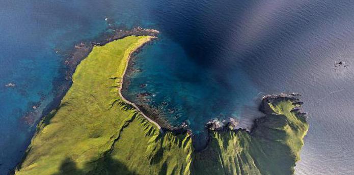
The relief of Sakhalin is unexpectedly soft - here you will hardly see rocks, boulders and sheer cliffs. The sight of the coast is not so much capes (although they also exist) or kekurs, but "lagoon-type bays", separated from the sea by thin sandy spits:
3.
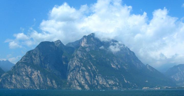
The Sakhalin mountains are lower than the Urals (the first hundreds of meters, the maximum is Mount Lopatin in the north, 1609m) and almost do not show peaks from the forests:
4.
Swampy dank swamps stretch along the rare plains - m A ri:
5.
There are no geysers or volcanoes on Sakhalin - but there are hot springs (as under an awning from the frame above) and mud volcanoes:
6.
Pay attention to the fog creeping along the peaks. As they say in the guidebooks: "The locals joke - if you don't like the weather, wait 10 minutes." This phrase has a continuation: "... and you will be completely disappointed." And I would also replace "10 minutes" with "10 kilometers": the night usually brought us new weather, but the map of Sakhalin was a bizarre mosaic of the sun, low clouds, winds, cold and warm rains and creeping fogs. Which is not surprising, if two seas approach the mountains ...
To the west of Sakhalin lies the Tatar Strait - formally part of the Sea of Japan, but in fact the sea itself, especially its width over a longer distance from 100 to 300 kilometers. There is a warm current along the coast of Sakhalin, so in August you can even swim here:
7.
From the east - the open Sea of Okhotsk, which the locals call the "refrigerator sea". But its icy water is extremely rich in life, and it is from the “refrigerator” that the Sakhalin people take red fish and crabs, and whales come to the lagoons in the north of the island.
8.
From the south, between the "caudal fins", Aniva Bay juts out. It refers to Sea of Okhotsk, but his son is obviously illegitimate - small, warm and very dirty in the inhabited part. But closer to the exit to the sea, it is not difficult to see killer whales.
9.
Perhaps the most impressive thing in the local nature is the vegetation, the abundance and riot of which Sakhalin looks like the planet Pandora. Moreover, that is why it is better to visit here not in September (when the weather is sunny), but in August, while all this abundance remains green and juicy.
10.
There is almost no real taiga on Sakhalin - its forest is mostly deciduous (less often larch, as in the frame above), transparent and completely passable:
11.
Mountains with their rapids add picturesqueness:
12.
Lianas climb along the birch trees:
And many plants seem completely unfamiliar to a person from the European part:
13.
14.
15.
The blue berries from the frame above, judging by the fact that no one picked them by August, are inedible.
But the bedbug is a small red berry that really smells like bedbugs. It is considered very useful (for example, it helps against pressure), and therefore it is perhaps the most expensive berry on sale in Russia - 1,000 rubles per kilogram. In addition to Sakhalin, bed bugs (or krasnik, as it is sometimes called in stores) grow on Iturup, and in the north of Primorye, closer to the coast, it is occasionally found. The berries themselves are unbearably sour, but the syrup in tea "de clope" pleased us until the end of the trip:
15a. 
But perhaps the most impressive property of Sakhalin herbs is gigantism. Hogweed (and not the infection from the research institute near Moscow, but quite authentically local ones) here grow from a small tree:
16.
If it rains in the mountains - just pick the burdock:
17.
Giant burdocks are one of the strongest impressions of Sakhalin. Especially when you consider that these are not actually burdocks, but a kind of coltsfoot - Japanese butterbur.
18.
It, like fern, is willingly harvested here for food, and pickled burdock tastes like meat:
18a. 
But the main grass of Sakhalin and the Kuriles is the bamboo plant:
19. Iturup 
In the frame above, Olya is not sitting, but standing in full growth. Bamboo, although a relative of bamboo, but not like it - high soft stems are crowned with wide, hard, noisily rattling leaves when walking. In principle, it is possible to wade through virgin bamboo, but you will have time to curse everything. If you walk along the path, then in fact you find it only by feeling, since the leaves close at chest level:
20. Kunashir 
Often the leaves are crossed from edge to edge by a dotted line of small holes - they are gnawed by insects in the spring, when a young and soft leaf is folded into a tube.
20a. 
Sakhalin "Pandora" is rich not only in vegetation. Of the animals, chipmunks most often catch the eye:
21a. 
A little less often - foxes:
21.
Eagles in the sky
22.
Underfoot - numerous vicious vipers. There are few mosquitoes in the local forests, but the tick is fierce in June-July, and spreads encephalitis in its especially harmful Japanese form.
23.
The men from Hohe told me that they hunted sable in the local forests. But here it is small and not too fluffy, so that not a single family can live here on sables alone, as in the depths of Siberia. Large forest animals, whether red deer, musk deer or bear, I saw only in the museum. There are almost no wolves on Sakhalin that cannot cope with deep loose snow in winter, but there are so many bears that my failure to meet them is more an exception than a rule.
24.
But perhaps the most interesting Sakhalin animal is not worth looking for in the forest, but in river water. This is kaluga - the world's largest freshwater fish (up to 6 meters long, up to 1 ton in weight) of sturgeons, also found in the lower reaches of the Amur. There is also the Sakhalin sturgeon - it is smaller, but its caviar was considered more valuable. But sturgeons here became scarce even earlier and deeper, their fishing has been prohibited since 1959, and I saw Kaluga only in the Vladivostok Aquarium.
25.
Grandfathers, on the other hand, smeared the “Sakhalin-style sandwich” with two types of caviar - red and black. There have also been fewer salmonids here (according to old-timers, a few decades ago, salmon was caught almost with bare hands in dachas near Yuzhno-Sakhalinsk), but many on Sakhalin still live from Putin to Putin. A typical dialogue with a Sakhalin citizen:
-Tell me, Muscovite, why is our fish so expensive!?
-Come on! 150-200 rubles for pink salmon - is it a lot?
- Well, you have 70!
- I've never seen anything like this, at least 300 rubles.
- Oh, okay.. We do not recognize fish for money at all!
Maritime departments of the South Sakhalin shopping centers"Success" and "Technician" are real fish markets, where Olya and I stocked up more than once:
26.
And not only fish: crabs, shrimps, octopuses, squids, scallops, trumpeters, trepangs and many other unknown marine reptiles in Moscow are sold here in any form from frozen to live, and most (except for caviar, scallop and trepang) are cheaper than in the cheapest Moscow stores, one and a half to two times. However, about the seafood of the Far East,.
27.
Along the roads where they go to the Sea of Okhotsk, sometimes you come across such crab markets from several trays. They exist quite officially, but their products are mostly poached and therefore cheap (500 rubles per kilo of crab, for example), and what kind of balance of interests works here - I'm even afraid to delve into it. The most famous crab markets are in the villages of Okhotskoye and Vzmorye, the second one is considered to be of better quality.
28.
Theoretically, on Sakhalin the soil is quite suitable for agriculture. Under the Soviets, the region provided not only itself, but also its neighbors with vegetables and milk, and in Japan it was the center for the production of sugar from beets. All this was abandoned in the 1990s, and farming is now only timidly rearing its head on the "Far Eastern hectares". A Sakhalin resident can grow a good garden, but they need to be dealt with in a specific way. For example, the best natural fertilizer here is fishmeal.
So more often Sakhalin residents prefer fishing to gardening:
29.
And of course, people with fishing rods on bridges and shores are only a small part of the fishing life.
30.
The seaside hinterland is literally hung with nets:
31.
Which are even used as hedges:
32.
But even where the sound of the sea is not heard, we cannot forget that we are on the island:
32a. 
And shells on Sakhalin are a kind of symbol of its first people: the most important archaeological sites of the Stone Age, "shell hills" serve here, going meters into the cultural layer. The first people appeared on Sakhalin tens of thousands of years ago, most likely during the Ice Age: the glaciers absorbed a huge amount of water, from which the level of the World Ocean fell by tens of meters. A land "bridge" grew up between the mainland and Sakhalin, and an even larger "bridge" of the Bering Isthmus connected Eurasia with America. The primitive hunters who lived on the coast of Okhotsk rushed along these bridges for new prey, giving rise to the Indians in America, and where they came from - scientists have argued for centuries. The latest technologies of genetic analysis have shown that the ancestral home of the Indians, abandoned by their ancestors about 25 thousand years ago -. When the ice melted, and having returned the water to the ocean, opened the bridges, on Sakhalin, the proto-Indians were cut off from the mainland, who remained in Eurasia and, thanks to their isolation, retained their identity in subsequent centuries.
33.
In the Japanese chronicles, the misihase barbarians appear, for the sake of expelling them from the island of Honshu to the north in the 7th century, even the worst enemies of the Yamato and Emishi briefly united. In Chinese chronicles, at about the same time, they are mentioned by jils - this is consonant with "gilyaki", an outdated name for the Nivkhs. In the legends of the Ainu, the Tons appear - a warlike people who lived even further north before them. Well, science knows the "Okhotsk culture", or rather a broader concept - the "Okhotsk historical and cultural community" that developed on the coasts between Hokkaido and Kamchatka about 3000 years ago. Here are her artifacts in the museum of Yuzhno-Sakhalinsk:
34.
However, the ice age built several more land "bridges" in the south. According to them, completely different people dispersed from Asia to Australia, Indonesia and the Japanese islands. The Japanese, with their eternal craving for aesthetics, gave names to all eras of their history, and the oldest of these was the Jomon era. Imperial chroniclers hardly knew its "bottom", and modern science has groped at the "depth" of 13 thousand years. Another native of Altai, the common ancestors of the Koreans and the Japanese, who built the state of Buyo on the mainland and discovered the Yayoi era on the islands, put an end to this primordial chaos. They settled on the island of Kyushu, bringing with them agriculture, trade and simple fortification. On the islands, the aliens encountered Emishi, literally "hairy people", in our words - barbarians.
The Japanese barbarian was bearded, clear-eyed, toothy, tattooed and wildly ferocious, in a word, he did not differ much from the ancient barbarian. The descendants of these barbarians were the Ainu - perhaps the most mysterious people of Eurasia, since science does not even know their approximate relatives either in language or in appearance. Japanese scientists believe that bearded men came here from Siberia and are descendants of its most ancient inhabitants, while European scientists were looking for Ainu ancestors among the natives of Taiwan and South China: allegedly, in ancient times, some went south, to Indonesia and Australia, others went north, putting the beginning of the Jomon culture, and all the connecting links have long since disappeared into the cultural layers. Be that as it may, Yayoi and Emishi began to fight literally from the first meeting, and it was in the wars with the Ainu that Japan was formed, which began with the state of Yamato. Yes, and there is a lot of Ainu blood in the Japanese - yet outwardly they are not even completely Mongoloids. Samurai by their origin are not knights, but serving Cossacks, who owned all the power in the dashing frontier in exchange for its protection.
For the first centuries, the Ainu were a superior enemy for the Japanese, but little by little the colonialists adopted their military art and gradually began to gain the upper hand. The struggle was hard, and I think if the Japanese had not been locked up by the sea, they would have sent the savages to hell three times and retreated. During its heyday in the 7th century, the Yamato controlled Kyushu, Shikoku, and only the southern half of Honshu. Only in the 11th century did the Japanese fully master their largest island. The Ainu retreated to Hokkaido, at that time the island of Ezo, which Japan tightly took up only several centuries later. By that time, the samurai was certainly stronger than the Emishi, and the Ainu had to retreat even further north - that is, to the Kuriles and Sakhalin.
Things of the medieval Ainu in the same museum:
35.
By the 17th century, Sakhalin became the land of two peoples who lived throughout its territory, but mostly at opposite ends. In Northern Sakhalin - the Nivkhs, the heirs of the Okhotsk culture, those very "non-leaving Indians" who lived as a typical small Siberian people:
36a. 
In South Sakhalin, there are the Ainu, who raised the Japanese in battles and are not like anyone else in the whole world, neither in language, nor in appearance, nor in culture.
36.
Some peoples sometimes penetrated into this strange little world from the west, from the fish mouth of the Amur. In Northern Sakhalin, in addition to the Nivkhs, there are Evenks and Oroks (Uilta) - one of the closely related peoples of the Amur region. On the Tatar Strait, the remains of fortresses of the 12th-13th centuries are known - Ako near Aleksandrovsk-Sakhalinsky and Siranusi on Cape Crillon. These were overseas colonies of either the Mongols, or rather, the Jurchens (Manchus), whose state the Mongols wiped off the face of the Earth. By the right of the Manchu heritage in the 17-19 centuries, Sakhalin considered China to be its territory, although the Chinese did not set foot on the island, most likely never.
The first foreigner who saw Sakhalin is reliably considered to be Maartin Garretsen de Vries, a Dutch navigator who arrived here in 1643 from Indonesia. A year later, Karafuto, as the Japanese called this coast, was explored by the samurai Murakami Hironori from the Matsumae clan, who ruled the conquered Hokkaido since 1605. In the same 1644, the explorer Vasily Poyarkov from distant Kashin wintered at the mouth of the Amur, and learned from the local Gilyaks that their relatives lived across the sea, on big island. Vasily Danilovich himself saw the island only from the shore, but in Russian historiography he remained its discoverer. For the first time, the Sakhalin Ainu and Nivkh saw a Russian person in 1746, and in 1790 Siranusi was revived as a Japanese trading post, the center of "sentana" - barter between the Japanese, Russians and natives. From the same museum - Japanese funa and Russian koch:
37.
In 1787, the French navigator Jean-Francois de La Perouse passed from Korea to Kamchatka, leaving a noticeable mark in the local toponymy - Crillon, Moneron, Jonquiere, Douai, and much more, as well as the naive European "Tatar Strait": "Tatars" are the Mongols , for which the Frenchman took the slanting natives on both sides of the strait. However, the La Perouse Strait separates Sakhalin from Hokkaido, and the depth, steadily decreasing as you move north, forced the commander to consider Sakhalin a peninsula. Ivan Kruzenshtern did not prove the opposite in 1805, but in fact the discoverer that Sakhalin is an island was in 1808 a Japanese surveyor with a Georgian name Renzo Mamiya. However, the map he compiled for a long time remained the property of the Land of the Rising Sun, and only in 1847 was published in Europe. Mamiya, however, traveled by boat, and there were still doubts that the strait was not a shallow, becoming a spit at low tide. The insurmountability of the strait on dry land and at the same time its navigability was proved in 1849 by Gennady Nevelskoy, and now he is one of the two most popular historical characters of Sakhalin. There are monuments to him in the cities, and this one is in the Japanese interiors of the same museum:
38.
The first Russian flag on Sakhalin was hoisted by Kruzenshtern, but in fact the island remained a nobody: the Chinese claims (officially lifted in 1859) were hardly taken seriously then, and both Japanese and Russians settled here at their own peril and risk. The first official Russian settlement in 1852 was Due, or simply the Sakhalin post on the Tatar Strait in the northern part of the island. In 1853, the Russian-American Company tried to gain a foothold here, but the Crimean War and the English fleet in the Sea of Okhotsk forced the evacuation of the Ilyinsky and Muravyovsky posts laid down in South Sakhalin the very next year. The Shimodsky tract in 1855 only consolidated the uncertainty: dividing the Kuriles equally, Russia and Japan declared Sakhalin co-ownership. For Russia, this was a missed chance: Japan had already embarked on the path of Europeanization, enlisted allies in Europe and went into rapid growth, so it was no longer possible to resolve the issue with her by force, as with some kind of Khiva Khanate, by the 1870s. Time clearly did not work for us, and in 1875, under the St. Petersburg Treaty, Russia transferred all the remaining Kuriles to Japan in exchange for the complete abandonment of Sakhalin by the Japanese.
Russian settlers in an alien name heard almost epic - Sokolin Island:
39.
Russian Sakhalin was a deaf, sparsely populated and very poor periphery, perhaps the worst place in Siberia. At first, it was part of the Primorsky region, from which it separated in 1884 as the Sakhalin department. The largest monuments of that time are lighthouses of a typical project for the Far Eastern coast, for example, in Aleksandrovsk-Sakhalinskiy or on the Schmidt Peninsula. The surviving civil architecture is limited to a couple of wooden buildings in the same Aleksandrovsk:
40.
The main settlements were "posts" on the banks and "machine tools" - postal stations on the roads.
40a. 
The development of the island, although very slowly, was moving forward: for example, in 1878, the Scottish merchant George Damby from Vladivostok founded a sea craft on the site of the present Kholmsk, where he attracted guest workers from Japan and Korea. Many villages founded by Russian and Ukrainian settlers were scattered along the hills and Marys, for example, Voskresenka, known since 1869 on the site of present-day Yuzhno-Sakhalinsk. But the tiny size of the ethnographic hall in the museum speaks for itself...
41.
Indeed, for the Russian Empire, the phrase "Falcon Island" sounded about the same as for the Soviet Union - Kolyma: the first batch of 800 prisoners arrived here already in 1875. Maybe there were no more convicts here than on average in Siberia - but on the sparsely populated Sokoliny Island, hard labor determined life. Most of the "free" people of Sakhalin were the same convicts who served time and did not return far away to their hungry homeland. On the other hand, wives came to other convicts and adopted children from them. In a word, on the cold wild island there was simply no clear boundary between prison and freedom.
42.
Against the background of other links and hard labor, Sokoliny Ostrov was somehow very absolute: political prisoners rarely got here (but they did, for example, Ivan Yuvachev, father of Kharms, or Bronisław Pilsudski, brother of Jozef Pilsudski), and the bulk of the convicts were notorious murderers and thieves . The most famous prisoner of Sakhalin was not some kind of revolutionary, but the "queen of thieves" Sonya the Golden Hand:
43.
But in 1890, Anton Pavlovich Chekhov visited Sakhalin, who came here through the whole of Siberia by land and departed for St. Petersburg by sea through the ports of tropical countries. On Sokoliny Island, a corrosive writer was hardly welcome, but there were a lot of responsible literate people there, and Chekhov found The best way descend into hard labor hell - conduct a census. In a few months, he really got to know every inhabitant of Sakhalin, and soon introduced all this into Russian literature with his publicistic novel Sakhalin Island. So the second and main "great countryman" here is Chekhov:
44.
And from behind the La Perouse Strait, a well-groomed and businesslike descendant of a samurai, dressed in a black jacket, looked at all this. He clenched his fists: how much forest, land, fish and coal is wasted! This rich and undeveloped land clearly deserves more than being a gigantic prison for murderers. And in 1905, a sharp turn happened in the history of Sakhalin - the Russo-Japanese War. Her symbol on this island was the Novik cruiser, which gave the Japanese a battle on the Korsakov roadstead: guns and things from the ship come across here and there as monuments. The Japanese then occupied the whole of Sakhalin, but under the peace treaty they left only its southern half. The stump of the Sakhalin department in 1909 was transformed into the Sakhalin region, the center of which in 1914 became Nikolaevsk-on-Amur: 2/3 of its area lay on the mainland. During the Civil War, Northern Sakhalin was temporarily occupied by the Japanese, and in 1925 it returned to the USSR as the Sakhalin District, and since 1932 - the region. Finally, in 1945, after the surrender of Japan, the territory of the Karafuto governorate also returned to Russia. Together with the Kuriles, it was allocated to the South Sakhalin Region, which in the first year of its existence had every chance of becoming the Japan-Sakhalin National District (CLEARLY!) ... but in 1947 the exodus of the Japanese began, and the Sakhalin Region spread to all newly annexed islands.
The legacy of Karafuto is a topic for a separate post.
45.
The Ainu were officially defeated back in 1899, that is, they were declared a variety of the Japanese. Together with the Japanese, they left Sakhalin forever. Instead of them, another people remained in the South - the Koreans, who were brought in by the Japanese as laborers. The USSR did not let them go home (and the house was devastated in those years), and now Koreans make up 5.5% of the population in the region and 9% in Yuzhno-Sakhalinsk.
46.
In the north, "gilyaks" have not disappeared, although now this word is as familiar as it is offensive. Evenks with Oroks also fall under it, but first of all, all the surviving Nivkhs:
47.
Japan left a dense network of semi-abandoned roads and tiny settlements on Sakhalin. For example, there are 15 cities here - more than in any region of the Far East. Sakhalin cities are similar to each other and unlike the mainland. Here is a typical urban landscape on this island - five-story buildings, standing on a steep slope overgrown with lush vegetation, and there are mostly jeeps on the roads:
48.
These cities usually smell of the sea, and everyone you meet can be a sailor in a foreign zoo stealing cannabis from a hippopotamus. Away from the sea, it seems that only the regional center and Okha stand here.
49.
The shot above was taken in Nevelsk, from a piece of land that rose above sea level on August 2, 2007. The city was then destroyed by an earthquake and rebuilt essentially anew. The earthquake of May 28, 1995 became the bloodiest catastrophe in post-Soviet Russia - then 2040 people died and the whole town of Neftegorsk, which was no longer subject to restoration. These are the posters on Sakhalin - the prose of life, like reminders of mines in the war zone:
49a. 
In the post-Soviet period, the region lost a third of its population, and most small towns shrank by half or more. Before the trip, I expected to see total devastation here, dullness and shabby walls. In some places this is true (for example, in Chekhov), but more often the Sakhalin city looks something like this:
50.
And abandoned high-rise buildings, as on Far North you won't see it here. Local historians and bloggers have changed their record - now they are not talking about devastation, but about siding bacchanalia. Although, for me, why is siding for a barrack or Khrushchev bad? Is that the fact that the barracks or Khrushchev house remains inside. But dilapidated housing on Sakhalin is regularly resettled - these houses in tiny Tomari, for example, are brand new:
51.
The locals cautiously say, “In recent years, we have taken up the island, before it was generally scary to look at!”. Someone even claimed that the governor involved Belarusians in the case, who know a lot about setting up a marafet. That's just the name of the governor was not called aloud by anyone - for this is Oleg Kozhemyako, the only one of his kind in the Far East, who was equated with Muscovites for his sins. The locals describe his biography approximately as Batu's campaign - first he plundered the Amur region, then he devastated the village of Preobrazhenie, then he robbed the entire Primorye, and now he returned there, plundering Sakhalin. So the villages repaired under Kozhemyako are about the same uncomfortable question for the locals as for the Germans - Hitler's autobahns.
52.
"Good" Sakhalin governors are Pavel Leonov and Igor Farkhutdinov. The first headed the region in 1960-78, built a lot of things (including the Vanino crossing), made the island at least partially independent of imports, and only nailed the Korean schools. The Siberian Tatar Farkhutdinov ruled Sakhalin in 1995-2003, and would have ruled more if he had not died in a helicopter crash in Kamchatka. But his contribution ... here we have to make a small digression.
53.
The Sakhalin region in our time is no longer fed by fish. Even convicts developed coal mines here, and for the Japanese, Karafuto became an invaluable source of wood and coal. The mining hinterland on Sakhalin is no less extensive than the fishing one, and is mostly in total decline. Here in the museum are the miner's tools, and with them - the model of the "Zotov tower", which to this day stands somewhere in the industrial zones on the outskirts of Okha. Since 1909, oil has been searched on Sokoliny Island:
53a. 
And the Japanese found it on a scale suitable for industrial production in 1921. The Okha oil fields operated throughout the Soviet era, but only geologists quickly realized that the main wealth should not be sought among mari, but under sea water!
54a. 
But Russia did not have the experience of offshore production at that time. And so, under Farkhutdinov, Projects started working on Sakhalin - so, without explanation, they call Sakhalin-1 and Sakhalin-2 here: in the Sea of Okhotsk near North Sakhalin there are five drilling platforms built by the American giant Exxon-Mobil:
54.
In the south, near Korsakov, the first Russian gas liquefaction terminal has been operating since 2009:
55.
All this became the largest foreign investment project in post-Soviet Russia, and the Sakhalin region at the turn of the century was second only to Moscow in terms of investment. In the 2010s, Russia's budget grew 1.5 times (that is, within the limits of inflation), while Sakhalin's budget quadrupled. In terms of GDP per capita, the Sakhalin Region ranks 4th in Russia (after the three autonomous districts of the Yugorsky North), and Yuzhno-Sakhalinsk has the largest per capita budget among Russian cities. On its outskirts, there is still an American town built for overseas expats. But the whole island did not become like that, and even it looks like Ugra and Yamal only in very, very places.
56.
There are no roads here, there is almost no public transport, work is tight in the outback, and prices are on average one and a half times higher than the mainland ones. Huge budgets are partly spent for show, partly they are not used at all and are taken "to Moscow" (that is, to the federal budget). At the same time, I would not say that living on Sakhalin is somehow especially bad. On average, a person here can afford much more than anywhere else in the Tver region, and in the outback this contrast is perhaps even more noticeable than in big cities. But nowhere in Russia does it seem that statistics are so much at odds with reality.
57.
But the islanders are not discouraged. Unsinkability is generally characteristic of those who live near the sea. And the Sakhalin people are islanders to the marrow of their bones, and it’s hard to get rid of the feeling that all the people they meet, if they don’t know each other, then at least studied at the same school. On Sakhalin, even in the city, it’s not a problem to talk to a stranger, and Mikha, Lyokha or Seryoga, a Sakhalin without batting an eye, even appears in work contacts or business cards. A man in a poaching village told as much about me about the crafts in a couple of hours as they had not told me in a couple of months in the Yugra North. Here, many dream of "getting off the damned island", but many of those who have done this suddenly realize that they cannot live on the mainland and return here. It is symbolic: a comfortable motor ship with the sale of seats on the Internet goes to the Kuril Islands from Sakhalin, and the largest minibus in Russia without a schedule and advance sale goes to the mainland. Let it be huge, but still an island, and the island is almost a steamship, and its inhabitants are almost a team...
Yuzhno-Sakhalinsk. Shards of Toyohara.
Sakhalin Frog, or How We Didn't Get to Cape Velikan.
Korsakov.
Nevelsk.
Kholmsk. Center.
Kholmsk. Outskirts and environs.
Hoshinsen. Mud volcano.
Hoshinsen. Damn bridge.
Seashore, Penza, Chekhov.
Tomari.
Northern Sakhalin
Aleksandrovsk-Sakhalinsky. Three brothers.
Aleksandrovsk-Sakhalinsky. City and hard labor.
Nogliki and Nivkhs.
Dagin springs and Chayvo.
Kurile Islands
Motor ship "Igor Farkhutdinov".
Iturup. Kurilsk and environs.
Iturup. Volcano Baransky.
Iturup. White rocks.
Iturup. killer whale.
Kunashir. Yuzhno-Kurilsk.
Kunashir. Neighborhood of Yuzhno-Kurilsk.
Kunashir. Cape Stolbchaty.
Kunashir. Volcano Mendeleev.
Kunashir. Golovnino and its volcano.
Shikotan. Malokurilskoye and Krabozavodskoye.
Shikotan. The end of the world.
Sakhalin has not always been separated from the mainland. At the dawn of civilization, the water level in the world's oceans steadily decreased, as a result of which so-called "bridges" arose in the strait. Presumably, it was along them that the first people moved here (about 300 thousand years ago). In the Middle Ages, the main inhabitants of Sakhalin were the Nivkhs and Ainu - small peoples who constantly migrated between the island and the Asian part of the mainland. Later, Tungus-speaking tribes were added to them. The very name "Sakhalin" appeared due to a geographical error. Due to an oversight, the Manchu name of the Amur River - Sakhalyan-Ulla - was correlated with the territory of the island. By the way, the literal translation of the word is “Rocks of the Black River”.
Until about the 50s of the 19th century, China ruled Sakhalin Island. At the same time, officially the territory did not belong to the Celestial Empire. In 1855, the governments of Japan and Russia signed the Treaty of Shimoda, according to which both states declared Sakhalin joint possession. However, after 20 years, Russia annexed the island, paying for it with Japan with the northern Kuriles. However, the joy of expanding possessions was short-lived. After losing in the Russian-Japanese campaign, the southern part of the island again went to the Land of the Rising Sun. It was possible to finally decide the fate of Sakhalin only after the Second World War, when Russia completely regained the island, and with it the previously lost Kuriles.

Economy and population

A little less than 500 thousand people live on Sakhalin, about 200 thousand of which are residents regional center, Yuzhno-Sakhalinsk. The vast majority of the population is Russian, although among the local inhabitants you can meet both Koreans and people from the former Soviet republics. But there are very few representatives of indigenous peoples here: only 1% of the total.
The economy of the region is unevenly developed, which is why the standard of living of the population in different parts of Sakhalin differs. For example, the northern part of the island, including Yuzhno-Sakhalinsk, exists due to oil production, while the remote and western regions, where production stopped during the collapse of the Soviet Union, are literally forced to struggle for existence. Ultimately, unemployment and a low standard of living led to the fact that most of the inhabitants of the Sakhalin periphery turned to poachers. Illegal shooting of wild animals, extraction of red caviar by barbaric methods are slowly but surely causing irreparable damage to the nature of the great island...
Climate and nature
Going on a trip to Sakhalin, it is better to prepare in advance for weather surprises. Since the climate of the island is temperate monsoon, the weather here is not stable. Local snowy and frosty winters are actively "helped" by atmospheric whirlwinds, bringing strong snowstorms with them. Spring here is long and cold, but summer is relatively warm, but short and often rainy. Another weather problem on Sakhalin is frequent and unpredictable cyclones, bringing with them devastating typhoons and floods.


Sakhalin is an island with a unique ecosystem that was formed in a certain isolation. The terrain is formed by small mountains, low mountains and, to a lesser extent, low-lying plains, while 2/3 of the territory is occupied by taiga. By the way, there is no shortage of fresh water on Sakhalin: 17 rivers and over 16 thousand lakes provide animals and animals with an abundance of life-giving moisture. vegetable world islands. Despite the fact that the flora and fauna of Sakhalin is somewhat poorer compared to the mainland or the nearest Japanese island of Hokkaido, it has something to surprise wildlife lovers. About 136 species of animals and almost 133 species of local plants are listed in the Red Book. In addition, here you can meet endemic (growing or living only in a specific place) representatives of the animal and plant world.

Sakhalin has become a true paradise for fans of fishing and hunting. The abundance of fish and game in local forests and reservoirs is difficult to describe in words. The Sakhalin taiga is also rich in mushrooms and berries. To collect a tasty "tribute", it is not necessary to delve into the impenetrable jungle. Lingonberries, blueberries, cranberries, redberries can be found here almost under every bush. However, it is not entirely reasonable to go to the other side of the country solely for the gifts of the forest, especially since natural resources the islands are not limited to berry fields and fishing spots. Is here and thermal springs, bathing in which can get rid of chronic diseases, and fabulous, filled with stalactite crystals, caves, and parking lots ancient man. True, it is worth noting that most of the local entertainment is suitable for those who are easy-going and ready to show at least minimal physical activity. Rafting, windsurfing, skiing skiing and snowboarding, kayaking, climbing and paragliding, descending into mountain caves and unforgettable bike rides - these are far from full list events that Sakhalin is ready to offer to supporters of a mobile lifestyle.

Sights of Sakhalin

The main and most valuable attraction of Sakhalin is its amazing nature. It is customary to come here not for high-quality European service and glossy sights, but for a delightful atmosphere of complete unity with nature, outdoor activities and an amazing feeling of complete freedom.
reserves
The most convenient and correct way to get acquainted with wildlife Sakhalin Islands are local reserves, the most interesting of which is the Vostochny State Nature Reserve. You can get here only with a special permit issued by the Department of Forests, but the red tape with a pass is more than paid off by the impressions of the visit. It is here that you can meet such a rare phenomenon for the island as dark coniferous taiga, see how pink salmon, chum salmon and coho salmon spawn and take pictures of clumsy sea lions resting on coastal rocks. To get acquainted with the Sakhalin wild grouse and reindeer, it is better to go to the "Nogliksky" reserve. In autumn, reindeer races are held here, so if your visit to the island coincided with the autumn season, do not miss the opportunity to visit this unusual event. Well, the most interesting thing to watch bird "bazaars" is in the Poronaisky nature reserve, which occupies the eastern part of Sakhalin and the Patience Peninsula.


Volcanoes
Infernal vents filled with lava splashing in all directions are not about Sakhalin volcanoes. Here, craters spew out… land mixed with water. The Pugachevsky and Yuzhno-Sakhalinsk mud volcanoes even look non-trivial. Regular circles, devoid of vegetation and dotted with miniature "pores" of craters, resemble space landscapes from a fantastic blockbuster. By the way, the last major ejection from the Yuzhno-Sakhalinsk volcano occurred in 2011, as a result of which a new mud field formed in its vicinity.
thermal springs

Sakhalin nature not only pleases the eye, but also heals the body. If you find yourself on the island, be sure to swim in the Sinegorsk mineral springs, because water with such a unique composition is found only on Sakhalin and Adler. Today, there are 4 mineral wells in the Sinegorskoye deposit, the water from which is used for drinking, as well as for the treatment of diseases of the cardiovascular and musculoskeletal systems.
In the northeast of Sakhalin Island, in the Nogliki district, there is another unusual place- Dagin thermal springs, which are funnel-shaped depressions in silty soil. Healing water with a high content of alkali, as well as silicic acid and a temperature of up to +40 ... +45 ° C, helps in the treatment of infertility and joint diseases. Once on the adjacent territory there was a balneary, but then the place gradually fell into disrepair. Today, only a modest dressing house reminds of the former glory of the natural resort. However, this did not make the springs less healing, and the place is still popular with both the local population and tourists.
lakes
One of the largest lakes on Sakhalin Island is Tunaicha. Located in the vicinity of the village of Okhotskoye, this beautiful reservoir is famous for the fact that about 29 species of fish live in it. In addition, it is in Tunaichu that the Sakhalin salmon comes to spawn. Officially, industrial fishing is prohibited here, but from August to September, amateurs are allowed to sit on the shores of the lake with a fishing rod.
Those who like more secluded places should book a tour to the South Kamyshovy Ridge, where fabulous lakes Spamberg Mountains. 18 the purest reservoirs, which were born as a result of rock falls, have their own, partially isolated ecosystem. The plateau area is also known for the fact that numerous springs and waterfalls of the Sakhalin region originate from here. Here you can also find the main waterfall of the island - Shuisky.

caves

Sakhalin is one of the most successful places for beginner speleologists. Acquaintance with local caves should be started from Mount Wajda. Fantastic multi-level dungeons, decorated with bizarre sinter formations, abound here. The tangled network of wells, underground passages and halls of Vaida has been assigned average level the complexity of the passage, so during the caving tour you will hardly have to complain about the mediocrity and monotony of the excursion. Not less impressions will bring a trip to the cave "Bear tragedies". The gloomy stone hall, which has become a kind of cemetery of bear remains, will remain in your memory for a long time. Once upon a time, during archaeological excavations, objects of an ancient cult, as well as tools of labor of the first people, were found here.
Moneron Island is located 43 km from Sakhalin, in the Tatar Strait. Today these lands are empty, although the first settlers appeared here in the first millennium BC. For some time, the island belonged to the Japanese, who seriously deteriorated its ecology, destroying most of the coniferous forests. A reminder of this era is the lighthouse, which remained here in memory of the Japanese colonization. Today Moneron has the status of a natural park and is actively visited by travelers. About 37 species of plants listed in the Red Book grow on the island, but Moneron is better known among tourists as a place of bird "bazaars", as well as rookeries of sea lions and seals.
Hunters and fishermen

At the disposal of tourists who come to Sakhalin to sit with a fishing rod and shoot local game, there are several recreation centers at once. As a rule, these are hotel-type houses, located in especially picturesque and at the same time inaccessible places on the island. You often have to use special equipment to get to them, but for real adventurers this is by no means an obstacle. "Upper", "Moguchi", "Lower" - each of the bases offers a similar range of services, including fishing, hunting, a Russian bath and other "brutal" pleasures. You can also get hold of hunting trophies in special farms. For example, the hunting tribal economy "Geeva" in the village. Nogliki invites his guests to "go" for a bear or an elk. 50 km from Yuzhno-Sakhalinsk is the Okhotsk farm, where anyone can shoot at hares and ducks, as well as try to catch chum salmon, pink salmon or taimen.
Skiers
On the outskirts of Yuzhno-Sakhalinsk is the main ski slope of the island - tourist complex"Mountain air". You can relax here with the whole family and at any time of the year, however, the base gathers the maximum number of guests during the winter months. Skiing, snowboarding, tubing - for each sport there is its own type of equipped trails with a total length of about 10 km. On the territory of the complex there is a rental of sports equipment, in addition, all the slopes of the camp site are equipped with special lifts. In the summer it is customary to come here to paraglide or rent a bike to explore the surroundings.
Remnant Frog on Sakhalin IslandMineral springs, volcanoes, ski slopes- all this, of course, is interesting, but not entirely original. If you are one of those who crave unusual sights, welcome to the Krasnogorsk yew forest. Such a green massif, entirely consisting of century-old yews, is not found in any other corner of the planet. You can get a lot of positive emotions and as many spectacular photos on Tyuleniy Island, where the largest rookery of marine mammals is located. Fans of anomalous places, covered with mystical legends, should look into the remnant of the Frog. Well, you can taste the delicious gifts of Sakhalin nature at Uspenovskie cranberries. A vast treeless space, completely covered with a berry carpet, will appear in your dreams for a long time to come.

Museums
Despite the fact that Sakhalin is considered to be the land of nature tourism, some cultural entertainment is also available here. Art connoisseurs will be interested in visiting the exposition of the art museum, which is located on Lenin Street in Yuzhno-Sakhalinsk. You can get acquainted with the history, as well as the flora and fauna of the island in the local history museum, located in a colorful Japanese house on Communist Avenue. If you are traveling with children, be sure to take the time to visit the zoobotanical park, where you can see rare and endangered species of local animals. An interesting and informative excursion is offered to its guests by the Museum of the History of the Sakhalin Railway, which contains the rarest examples of railway equipment.
How to get there

You can get to Sakhalin relatively quickly and comfortably by plane. The Russian company Aeroflot operates several direct flights from Moscow to Yuzhno-Sakhalinsk. A standard flight usually takes 8 to 9 hours. An option for those who are not looking for an easy way is ferry crossing Vanino-Kholmsk. To get to the port of Vanino ( Khabarovsk region), you must purchase a train ticket on the route: Moscow-Khabarovsk or Moscow-Vladivostok in advance (the trip lasts from 5 to 6 days). reach from railway station Khabarovsk to Vanino is better by taxi. The final stage of the journey is boarding the ferry and a 14-hour voyage through the Tatarsky Strait.
Sakhalin is an elongated island located in the Pacific Ocean. in Russian Far East(between 45°50' and 54°24'N). Together with the Kuril Islands, it forms the Sakhalin region, the capital of which is Yuzhno-Sakhalinsk.
The island has a length from north to south of 948 km, with an average width of several tens of kilometers. The area of the island is 76,400 square kilometers, making it the 23rd largest island in the world.

Sakhalin Island is within walking distance of the Asian continent, from which it is separated by the Tatar Strait; in the northern part, the distance to the continent narrows to about 7 km. In the south, the La Perouse Strait is separated from the Japanese Hokkaido. The northern point of the island is Cape Elizabeth, and Cape Crillon is the southernmost point.
The territory of the island is mostly mountainous, with the exception of the northern part, where the northern lowlands begin. Central and southern mountains mainly elongated in the meridional direction, the largest of which is the Western chain. In the Eastern chain, Mount Lopatina (1609 m) is the most high point islands. There are no major rivers on the island.
Climate

On Sakhalin Island, the temperatures are quite low, for its latitude, this is due to cold sea currents that carry cold to the shores of Sakhalin, the western shores of Sakhalin are the most susceptible to cold.
The island has very cold winters, in January the temperature fluctuates between -18°C and -25°C in the north and between -6°C and -12°C in the south. The rise in temperature is very slow, due to the proximity of cold seas, so spring comes late, about three weeks later than on the mainland. The hottest month of the year is usually August, when the average temperature is between 11°C and 16°C in the north and between 16°C and 20°C in the south.
Population

At the beginning of the 20th century, about 32,000 Russians (of which 22,150 were deported) lived on the island along with several thousand natives. Currently, Sakhalin has 673,000 inhabitants, of which 83% are Russians. The 400,000 Japanese who lived in the southern part of the island were forced to take refuge in Japan after World War II. The capital, Yuzhno-Sakhalinsk, which has nearly 200,000 inhabitants, is home to a small number of Koreans who were brought here during World War II to work in the coal mines.
Popular science film about the nature of Fr. Sakhalin, ecology and life of indigenous peoples