And meridians 29°48 and 32°58` east longitude from Grinich. With an oval shape, somewhat pointed to the north, the lake stretches almost along the meridian, along which it has the greatest length of 196.5 kilometers. The greatest width of the lake is almost in the middle of its length, at the parallel of 61° north latitude, and between the mouths of Vuoksa and Olonka, 124 kilometers.
To the north, the shores of the lake quickly narrow and end in the Hien-Selke Bay, and to the south, the shores narrow slowly and end in the vast Shlisselburg and Volkhov bays, separated by a wide ledge. Length coastline 1071 km, of which 460 km, occupying part of the western bank, from the border with the Polutorny stream to the source of the Neva, the entire southern bank and part of the eastern bank to the village of Pogranichnye Konduzhi, belong to Russia, the remaining 610 km. belong to Finland.
The surface of the lake, including the islands, is 15923 km2, of which 8881.1 km2 in Russia and 7041.6 km2 in Finland. While inferior in size to the large lakes of America, Lake Ladoga is significantly larger than all European lakes: it is twice as large, three times larger than Venus, five times larger and ten times larger than Saimaa, not to mention the rest of the Western European lakes.
Lake Ladoga serves as a receiver for a huge amount of water, the only one of which is the high-water Neva, flowing from the southwestern corner of the lake in two branches, separated by Orekhov Island, and flowing into St. Petersburg. Of the tributaries directly flowing into Lake Ladoga, the following are remarkable: in the western part of the lake: the Vuoksa River, flowing from Lake Saimaa and forming famous waterfall Imatru, flows into Lake Ladoga partly directly at Kexholm, partly through Lake Suvanto by the Taipala River; in the northern part: Gellul, Lyaskil, Uksu, Tuloma, and Minol; in the eastern part: Vidlitsa, Tuloksa, Olonka, Obzha, Svir with Oyat and Pasha and Voronega; in the southern part: Sias with Tikhvinka, Volkhov, Kobona, Lava, Sheldikha and Nazya. The tributaries of the Volkhov, Syas and Svir serve as the beginning of three water systems: Vyshnevolotskaya, Tikhvinskaya and Mariinskaya, connecting Lake Ladoga with the Volga basin, and each of the named rivers, together with the rest of the southern rivers, when they flow into the lake, is connected or intersected by old and new bypasses Ladoga canals, which stretch along the entire southern and often eastern shore of the lake, from the source of the Neva to the mouth of the Svir.
With the help of its numerous tributaries, Lake Ladoga captures, in addition to parts of Finland, St. Petersburg and Olonets, almost all of Novgorod and some parts of Pskov, Vitebsk, Tver and Arkhangelsk regions. Ladoga basin contains a space of 250280.3 km2 Although Lake Ladoga, located between the basin and and, occupies a very advantageous position, and in terms of its vastness, depth and excellent navigation conditions it itself constitutes an inland sea, but its navigation and trade and economic significance seem extremely insignificant, due to the Ladoga bypass canals, which made the construction of marine-type vessels necessary for navigation in the lake completely unnecessary.

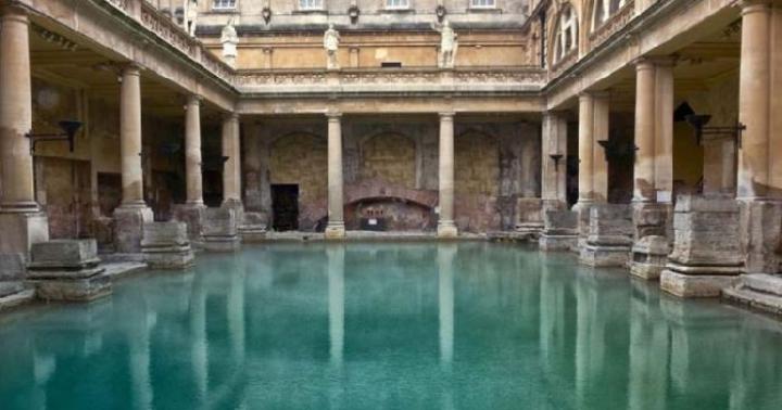
Bay, Lake Ladoga and rocks (photo by Oleg Semenenko)
Shores of Lake Ladoga. From the mouth of the Vuoksa to the source of the Neva, the coast consists of clay and loamy sediments, bordered by sandy soil, with numerous boulders. Up to the mouth of Taipala, the coast is still quite elevated, but further to the south there is a low-lying desert coast, partly sandy and partly covered with thick grass. The southern shore of the lake, between the source of the Neva and the mouth of the Svir, is low-lying, almost treeless and consists of clayey and swampy soil; formed by sediment from rivers flowing into the lake, it is bounded from the south by an elevated ridge of limestones of the Silurian system, which, in all likelihood, was once the shore of Lake Ladoga. Currently, they are located at a distance of 3 to 30 kilometers from it, and only near the mouth of the Svir the limestones with their rocky cliffs cut like a wedge into the shore of the lake, towards Cape Storozhensky, forming the outskirts of a peninsula that protrudes far into the lake.
Eastern coast, from the mouth of the Svir to lake. Karkun-lamba, at first low-lying and partly swampy, gradually rises and consists of clayey and loamy soil, which on the very coastline turns into purely sandy. The coastal area of the northwestern part of the lake is in complete contrast to the southeastern part. Here the shores and those adjacent to them are elevated, rocky and consist mainly of granite, partly gneiss, syenite and other crystalline rocks, as well as various types of marble.
From Kexholm to the north and further east to Impilax, the granite gradually changes from light gray and coarse-grained to bluish-gray and fine-grained, very strong and hard, then, to Pitkerando, it turns reddish, but south of Pitkerando the granite completely disappears from the surface land, and the soil is sandy-clayey, filled with boulders of various types, and granite is found only in low-lying capes protruding into the lake, consisting of fine-grained red granite.
Islands in their composition and height they correspond to the shore near which they are located. Almost all the islands in the northern part of the lake are elevated, consisting mainly of granite and hard rock, while the islands in the southern part are low-lying, partly marshy and surrounded by shallows and reefs. Thanks to the many islands and significant ruggedness of the shores, the northern part of the lake is very rich in bays and bays sheltered from the winds, which represent very comfortable places for a quiet anchorage of ships, but in the southern part of the lake there are almost no such places with almost everything, as a result of which ships here, in strong winds, are forced to settle in open lake, mainly in the open and dangerous Koshkinsky roadstead.
Of the islands in the northern part of the lake, near the shores, the most remarkable are: the island of Kuko-sari, lying at the mouth of the Vuoksi River. In the Kronober Bay: Kilpodan, Korpan and Teposari, the last two of which form the entrance to the bay, which is a vast bay, completely calm for ships. The island of Sarolin, which makes up the left shore of Yakimvar Bay, is 12 km away. jutting out into the mainland and representing a safe bay with all sorts of conditions.
Of the islands in the middle of the northern part of the lake, the following stand out: the Valaam group, consisting of 40 islands that stretch parallel, at a distance of about 20 km. from the extreme islands of the northern skerries. The main and largest of this group is the island of Valaam (26.2 km2), which has a very irregular shape, but with the closely adjacent islands of Skitsky, Predtechensky and Nikonovsky, it appears in the form of an equilateral triangle. In its northwestern part, on a rock, the Valaam-Preobrazhensky Monastery is located, in the depths of the bay, with a convenient pier. To the east of Valaam stretch the islands: Baiovye and Krestovye. To the southwest of the island: Gange-pa with a lighthouse, Muarka, Yalaya and Rahma-sari, lying almost on the same parallel. To the south are the islands: Suri Verko-sari and Voschaty or Vasiya-sari. To the south of this last island lies Konevets (6.5 km2), on which the Konevsky-Rozhdestvensky Monastery is located.

Lake Ladoga (photo by Dmitry Savin)
Depth Lake Ladoga is generally quite significant; distributed unevenly, depending on the height of the banks: the steeper and more elevated the shores adjacent to the water's edge, the greater the depth and vice versa. From the southern low-lying shore, the depth, starting from half a meter, slowly and gradually increases; having passed the reefs and shoals protruding from this shore, it begins to quickly increase, so that in the middle of the lake it is from 60 to 110 m, further to the north it increases to 140, and in some places reaches 200 meters. Thus, the Ladoga bottom has a very significant slope from south to north, and it consists of a number of more or less irregular ledges, on which in some places there are significant mounds and hills, in places there are depressions and basins. Thus, between the lines of equal depths of 60 and 80 m, there are bottom elevations at which the depth is only 32 m, and in the northwestern part of the lake, between the lines of equal depths of 10 and 140 m, there are depths of 200 or more m.
Water level and currents. The water level of Lake Ladoga is subject to constant fluctuations, depending on the totality of all meteorological circumstances in the entire basin of the lake, as a result of which the height of lake water not only in different years, but also at different times of the same year can be very different. Since time immemorial, the existing belief about the seven-year periodicity of changes in the lake water level, according to which the lake water horizon constantly seems to rise for 7 years, and constantly decreases over the next 7 years, was completely refuted by 14-year observations, which were produced on the island of Valaam and of which there was no correctness in changing the position of the water level.
Opening and freezing. First of all, shallow water is covered with thin ice. South part lakes, usually at the beginning of November, sometimes at the end of October, at a temperature of about 5 degrees Celsius. This thin ice or lard is carried by the current into the Neva, where the autumn ice drift begins and does not last long. In the lake itself, with increasing frosts, the entire southern part of the lake is covered with ice, both at the very shore and in the space between the reefs and shoals protruding from it. Further, to the north of the parallel of the Sukhsky lighthouse, under the influence of winds that easily break up the formed ice, the lake does not freeze for a long time, and at great depths in the northern part it freezes only in December, often in January, in other years the middle of the lake remains unfrozen all winter .
In general, the lake is covered with solid ice only in the most severe winters; during ordinary frosts, only the outskirts, 20-30 kilometers from the shores, are covered with ice. Determining whether the middle of the lake is frozen or not seems to be quite difficult, due to the distance of the middle of the lake from the shore. Fishermen who carry out ice seine fishing determine this with great accuracy by the current in the ice holes: if in the ice holes there is a current corresponding to the direction of the wind, then the middle of the lake remains unfrozen, but the absence of a current shows that the entire lake is covered with solid ice.
The opening of Lake Ladoga, like freezing, also begins at the southern shore of the lake, usually at the end of March - the first half of April, simultaneously with the opening of southern tributaries and warm water, which has a direct impact on the opening of the Neva, which always begins from the source, near Shlisselburg , and there are two ice drifts on it: the river itself, which does not last long, and the very long Ladoga ice drift, which almost never passes at once.
Lake Ladoga is located on the territory of Karelia and the Leningrad region and is considered the largest freshwater lake in Europe. It stretches from south to north for 219 km, the greatest width is 138 km. The depth varies unevenly: in the northern part it ranges from 70 to 230 m, in the southern part - from 20 to 70 m.
The famous Lake Ladoga, on the ice of which the Road of Life ran during the siege of Leningrad, today - unique monument Karelian nature, annually attracting thousands of tourists. Its shores and islands are amazingly picturesque. The most famous are, of course, Valaam and Konevets, where ancient unique monasteries are located. But every island, every rocky cape on Ladoga is something special.
On the shores of the lake are located Priozersk, Novaya Ladoga, Shlisselburg in the Leningrad region; Sortavala, Pitkyaranta, Olonets, Lakhdenpokhya - in Karelia. 32 rivers flow into the reservoir, but only one flows out - the Neva.
Every year, since 1997, the Ladoga Trophy takes place on the shores of the lake: an off-road rally along the perimeter, the route of which is approximately 1,200 km.
How to get to Lake Ladoga
First of all, you need to decide which side of the lake to “drop anchor” on. You can reach the north and east from Petrozavodsk, and the north, east, south and west from St. Petersburg.
From St. Petersburg, the most types of transport go to Priozersk. Every half hour from Northern bus station and several times a day from the Parnas metro station - buses from the Piteravto company (office site), travel time is about 2.5 hours; daily trains of the North-Western Suburban Passenger Company (office website) from Finlyandsky Station take you to your destination in just 2 hours (a regular train takes almost 3). By car, getting to Priozersk is also about 2 hours from Piskarevsky Prospekt along the A-118 and A-121 highways (aka Priozerskoye Highway).
There is also a railway station in the village of Lake Ladoga; it takes just under 1.5 hours to reach it from St. Petersburg from Finlyandsky Station by daily train SZPPK, and by car - a little over an hour along the Road of Life highway.
To the “Karelian part” of the lake, to Sortavala, from the Ladozhsky station in St. Petersburg, it takes more than 5 hours to travel by train St. Petersburg - Kostomuksha from Russian Railways/FPK (office site). By bus company " Passenger Transportation", which runs several times a day from the Northern Bus Station, - 5-6 hours (all flights traveling in this direction make a stop in another picturesque place - Lakhdenpokhya).
From St. Petersburg, cruise ships of the Vodokhod operator go through the island (office site): the voyage takes a week, starting from the St. Petersburg pier “Utkina Zavod”. From Priozersk from the Valaam pier the motor ship “Valaam” will deliver to the island of the same name in 3.5 hours, “Meteor” - in 1 hour 15 minutes, departure daily. From Moscow, from the North river station, multi-day tours with a visit to Valaam invites you to take “Mosturflot” (office site).
Bicycle rentals are available in Priozersk, Shlisselburg, Novaya Ladoga, and Lahdenpokhya. A bike can be found through a private classifieds website, but most often rental is included in the list of services of large tourist centers.
Ladoga lake
Lake Ladoga Hotels
Dozens of hotels, guest houses, family hotels and even peasant estates. They are ready to accept both single tourists and entire groups - by prior arrangement.
Price per night - from 1500 RUB for accommodation in a budget double room in the Starhouse mini-hotel in Shlisselburg on the street. Chekalova, 14 to 25,000 RUB for a cottage for 6 people in the “Ladoga Estate” on the Karelian coast of Lake Ladoga (Ozernaya St., 1, Niemelyanhovi village, not far from Sortavala). The house has its own sauna, fully equipped kitchen, three double bedrooms with private bathrooms and a barbecue area.
Price single room in a hotel or guest house- from 5000 RUB per day. However, numerous visitors are happy to save on this expense item and settle on the shores of Ladoga as savages, in tents.
What to bring
The St. Petersburg shore of Ladoga is not rich in exclusive gifts: a typical set of magnets, mugs, postcards, wood and birch bark items. On the Karelian coast of the lake, the assortment of souvenirs is more interesting.
Karelia is home to shungite deposits. Beads, bracelets made from this mineral and even cosmetics containing it can be found in Sortavala, Lakhdenpokhya, Pitkyaranta and other settlements in the Karelian part of Ladoga. The famous tinctures “Karelian Balsam” and “Karelian Collection” are also sold there.
Another noteworthy rarity is products made from Karelian birch: spoons, boxes, plates. An excellent addition to them would be tablecloths and napkins with Zaonezh embroidery.
It is impossible to leave Lake Ladoga without “tasty souvenirs” - raw and smoked fish, berries, mushrooms, herbs. Some will be lucky enough to collect and catch it on their own, while others will have a direct route to the markets.
From Ladoga churches and monasteries, especially from Valaam, guests bring icons, candles, and crosses. The island is also famous for its gingerbread.
Cuisine and restaurants of Lake Ladoga
There are a lot of catering establishments in the villages and towns of Lake Ladoga, of course, but you won’t die of hunger either. In restaurants and cafes, Russian, Caucasian and European cuisines are held in high esteem, there are pizzerias, and there are places to try sushi and rolls.
Main ingredient of most local dishes- fish, most often pike perch. It is used to make dumplings, cutlets, soups and snacks. Fish is also added to “wickets” - signature Karelian pies made from rye dough. They are also made with mushrooms and berries, of which there is an abundance in the local forests.
Cafes and restaurants are located mainly in hotels, camp sites, guest houses and near main attractions. The interior and service sometimes cause criticism, but the skill of the chefs, on the contrary, deserves praise.
The price range is small: in Sortavala, and in Shlisselburg, and somewhere in Vidlitsa, breakfast for two will cost 700 RUB, lunch - 1200 RUB, and dinner with alcohol will cost about 2500 RUB.
Entertainment and attractions
There is no point in listing all the museums located on the shores of the lake - their names are legion, the exhibitions are often similar: the history of the city, folk crafts, paintings by local artists. The museum of the private collection of Kronid Gogolev in Sortavala (Komsomolskaya St., 6) stands apart. Its founder is a skilled wood carver. In his own art space, he exhibits not only his own works, but also the creations of other Sortavala masters. Another almost pilgrimage place is the Road of Life Museum in the village of Lake Ladoga.
Among the museum's exhibits are steamships, an airplane, and military weapons that stand right in the open air. In the indoor halls there is an exhibition of cars that plied along the Road of Life, exhibitions dedicated to the Great Patriotic War and the famous highway. 5 km from the museum, to the south of the lake, there is the “Broken Ring” memorial.
One of the main “miracles” of Ladoga is the island of Valaam and the Spaso-Preobrazhensky Monastery standing on it. People come here to feel a special peace and tranquility, to pray at the myrrh-streaming icon of the Mother of God painted by Hieromonk Alypius, to admire the landscapes that inspired Kuindzhi, Shishkin, and Roerich.
You can go to Valaam and back by boat from Priozersk, where the Kexholm fortress (Korela fortress) built in the 13th century stands: a small building is surprisingly harmoniously integrated into the landscape. Near Priozersk there is Konevets Island. A whole ensemble of religious buildings, crowned by the Konevsky Nativity of the Mother of God Monastery, brought him fame. Within its walls is displayed the miraculous icon of the Mother of God, brought from Athos by the founder of the monastery, Arseny Konevsky.
The south of Ladoga is Shlisselburg with the not so impregnable fortress Oreshek, built by the grandson of Alexander Nevsky. With her observation deck The views of the lake and the Neva flowing from it are especially good. East of Shlisselburg stands Novaya Ladoga, which boasts a group of wooden and stone churches and cathedrals and memorial sites associated with the Road of Life.
Fishing on Lake Ladoga
Lake Ladoga is home to 53 species of fish: Ladoga slingshot, salmon, trout, whitefish, vendace, smelt, bream, raw fish, bluefish, silver bream, rudd, asp, catfish, pike perch, roach, perch, pike, burbot and others. Human impact on the reservoir reduces the number of valuable fish - salmon, trout, palia, lake and river whitefish and others, and the Atlantic sturgeon and Volkhov whitefish are listed in the Red Book of Russia.
Ladoga lake is the largest freshwater lake on the European continent. For Russia, this lake has great industrial, environmental and historical significance. Another name option - Ladoga.
If you look at the map, you can see that the shores of Lake Ladoga belong to two Russian regions: the Republic of Karelia and the Leningrad Region. That is, it is located in the European part of the country.
On the north side Ladoga The shores are high, rocky, their relief is quite rugged, which explains the presence of a large number of peninsulas, bays, and small islands. From the south of Ladoga, the lake is surrounded by low, gentle, more even shores. The largest bays are also located here: Volkhovskaya, Svirskaya, Shlisselburgskaya bays. The eastern coast is also not particularly rugged; there are sandy beaches. In the west the coastline is almost flat. Mixed forests and bushes grow here; there are many large stones near the water on land, which also cover the bottom under water for quite a distance.
They bring their waters into Ladoga lake There are 35 rivers, but only one flows out. The largest river bringing water is the Svir. What river flows from Lake Ladoga? This is the famous Neva, on which the second largest city stands Russian Federation- Saint Petersburg. Some rivers bring water into Ladoga from other lakes, such as Onega or Ilmen.
There are a large number of islands on the lake - at least five hundred. The largest islands Ladoga together they constitute the Valaam archipelago. The largest single island is Riekkalansari. Also a large island is Konevets, where a famous monastery was built, just like on Valaam.

Dimensions, extent and depth of Ladoga
The depth of Lake Ladoga is uneven throughout its territory - it increases from south to north. The maximum depth of Lake Ladoga is 233 m. The average figure is much lower - 50 m. In the north of Lake Ladoga its depth varies from 70 to 230 m, and in the south - from 20 to 70.
The area of Ladoga is 17.87 thousand square meters. km. The volume of water in Lake Ladoga is 838 cubic meters. km. The length from north to south of the lake is 219 km, in the wide place Ladoga stretches for 125 km.
Climatic features of the area
Lake Ladoga has a generally temperate climate. In the geographical area where Lake Ladoga is located, not much sunlight penetrates throughout the year. Therefore, the evaporation of water from Ladoga occurs quite slowly. Most days of the year it is cloudy and cloudy here.
Between the end of May and mid-July Lake Ladoga You can observe the famous phenomenon of “white nights”, when at night the sun practically does not set beyond the horizon.
Throughout the year, western as well as southwestern winds blow on Ladoga. In winter, Lake Ladoga freezes until the end of spring, but is completely covered with ice only in the coldest winters. This long period of glaciation affects water temperatures throughout the rest of the year. average temperature The water here is low: at depth it stays at 4°C, and on the surface Lake Ladoga Depending on the time of year and site, it can range from 2 °C to 24 °C. The water is not as clear as on Lake Baikal, but this may be due to the fact that many species of algae and small plankton live in it, and constant storms agitate its surface, churning up the foam.

History of Lake Ladoga
Lake Ladoga was formed as a result of the melting of glaciers and over several thousand years its outlines formed and changed.
Until the 13th century, the lake was called Nevo, which apparently was directly related to the name of the Neva River. Then it was called Lake Ladoga, taking the name from the city of Ladoga located here. Many objects in this area have names originating from the Karelian language. But the most likely explanation for the name “Ladoga” is considered to be Finnish versions - from ancient words denoting water or the concept of “lower”, which are consonant with Ladoga. The name Nevo also has Finnish roots and can mean “swamp”. It is quite possible that in those days the lake gave reason to call itself that; there are many traces of swamps in this area.
Along Lake Ladoga, starting from the 9th century, the water part of the route “From the Varangians to the Greeks” passed from Scandinavia through the territory of Europe to the country of Byzantium. In the 8th century, the city of Ladoga was built here, and soon other cities and fortresses began to appear here. At the end of the 14th century, the famous Valaam Monastery was founded on the islands of the same name; its buildings are still a pearl of wooden architecture.
For many years there was a war with the Swedish state for part of the lands lying on the shore of the lake. Peter I nevertheless managed to ensure that Ladoga became Russian. In 1721, according to an agreement with the Swedes concluded after the war, the entire coast of Lake Ladoga went to Russia.
To make navigation on Ladoga more accessible, a canal was built here.
During the difficult war years from 1939 to 1944. The Ladoga flotilla was based in Lake Ladoga and fought in its waters. In 1941–1944 more than half of the coast of Lake Ladoga was occupied by enemy troops. From September 1941 to March 1943, the “Road of Life” passed along the ice of Ladoga - the only route along which provisions and necessary things could be delivered to besieged Leningrad. The evacuation of people was also organized along it; in total, about 1.3 million people took advantage of the evacuation.
Thus, Ladoga is a lake that has special significance for Russian history.
Ecology of Lake Ladoga
Basically, the waters of Ladoga are very clean, but there are problem areas. This is largely due to the development of industrial zones near Lake Ladoga, as well as with the consequences of World War II. During the war, radioactive weapons were tested in this area and on some islands. In particular, the reaction of animals to the consequences of its use was studied. In addition, many sunken military ships and aircraft with ammunition create an unfavorable radiation background.
The number of contaminated places is growing. On the shores of Ladoga there are approximately 600 industrial enterprises that pollute the air, dump industrial waste into the Ladoga River and others, which then bring them into the lake. By the way, the correct answer to the question – Ladoga is a river or a lake is that it is both. There is a river and also a city with the same name. At the same time, historians claim that first the river received its name, then the city, and only after that Lake Nevo was renamed.
Pollution of Lake Ladoga today is considered to be at a moderate level. In some places, radiation standards are exceeded - where supplies were previously tested, as well as those closest to nuclear and other industrial enterprises.

Nature and fauna of Lake Ladoga
The nature of Lake Ladoga is very beautiful; this place is a very famous place for tourists and travelers to relax and go hiking. Majestic rocks, mountains, pine forests - all this creates a unique image of this place. Rare plants and animals are found in various nature reserves of Ladoga. Despite the difficult climate, even some southern plant species grow here, and in the north - typical representatives of the tundra (saxifrage). The forests on Lake Ladoga are not only coniferous, but also broad-leaved - with maples and elms.
Fauna Lake Ladoga includes representatives of the taiga: foxes, wolves, hares, bears, etc. There is also an original animal that is found only here - the Ladoga seal. The animal, which is more typical for the seas, feels great in the fresh water of Ladoga.
Lake Ladoga is home to approximately 50 species of fish. The most popular among fishermen and industrialists are smelt and pike perch.
Holidays on Lake Ladoga
Around Lake Ladoga you can find places to relax for every taste and for any purpose: recreational, hiking, entertainment. You can often meet fishing enthusiasts here. Everything you need for such activities is located at the recreation centers, including almost every one of them with instructors who will teach you the intricacies of this or that type of pastime.
People love diving here because of the large number of finds that can be found on the bottom and simply beautiful underwater views. You can also choose relaxing holiday on the beach when weather conditions permit.
Excursions to natural and historical attractions of Ladoga are also organized, for example, buildings remaining after the war, old fortresses or mountain peaks.
Attractions on Lake Ladoga
The sights of Lake Ladoga are worth talking about separately. Here is, for example, an interesting beautiful views almost untouched nature of the Nizhnesvirsky reserve. It is home to a huge number of bird species and many animals.
The island of Valaam on Ladoga with the monastery of the same name is of historical, cultural and architectural value. Not to mention the fact that pilgrims come here from all over Russia and beyond.
The memorial complex dedicated to the Road of Life tells the story of the heroic feat of people who, in the most dangerous conditions, traveled on the ice of Lake Ladoga, risking falling through the ice or being shot at by the enemy. Still, they did this in order to save the lives of city residents who survived the terrible siege.
Also of historical and cultural interest on Lake Ladoga are the cities of Shlisselburg, founded by Peter I, with the Oreshek fortress, and Novaya Ladoga.
Lake Ladoga in works of art
Ladoga is a lake that is reflected in folk legends and examples of folk art of the various peoples who lived here. These are mainly Karelian and Russian epics.
The famous Karelian folk composition "Kalevala", which was once passed down from mouth to mouth, describes the events that took place in the north of Lake Ladoga.
In his youth, Constantine Roerich made an expedition along the rivers flowing into Lake Ladoga and to the lake itself. From 1916, he lived in this area for two years and created several paintings, sketches, poems and fairy tales here.
Thanks to its amazing nature, Lake Ladoga primarily inspired painters who were delighted with the local colors and landscapes. Many wrote about the Valaam Monastery, as its buildings looked especially impressive and mysterious against the backdrop of majestic nature. The lake with the sonorous name Ladoga also evokes fairy-tale scenes. Such masters of painting as F.A. Vasiliev, A.I. Kuindzhi, N.K. Roerich, I.I. Shishkin worked here.

Industry on the lake
The lake is used for the passage of ships whose routes along it are sections of the Volga-Baltic Route and the White Sea-Baltic Canal. The weather on the lake is very changeable and ships are often threatened by storms and high waves, so shipping is periodically suspended. Once upon a time there was even a widespread expression that if a sailor has not sailed on Ladoga, then he is not yet a real sailor. Such a phenomenon as complete calm is quite rare on this lake.
Various industrial cargo and construction materials are transported across Lake Ladoga. They also go here passenger ships And cruise ships, for the most part these are tourist routes.
About 10 species of fish, such as smelt, pike perch, and whitefish, are caught here on an industrial scale. Not far from the lake there are industrial enterprises: a paper and pulp plant, aluminum, oil and chemical production, etc.
Mysteries and secrets that the bottom of Lake Ladoga keeps
At the bottom of the lake there are many interesting things for researchers and lovers of various mysteries and secrets of things. Of course, the greatest success is considered to be to find something very ancient, dating back to the Vikings. But the most common artifacts found are those left over from the Second World War. They are better preserved and easier to find. For example, the attractions of that time that attracted extreme tourists and divers included the so-called “Death Bay,” the bottom of which was practically covered with shell casings, since a fierce battle took place here in 1941.
Amateur divers find sunken ships and wartime aircraft. Unlike sea water, fresh water does not destroy and spoil sunken things so much, which is why the finds of Lake Ladoga are so attractive.
Lake Ladoga lies in the northwestern part of the Russian Plain. It lies between parallels 59°51` and 61°46` N. w. and meridians 29°48 and 32°58` E. d. Administratively, this is the territory of two regions of our Fatherland - the Leningrad Region and the Republic of Karelia. It is considered the largest reserve of lake (and at the same time fresh) moisture in Europe and the second largest water mirror in Russia. Tourism object.
How the lake was formed
Lake Ladoga was born during the last (Valdai) glaciation, which ended 12,000 years ago. The flow of water from the melting glacier and the simultaneous change in the level of the World Ocean led to the appearance of a coastline of modern outlines (before this process, part of the Ladoga water was in the sea, and the other half was the territory of its raised bottom). On this moment area of this water mirror(that is, the space that does not include pieces of sushi) is 17,870 square kilometers(this is the second position in the list of Russian lakes after Baikal). The volume of the Nevo water mass (as the hydrological object was previously called) is 838 cubic meters, the size of the waste basin is 258,600 square kilometers. It became so thanks to 40 rivers and streams. The Neva “pours out” lake water. River and stream feeding regime. An amazing phenomenon is the depth of Lake Ladoga. But the fact is that in some northern fragments of the water area the parameter is 230 meters.
Shores of Lake Ladoga

The depth of Lake Ladoga is not as remarkable as its greatest length. The distance between the Ladoga points that are farthest from each other is 219 kilometers. On normal (medium speed) motor boat It takes 3.5 hours to cross this surface of water. The greatest width is also impressive. It is identical to 125 kilometers, narrowing significantly in the north. But that’s where the longest bays are. It is from the north that we will begin to explore the shores of Lake Ladoga, moving clockwise. Our journey begins from the Karelian village of Kiryavalahti - the geographical center of the Sortavala region of the republic. Its water edge is the most northern point the bizarre circumference of the Ladoga reservoir, as well as the base of the Kiryavalahti Bay. The A-121 highway passes here literally 15 meters from the water's edge, very flat and overgrown with black alder, pine and birch. Moving further along the marina, we find ourselves in the settlement of the same name, surrounded by dense taiga. There are no capes here; the fishing platforms stand exactly between large stones. The depth increases suspiciously quickly. The exit of the bay to the main body of water is marked by a panorama of first two small islands, and to the southeast - an archipelago of 11 pieces of land, among which there are some impressive ones (they will be discussed in another chapter). From the village of Hiidenselga, the observer already sees the giants of the island world, and then the main water area of Lake Ladoga appears before him. Here the depth gauge already shows 70 meters or more. In this place (the mouth of the Jänisjoka) the Balovina is widely flooded in the spring. Our further movement occurs along the edge, outlined by approximately 1-2-meter stone pits. We go further south and realize that we find ourselves on a patch that is most strongly curved by capes. From here, making your way among the densest thickets, numerous lake bays begin to feed dozens of streams, and the harbor of Impilahti already looks very much like a classic fjord. Further travel to the southeast will make you see many more of these stream branches, leading inland 6-8 kilometers. During the season, the entire Impilahti Bay is filled with tents, rubber boats are visible everywhere... Continuing the water trip along the shores of the Pityakaranta urban settlement, the traveler finds himself in the very regional center.

Pieces of coastal land are steep and rocky; passengers of the ship will first be greeted by the island of Pusunsaari, partially occupied by an industrial zone. The adventure continues with the exploration of Uuksu, Salmi, Miinaloi and two of the largest islands - Mantsinsaarai and Lunkulnsaari. Opposite them, at a decent distance, the island of Valaam appears through binoculars. South of the coast Lake Ladoga reveals to us the same swampy and pine-covered Olonets region of Karelian autonomy. At the border capes, the Vidlitsa River flows into Ladoga, and 25 kilometers from here we are already enjoying the riviera of the village of Ilyinsky (the mouth of the Olonka River). The shore goes into the water at an angle, but it is already sandy! The southeastern shores of Lake Ladoga are the long Svirskaya Bay (lower reaches of the Svir) and the cape with the village of Storozhno. Here the “baths” end, the low marshy banks, densely covered with cattails, reeds and sedges, “take the initiative”. On the ascents there are dense grasses. We see the same thing in the settlement of Syasstroy, next to which is the confluence point of the Syasi. It feeds the Svirsky Canal, which follows the coastal contours. Novaya Ladoga, a huge protrusion of land and Petrokrepost Bay are the lowest landmarks on the map. There is also thick grass and swamps here, and the water is much shallower. The area is memorable for the “finish line” of the Neva, the town of Shlisselburg and the fortress island. The beach for the common people begins to the north of the Neva Arm – it’s slimy and earthy. Sometimes there are pebbles again.
And then swimmers turn north again. In the southwest there are majestic rock walls, along the entire western coast there are many ruined Finnish farms and wide water meadows. To the north, a holiday on Ladoga will not allow you to let go of your camera. For example, beyond Priozersk there is a section of water area that has been dubbed the “country of islands.” On most skerries and islands there are no problems with firewood; in the west the forest is closest to the water. Cape Kurkiiemi is the first location where the Ladoga rocks appear in all their grandeur. From here the bank is very high. Murolahti Bay is a typical fjord. We see such landscapes as far as the villages and islands of the Sortavala region, on the territory of which the coast is rocky, but already significantly lowered. It remains to add that in addition to Priozersk, the western half of the lake shore includes Landepohya and the large “Sortavala” islands. The places are adored by tourists, as here picnic lovers find gently sloping shores, convenient for both bivouac and fishing. The landscapes here are the most idyllic. And quiet! As a result, we can say that the entire eastern half of the water area and the southern end, the low-lying swampy shore, consists of clay and loamy sediments, and in some places even sand. The western half (20 kilometers from the mouth of the Neva), on the contrary, is a high stone pit. You will learn why this happened in the text of the next section.
Relief of the bottom of Lake Ladoga

Let us repeat that the depth of Lake Ladoga is uneven, varying from 20 meters (in the area of the eastern fjords) to 230 meters (the northern half of the water area, a little closer to the west). The reason for this is the origin of the surface itself, which was later covered by lake waters. Part of it was originally marine, and part of it was the Baltic crystalline shield. That is, a rise formed by rocks that emerged from a crack in the East European Platform. Here is the most deep depression. Then the shelf of the already mentioned platform gradually gains height. From the northern banks its slope is several times steeper than from the southern ones. After all, between the two geological formations there was water in prehistoric times. We are talking about the deepest part of the lake basin. The northwestern corner and the entire west are composed of the oldest rock massifs of the Baltic Shield. The remaining water spaces changed their shape thousands of times due to the increase in the volume of Quaternary sediments and ongoing tectonic activity. 4 thousand years ago the bed of the Neva appeared. The current contours of the lake were born 2.5 thousand years ago. The flattest and softest bottom of Lake Ladoga is located in the transgressive south and southeast. Here the water warms up faster. The Ladoga Islands are just the tip of underwater concepts with complex terrain. This is precisely why in the center of the Western Riviera there are so many skerries and archipelagos with tiny pieces of land. And just between them there are dangerous pools.
Islands of Lake Ladoga

Where the bottom of Lake Ladoga is deepest, we see Valaam, Putsaari, and an archipelago of 6 insignificant islands, which were not even given a name (it borders the deepest zone from the south). It's a little cooler here, there are a lot of stones. From the east, a chain of smaller patches of land adjoins the famous island tract. On the remaining fragments of its northern half, Lake Ladoga has the above-mentioned “country of islands” (Western Archipelago, Ladoga Skerries). This is the most difficult route in “our” water area, replete with skerries of a strongly protruding peninsula, fjords and inter-island straits with whirlpools. Those are formed due to contradictory currents and temperature contrasts. To the west of this group is the deepest depression, as is to the southwest (behind which lies the Treeless and Humps archipelago). For this reason, the water in these harbors is almost always icy. The shore is replete with, if not the highest, but still significant stone holes. The largest pieces of land are Sorolonsaari, Heposorolonsaari, Kuhka, Rahmansaari, Heinäsenmaa, Verkkosaari, Kärpänsaari, Kontiosaari (Bear), Karpisari, Kilpola and Montasaari. The princess islands, as well as the Tervu and Ihojanverkulä peninsulas, have barely noticeable isthmuses connecting them to the mainland. To the north of Valaam (in a zone of slightly smaller, but still significant depths) we will find the largest isolated objects of the lake - about. Riekkapansaari and Fr. Tulolansaari. Neighboring them in the southwest are Orjatsaari and Sammatsaari. They end with a group called Mayasaaret. There is also a “trifle” between all these objects. On the eastern side, northern Lake Ladoga has giants of the 2nd position - Mantsinsaari and Lunkulonsaari. But to the northwest of them there are many more small islands at the exit of the most elongated fjords. The islands of the east are quite close to the coast, have convenient shores and are well developed. One even has an industrial zone.
In its southern half, Lake Ladoga is no longer so saturated with archipelagos. In the Leningrad region we visit the marshy island of Ptinov, then (in Petrokrepost Bay) the Zelentsy Islands, then the Karedzh Spit and the island of the same name behind it, as well as Fort Oreshek (at the mouth of the Neva). Finally, in the center of the western side, the passengers of the ship will only be able to see Konevets. But it is still a little closer to the northern half.
There are 77 islands on the entire Ladoga mirror, some of which are groups of islands.
Flora and fauna

The biocenosis of the northern and eastern shores of the described water body belongs to the middle taiga zone, and the southern and western riviera belongs to its southern variety. That is, the vegetation in the first case is spruce-blueberry forests (on thick mosses), and in the second case – pine trees, black alder, birch and fir. Moreover, all this stands on a very rich undergrowth. The water itself is home to 120 higher plants, among which a variety of reeds (mostly cattails) dominate. Accordingly, in the Karelian part of the water area, visitors will see seals and otters. In Leningradskaya Ladoga there are the same animals, but it is also an area of large bird migration (256 species of birds rest here along the way). Among them, in the swamps and fields, ospreys, cranes, white-tailed eagle and the ubiquitous curlew and falcon were found. A beaver approaches lake shores (at river mouths). The coastal forests are permanently inhabited by the eagle owl, short-eared owl and great gray owl.
In addition to planktonic animals and coastal semi-aquatic inhabitants (crayfish), the local water contains a lot of all kinds of ichthyofauna. The fish of Lake Ladoga are trout, salmon, whitefish, palia, vendace, bream, smelt, silver bream, blue bream, asp, catfish, burbot. Of course, there is also plenty of more prosaic waterfowl here - pike, perch, roach and pike perch.
Sights of Lake Ladoga
Leisure in the designated recreation usually comes down to picnics with overnight stays, as well as any kind of fishing. But there are 7 objects where all this is combined with cultural, historical and extreme tourism directions. We will tell you about each of them.
Western Archipelago (Ladoga Skerries)

Such a vacation on Lake Ladoga is part of a yacht or boat mini-cruise (whoever has enough money for what). Typically, “Secrets of Ladoga Skerries” tours start either from the Priozersk pier or from the Sortavala pier. By water you can come here through Cape Taruniemi (through the yacht marina of the Dacha Wintera park hotel). They rent boats there. But simple people choose the land route. People reach the skerries by land from Shlisselburg and the Northern capital. Along the St. Petersburg – Helsinki highway (A-121). You should turn towards the lake at the exit to Kurkieki. From Kurkijeki itself there is an “asphalt road” to the Tervu Peninsula – the center of the skerries. It has a western part, as if cut off by a strait. From the plane you would never guess that it is also part of the peninsula. It is so cut up by fjords and adjacent to so many islands that different fragments of the Mykrimyksensaari tract are also perceived as islands. The isthmus is barely noticeable, but it exists – in the area of the northern fjord. On the way to Terv there is an exit onto a very inconspicuous road leading to the Vyatikkya farm. From here there are also safe fairways into the fjord system. The watermen say it’s very beautiful here. Part of the specified labyrinth space (namely 600 of its islands and part big land) has the status national park. Therefore, follow the signs when trying to drive your car too close to the water. The fact is that there are water protection zones. It is better to drag a rubber boat 200 meters than to pay a fine. There are plenty of places for tent camps here - the territory is almost uninhabited, and there are no sandbanks here (noisy "mattress areas" that produce tons of garbage do not come here). At the same time, the water is crystal clear, and the pine trees along the banks are somehow too fabulously curved. It remains to tell about Terva itself - the “capital” of the peninsula, the bay of the same name, and the entire Ladoga Skerries reserve. These are 12 wooden houses, as well as a new pier and recreation center “Tervu Village”. And there is everything for fishing, water and diving leisure.
Sortavala city

On far north Lake Ladoga washes the lands of the Sortavala region of Karelia. The regional center itself is separated from the main bay of the water area largest island lakes – Riekkalansaari. The toponym translates as “Greek island”. This simply means an indication of the local Orthodox church - the oldest in the land of pagan Karelians. The island has its own bay, inside which there are also islands, several small reservoirs and 8 Sortavala rural-type microdistricts. They look very colorful in photographs. A bridge leads here from the mainland (from the central city districts). The strait between the island and the town is recognized as a lake. It is called Läppäjärvi. But in the center of Sortavala, tourists will find the St. Nicholas Church, the Town Hall in a pseudo-Gothic style and the spacious lakes Airanne and Tukhkolampi. There are equipped parks around the first two attractions. The embankment of inland lakes is partly a recreation area. Vakkosalmi Park contains entertainment for all ages. There is an ethnographic and local history museum of the Northern Ladoga region, telling about the history of this region. Among the closest recreational areas is the “House of Composers” estate in Kirjavalahti (the locality has already been mentioned above). Guest establishment, near the road.
Reserve "Valaam"

The waters of Lake Ladoga are home to five famous water routes, the most popular of which is associated with a visit to the complex indicated in the title. People come here on different ships from Sortavala, Shlisselburg and Priozersk (in which even one pier is called Valaamskaya). The main point for the outing is the monastery of the same name. Behind it come Mount Eleon (the best local “view” of the center of the island), the monastery of All Saints (an authentic religious ensemble), the no less colorful Resurrection Monastery, as well as the exquisite and curious Resurrection Chapel.
Resort Priozersk

Fishing on Lake Ladoga becomes far from the main form of recreation if you find yourself in the west of the “northern” water area. Although inconvenient, there is a seaside equipped for swimming, yacht pontoons that lure you into adventure, kiosks of tour operators, cafes and entertainment, trips to the Korela fortress, as well as an excursion to the Protestant church, once built by the Swedes. This is the main brand of an agglomeration popular with tourists. It is also worth emphasizing the excitement surrounding the souvenir shops and the quaint Priozersk courtyard of the Valaam Monastery. And it includes temples of 3 religions, as well as the Church of All Saints, which has features that unite all three of these buildings. It’s also not far from Priozersk to the picturesque lakes (that’s why the town has its name). Along the way there is the Vuoksi embankment and a couple of restored noble estates.
Fortress Oreshek

The most famous historical holiday on Ladoga is a visit to the island citadel Oreshek (Swedish name Nöteborg). The fortification, built by the Novgorodians back in the 14th century, was taken from them first by the Moscow state, and then by the Kingdom of Sweden. Recaptured from its last owners in 1702. The troops of Peter the Great. In plan, the fortification has the shape of an irregular triangle. There are 5 towers along the perimeter. The inner citadel is in the northeast corner. Once upon a time, along the powerful walls (outside) there were 7 more towers. Since 1723 it was used as a prison (the new name is Shlisselburg Fortress). There is a portal pier. Entrance to the territory of the historical museum-reserve is paid. The name of the fortress comes from the island - Orekhovoy.
Vidlitsko-Ilinskie (Eastern) beaches

In addition to the delicious fatty fish of Lake Ladoga, its guests are interested in places where there is sand and is clean. Agree that in many cities and villages of the local federal district (and even more so in the neighboring Central District) one cannot find such joy. Therefore, finding yourself in the arms of Vidlitsa, Tuloksa and Olonka (as well as between them), the “mattress people” will be very happy. They will rush to take off everything except their bathing suit. And many will get rid of it. There are places here... The sand is fine and clean, although not white. You can get here yourself by taking a commuter bus to Olonets. And from the local regional center the Ilyinsky-Vidlitsa highway leads to the long bathing riviera.
Svirskaya Bay

Fishing on Ladoga and many other holiday pleasures are the “calling card” of the huge bay. His name is in the title. And it marks the mouth of the river of the same name. The coast is the subject of thousands of published photographs. There is very little sand here, but the water is the warmest in summer (the place is shallow). Too smooth entry into the water allows you to arrange a water procedures. Normal water, beautiful stones, intricately curved trees and an internal estuary in the river branch - this is the landscape that a “hiker” who decides to stop here will find. And not far from the water is the famous megalith Pichin Stone (its location is the extreme ledge of Cape Storozhensky). The large boulder has man-made grooves and depressions different forms. The object is recognized as a fragment of a megalithic mosaic, which always adorned pagan sanctuaries or ancient observatories. Hunters choose the described place to shoot swamp game. Here it is most abundant due to suitable conditions.
Holidays on Lake Ladoga
“Wild” holidays on Ladoga are also possible in places not yet indicated by us. On a strip of beaches north of Shlisselburg. It is on the northern side of the Neva estuary (the village of Pavel Morozov), as well as between the village of Vaganova and the branch of the Morya river (the land of the village of the Ladoga Lake station). You can actually get to the second “bath” by train - the track is laid along the Road of Life highway. The width of the sandy surface on both beaches ranges from 25 to 50 meters. True, in the sand you can find fragments of pine branches and cones. There are no sun loungers, changing rooms or toilets. But there is a bright red lighthouse, many “paddling pools” and a beautiful memorial in the north. He tells guests of Ladoga about attempts to save Leningraders from death. Approach paths often follow thicker paths. In one there is a pedunculate oak, rare for these places.

The conversation regarding the many tent sites was “spread” by us throughout all the chapters. All that remains is to add to their list a bivouac at the Sea Devil's Head attraction. This is a beach fragment east coast(mouth of Tuloksa). More officially, the location is called the Ladoga Dunes. This is the only place on Ladoga that resembles the Anapa shallows. And the name relating to the sea monster stuck because of the “hikers”. It was they who christened the huge miracle stone in the bivouac area. There is, of course, a legend associated with this fact. But no one remembers her anymore.
Now let’s mark the water areas for rafting. They can be the lower reaches of all rivers and streams that end in the reservoir described here. The kayak goes along all the riverbeds.
Organized holidays on Lake Ladoga are associated with commercial tours starting from St. Petersburg and Veliky Novgorod, as well as from Petrozavodsk. The trips have the ultimate goal of the 7 tracts described above or check-in at tourist centers, which we will discuss below. Many BOs have everything for fishing or yachting.

Comfortable and not so comfortable recreation centers are scattered along the entire circumference of the coast. If you start from Shlisselburg and move clockwise, then their order will be like this:
- "World of Lighthouses";
- "Golden shore";
- "Dubrava Park";
- "Captain Morgan";
- "Silver";
- "Berezovo";
- "Okeanpribor";
- "Drive Park Ladoga";
- "Petrel";
- "Drip";
- "Lippola";
- "U Dacha Rest";
- "Boyarinov Dvor"
- "Raven Outpost"
- "Khutor Suromyaki";
- “Annushkin Pier”;
- "Vyatikkya";
- "Tervu Village";
- "Kiselevka";
- "Annilahti";
- "Lumivaara";
- "Rantala";
- "Salokyulya Farm";
- "Ladoga Skerries";
- "Sorola Village";
- "Iceberg";
- "Ladoga-Marina";
- "Rauhala Holiday Homes";
- "Wonderful";
- "In Akulovka";
- "Camping Ripus Khutor";
- "Khutor Rukola";
- "Mikli Olgino";
- "Ladoga Estate";
- "Winter's Dacha";
- "Tikhotut";
- "SPA";
- "Father Vasily";
- "Kirjavalahti";
- "House of Composers";
- "Seasons";
- "Gray Stones";
- "First line";
- "Karelia Park";
- "Long Shore"
- "Uksun-lahti";
- "Bryaus";
- "13th cordon";
- "Mantiansaari";
- "Svirskaya";
- "Zostrovye";
- "Dubno Estate"
Fishing on Lake Ladoga

Fishing on Ladoga is possible everywhere. You just can’t set up nets and catch more than two fishing rods during the spawning period. Know the fish of the Red Book. There's a lot of it here. The coolest places for fishing fans are quiet narrow bays, decorated with reeds and driftwood at the water's edge. Most of these are in the east. And there are no protected areas here. But the service for lovers of “wet” (including underwater) hunting, on the contrary, has been created in the west. There's more BO here. There are “baiting” points in the southeast - near Syasstroy and in Zagubskaya Bay. Fishing is common among all settlements, even in Shlisselburg. It bites.
- Holidays on Lake Ladoga will allow you to make many discoveries regarding this body of water. Did you know that it was here that the first city of the Ilmen Slovenes (the future inhabitants of the republican state formation Novgorod Land) appeared? It was called Ladoga, and in honor of it Lake Nevo was later named Ladoga. Now it is a state-protected fortification in the village Staraya Ladoga. Come.
- The first Valaam monastery arose not on the island of the same name, but on Konevets.
- Did you guess that it was Fort Korela (Priozersk) that was the most northwestern outpost of the Novgorod Land. And behind it came the lands of the Karelians, whom the Swedish knightly orders tried to convert first to Catholicism, and after 200 years to Scandinavian Protestantism. And yet they became Orthodox. As a result, in modern Priozersk, guests will find churches, churches, and Orthodox churches.
- Most old lighthouse on the lake - Svirsky, not Shlisselburgsky. Built in 1908.
- 40 rivers and streams flow into Ladoga, but for some reason only the Neva flows out. But it's a matter of bias.
- Together with the smallest pieces of land, the number of Ladoga islands is 666!
- During the Second World War, the Road of Life passed along the Ladoga ice. Through it, Leningraders were supplied with food and 1,000,000 people were taken out.
 Lake Ladoga is an ideal location for several species active rest, a wonderful “testing ground” for fishing, an indispensable recreational space for family tour weekend and the center of historical and cultural values of the country. 6 highways and a dozen dirt roads lead to its shores. And nothing prevents you from being here.
Europe is famous for its beauty and attractiveness. Its nature has more than once become the property of songs and legends, fairy tales and poems, essays and stories. Among all the diversity, water spaces stand out. Lake Ladoga is a bright representative. Its main difference from other water bodies is the rich flora and fauna.
general characteristics
Lake Ladoga is called the largest in all of Europe. Its area exceeds 18 thousand square kilometers. It is interesting that 457 kilometers of water area are occupied by the islands of Lake Ladoga, which in themselves are not so large. For example, the area of the largest land areas located in the middle of the lake surface does not exceed one hectare. And in total there are more than 650 of them. Nature has placed the islands so that over 500 of them are located in the northwestern part of the lake.
The rocky islands have a bizarre shape and unusual outlines. Their height is 60-70 meters. It is especially interesting to observe the harmonious combination of coastline and island lines. The islands are separated from each other by numerous bays that cut into land areas.
Mother Nature has been working on the artistic and aesthetic design of this corner for thousands of years. globe. Lake Ladoga is one of the oldest water bodies. In its lifetime, it has seen a lot and experienced amazing events, which can be judged by the numerous remnants and remains on its banks and bottom.
New research has made it possible to find out more accurate parameters of the water body. Lake Ladoga stretches 83 kilometers wide and 219 kilometers long. Without the island territory, it occupies a total of 17,578 square kilometers, which allows it to be called the largest European lake.
The length of the coastline exceeds one and a half thousand kilometers. Scientists were able to calculate the coefficient of its ruggedness. It is 2.1, which suggests the presence of multiple bays. The bowl of the lake is distinguished by its impressive capacity, which is 908 cubic kilometers.
Lake depth
The average depth of Lake Ladoga is 51 meters. However, if we talk about the largest, the figure already grows to 230 meters. The depth map of Lake Ladoga also shows impressive indicators. It usually marks the areas that are considered the deepest.
The bottom topography is heterogeneous. Therefore, it is not surprising that the depth of Lake Ladoga varies throughout its entire water area. For example, in the southern part the bottom is flat and smooth. This helps reduce the depth. The decrease is observed from north to south. In the northern part, the depth reaches 10-100 meters, and in the southern part this value is an order of magnitude lower and varies in the range from 3 to 7 meters. The bottom is distinguished by rocky spits and shallows, and you can even find clusters of boulders.

Bottom relief
In general, such differences in depth are explained by the peculiarities of the geological structure of the bottom. Which, in turn, is due to its impressive length. Geological structure also leaves its mark on the lake basin and its appearance. Interestingly, the bottom topography seems to resemble islands. He copies them exactly. Thus, at the bottom of the lake you can observe mountains and plains, depressions and potholes, hills and slopes.
Depressions up to 100 meters deep most often predominate. There are more than 500 of them in the northwestern part of the lake. Interestingly, such formations are concentrated in groups. And they, in turn, create a kind of labyrinth of bays. This phenomenon is called skerry. The depth map of Lake Ladoga allows you to verify this.
The slope of the lake has an average of 0.0105, and the angle averages 0.35 degrees. This value near the northern coast is already 1.52 degrees, and near the eastern coast it is 0.03. This is also considered a fairly important indicator.

Animal world
In a country like Russia, Lake Ladoga plays a huge role. It is called the supplier of drinking water for the northern capital of the state - St. Petersburg. However, in addition to this, Ladoga is home to a huge number of different animals. The main place among them, of course, is occupied by fish.
Today, more than 58 varieties and species of fish are known to exist in the waves of Lake Ladoga. It is interesting that there are also those who are “guests” in Ladoga. These include conger eel, Baltic salmon and sturgeon. They only occasionally swim into the waters of the lake. Their permanent habitat is The Gulf of Finland and Baltic.
Unfortunately, due to the massive fishing of fish today, not all of its former inhabitants remain alive in Ladoga. Sometimes representatives of the fish kingdom disappear for no apparent reason. For example, sterlet. It no longer occurs in Ladoga waters, and researchers have never discovered the reason for this.

New species
But new inhabitants appeared in the lake. They are represented by peled and carp. The latter appeared in Ladoga relatively recently - in 1952-1953. The reason for this was that it was bred in the nearby Lake Ilmen. The fate of the peled was similar. It “wandered” to Ladoga from the Karelian Isthmus, where they began actively breeding it in the late 50s of the last century.
In addition, in the waters you can also find such fish as palia, salmon, pike perch, whitefish, bream, trout, ripus and vendace. They are distinguished by their value in the field of industry. These species are called commercial. There are also less valuable inhabitants of the lake. Among them are roach, smelt, pike, ruffe, blue bream, bleak and silver bream. They are considered no less tasty, but their use in food is represented in smaller quantities.
It is probably impossible to really name all the fish that are found in the waters of Lake Ladoga. There are so many inhabitants there that work to discover and study them continues to this day.

On the verge of extinction
Some fish of Lake Ladoga are now on the verge of extinction. Among them there are those that are considered valuable in the industrial field. The clearest example is salmon. In Ladoga there are individuals whose weight exceeds 10 kilograms. They are real giants. Interestingly, the fish go to spawn in late spring and summer. The young live there for no more than a couple of years, and then return to the lake.
The rivers are now clogged with lumber, making it difficult for salmon to spawn. In this regard, it was decided to suspend mass fishing. The corresponding law was passed back in 1960.
Another valuable fish is palia. She lives in the northern part of the lake. In winter it can be found at a depth of more than 70 meters, and in the warm months it rises to 20-30. Reproduction occurs in mid-autumn.
Whitefish also live in Ladoga. Now there are seven varieties of them in the lake. Four of them, namely lake Ladoga, Ludog, black and Valaam, are considered exclusively riverine, and the other three - Svir, Vuoksa and Volkhov - can live both in the lake and in the river. On average, during the breeding season, each individual lays about nine thousand eggs in October and November.
Just recently, people were massively engaged in catching whitefish, but now this species is on the verge of extinction. A peculiar reason for this can be called the construction of the Volkhov hydroelectric power station dam. Pisces were unable to overcome such an obstacle, and the measures people took to achieve this did not save the situation.

Rivers of Lake Ladoga
Now let's talk about waterways.
The rivers of Lake Ladoga are very numerous. This allows us to talk about its wide drainage basin. Its area exceeds 250 thousand square kilometers. Not every lake can boast such figures.
Finland and Karelia, located nearby, share water resources with Ladoga; rivers also carry their waves from the Novgorod, Pskov and Vologda lands. The water bodies of the Arkhangelsk and Leningrad regions make their contribution.
In total, about 45 thousand streams and rivers flow into Lake Ladoga. It is interesting that before becoming part of Ladoga, river waters accumulate in nearby lakes, including Saimaa, Onega and Ilmen. They, in turn, allow the formation of such tributaries of the main Ladoga as the Volkhova, Vuokse and Svir. In total, they bring more than 57 cubic kilometers of water into the lake per year. This represents approximately 85 percent of the total water mass that accumulates in the area we are considering. geographical object in a year.
All other tributaries are called small. There is no explanation for this, because among them there are such impressive deep rivers as Janisjoki, Syas and Tulemajoki.
It should be understood that the tributaries of the Ladoga are quite young - by the standards of rivers - in age. They are only 10-12 thousand years old. That is why most of them have not yet formed wide valleys. They flow among rocky areas and steep banks.
The Baltic crystalline shield lies in the northeastern part of the lake. That is why the deepest and loudest tributaries flow into Ladoga from that side. Very often they turn into full-flowing stormy streams, encountering rocks on their way that are quite difficult to erode.

Tributary Svir
Lake Ladoga is located in Russia, and its deepest stream is called the Svir. This river flows from the Svirskaya Bay of Lake Onega, and flows into Ladoga from the southeast.
Its length is about 224 kilometers. The river includes two large tributaries, which are named Pasha and Oyat. It is interesting that the origin of this object is still covered in secrets and mysteries.
The Svir River itself and its banks are not distinguished by the picturesqueness inherent in Ladoga. The description of Lake Ladoga tells about the amazing beauty of its shores, which Svir cannot boast of. Its coastline is covered with alder bushes and marshy plants, and there are coniferous forests. Basically, the banks of the Svir River are accumulations of stones and boulders.
In ancient times, Svir was famous for its numerous rapids. They could not be called high, but the piles of boulders presented a serious obstacle to navigation. Locals very often they rescued sailors, helping them cope with crossings. Very often, residents of coastal villages and towns themselves served as sailors, pilots and even captains. The proximity to a deep river left its mark on the character and way of life of the people.
But if we talk about the animal world, it is quite large. It is in the waters of this river that salmon spawning is often observed. In spring you can find schools of these fish heading to the mouth of the Svir. The tributaries Oyat and Pasha play the main role in spawning. Ichthyologists believe that it is these rivers that can contribute to the revival of salmon in Lake Ladoga.
When to visit
Over its centuries-old history, Lake Ladoga has been shrouded in secrets, riddles and legends. All this, of course, attracts numerous tourists. People also travel to Ladoga to admire the amazing beauty of nature and see with their own eyes one of the largest lakes in the world.
In order not to make a mistake, you should know when it is better to go and what time to give preference.
A trip here in May and June will be foggy in the truest sense of the word. At the end of May and beginning of June, thick fogs descend on Ladoga, in which it is quite easy to get lost. In such cases, it is very important to take experienced guides with you who will help you get on the right path and see all the surrounding beauty.
This time is considered quite cold for those places. In the evening, the skerries can be covered with a thin crust of ice, and the wind brings dampness. Of particular interest are the few hours after sunny weather. At such moments, the lake shines with calm and attractiveness. However, the very next moment a breeze blows in. It causes meter-long waves in the bays, although the lake off the coast continues to be peaceful.

One of the most striking advantages of this time, of course, after the attractive appearance of the coastal area, is the complete absence of mosquitoes. The extraordinary cleanliness of the lake is also called a virtue. The bottom, even at a depth of several meters, can be seen extremely clearly. It is believed that if you drink water at such a moment, happiness will not take long to arrive. The water itself is clean and tasty.
Those people who value comfort and coziness should visit Ladoga in the last two months of summer. This period is considered the best for proper rest. In this case, the air and water temperatures exceed the optimal mark, allowing you to swim in the waves of the lake and sunbathe on the shore. On the islands you can pick berries and mushrooms, which are abundant there.
Those people who travel to Ladoga with the aim of admiring the local beauty should choose the autumn months, when literally the entire coast shimmers with gold and bronze. In October, the weather worsens, accompanied by fog and storms. At such times you can meet many artists and landscape painters here. They try to capture the lush beauty of Ladoga.
Lake Ladoga in winter also presents an interesting sight. However, it is quite cold here at this time of year. But the middle of the lake does not freeze even in severe frosts due to its impressive depth.
Those people who want to visit this corner of our vast Motherland should look for Lake Ladoga on the map. Many travel companies offer entire routes. If you wish, you can choose one of the proposed ones or create your own.

A trip to the coast of Lake Ladoga will surely be memorable for everyone. This area is distinguished by the amazing beauty of nature at any time of the year, the diversity of flora and fauna, as well as the opportunity to have a great rest.